
Territorial changes of Poland from 1635 to 2009

Border changes in history of Poland
Poland (Polish language: Polska ) is a country in Central Europe[1][2] bordered by Germany to the west; the Czech Republic and Slovakia to the south; Ukraine, Belarus and Lithuania to the east; and the Baltic Sea and Kaliningrad Oblast, a Russian exclave, to the north. The total area of Poland is 312,679 square kilometres (120,726 sq mi),[3] making it the 69th largest country in the world and the ninth largest in Europe.
From a nucleus between the Odra and Vistula rivers on the North European Plain, Poland has at its largest extent expanded as far as the Baltic, the Dnieper, the Black Sea and the Carpathians, while in periods of weakness it has shrunk drastically or even ceased to exist.[4]
Territorial history[]
In 1492, the territory of Poland-Lithuania - not counting the fiefs of Mazovia, Moldavia and East Prussia - covered 1,115,000 km2 (431,000 sq mi), making it the largest territory in Europe; by 1793 it had fallen to 215,000 km2 (83,000 sq mi), the same size as Great Britain, and in 1795 it disappeared completely.[4] The first 20th century incarnation of Poland, the Second Polish Republic, occupied 389,720 km2 (150,470 sq mi) while since 1945, a more westerly Poland covered 312,677 km2 (120,725 sq mi).[5]
The Poles are the most numerous of the West Slavs and occupy what some believe to be the original homeland of the Slavic peoples. While other groups migrated, the Polanie remained in situ along the Vistula, from the river's sources to its estuary at the Baltic Sea.[6] There is no other European nation centred to such an extent on one river.[7] The establishment of a Polish state is often identified with the adoption of Christianity by Mieszko I in 966 CE (see Baptism of Poland), when the state covered territory similar to that of present-day Poland. In 1025 CE, Poland became a kingdom. In 1569, Poland cemented a long association with the Grand Duchy of Lithuania by signing the Union of Lublin, forming the Polish–Lithuanian Commonwealth. The Polish–Lithuanian Commonwealth was one of the largest and most populous countries in 16th- and 17th-century Europe.[8][9][10][11]
The Polish-Lithuanian Commonwealth had many characteristics that made it unique among states of that era. The Commonwealth's political system, often called the Noble's Democracy or Golden Freedom, was characterized by the sovereign's power being reduced by laws and the legislature (Sejm), which was controlled by the nobility (szlachta). This system was a precursor to the modern concepts of broader democracy[12] and constitutional monarchy.[13][14] The two comprising states of the Commonwealth were formally equal, although in reality Poland was a dominant partner in the union.[15] Its population was hallmarked by a high level of ethnic and confessional diversity, and the state was noted for having religious tolerance unusual for its age,[16] although the degree of tolerance varied over time.[17]
In the late 18th century, the Polish-Lithuanian Commonwealth began to collapse. Its neighbouring states were able to slowly dismember the Commonwealth. In 1795, Poland's territory was completely partitioned among the Kingdom of Prussia, the Russian Empire, and Austria. Poland regained its independence as the Second Polish Republic in 1918 after World War I, but lost it in World War II through occupation by Nazi Germany and the Soviet Union. Poland lost over six million citizens in World War II, emerging several years later as the socialist People's Republic of Poland within the Eastern Bloc, under strong Soviet influence.
During the Revolutions of 1989, communist rule was overthrown and Poland became what is constitutionally known as the "Third Polish Republic." Poland is a unitary state made up of sixteen voivodeships (Polish language: województwo ). Poland is a member of the European Union, NATO, and the Organisation for Economic Co-operation and Development (OECD).
Poland currently has a population of over 38 million people,[3] which makes it the 34th most populous country in the world[18] and one of the most populous members of the European Union.
Territorial timeline[]


960-992
In the period following the emergence of Poland in the 10th century, the Polish nation was led by a series of rulers of the Piast dynasty, who converted the Poles to Christianity, created a sizeable Central European state, and integrated Poland into European culture. Formidable foreign enemies and internal fragmentation eroded this initial structure in the 13th century, but consolidation in the 14th century laid the base for the Polish Kingdom.
Beginning with the Lithuanian Grand Duke Jogaila, the Jagiellon dynasty (1385–1569) ruled the Polish-Lithuanian Union. The Lublin Union of 1569 established the Polish-Lithuanian Commonwealth as an influential player in European politics and a vital cultural entity.
Duchy of Prussia[]
In 1525, during the Protestant Reformation, the Grand Master of the Teutonic Knights, Albert of Hohenzollern, secularized the order's Prussian territory, becoming Albert, Duke of Prussia. His duchy, which had its capital in Königsberg, was established as a fief of the Crown of Poland.[19]
992[]
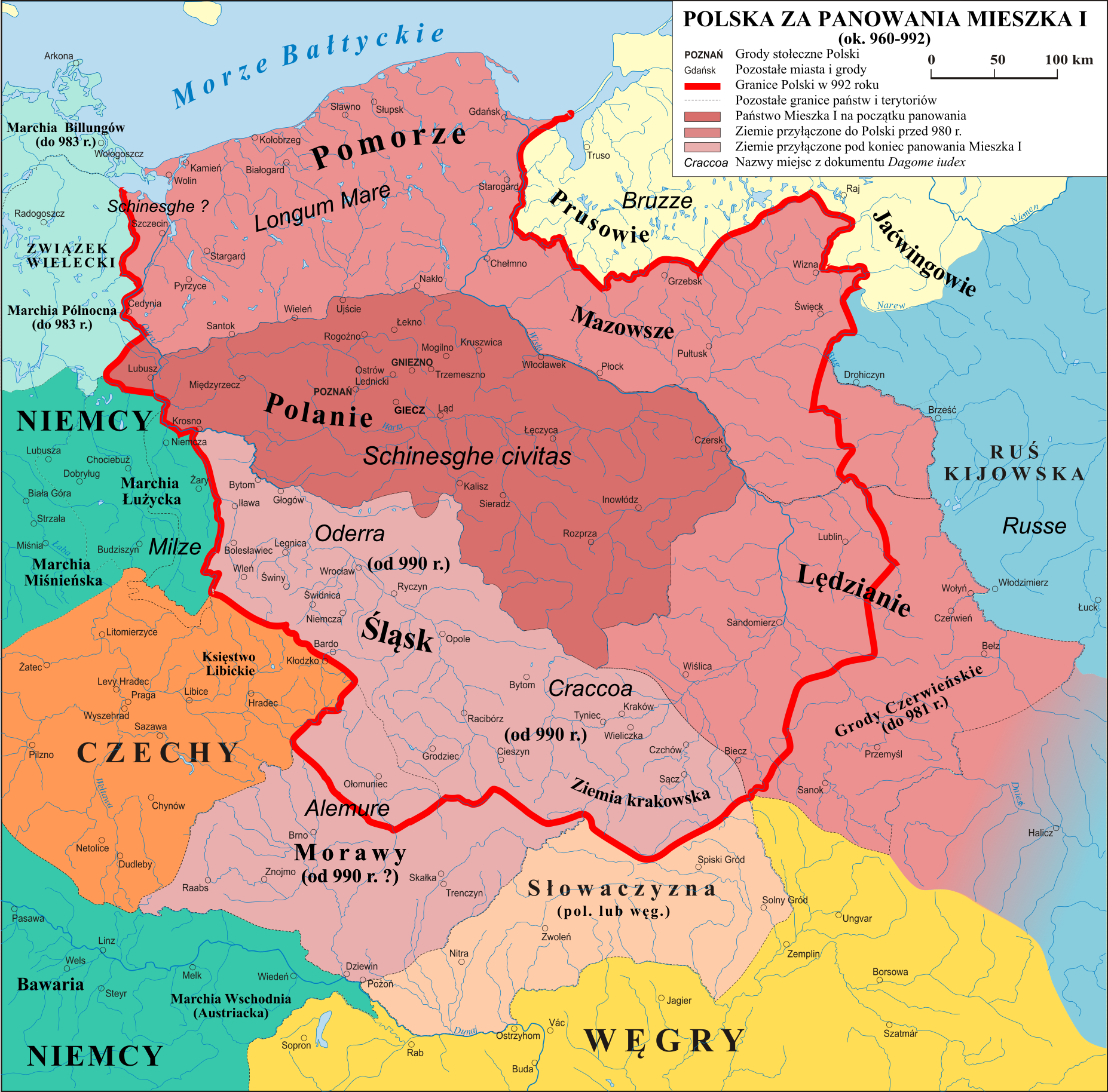

Poland under Mieszko's rule (ca. 960–992)
Mieszko I of Poland was the first historical ruler of Poland. He was responsible for the introduction and subsequent spread of Christianity in Poland.[20] During his long reign most of the territories inhabited by Polish tribes of West Slavs were united into a single Polish state. The last of his conquests were Silesia and Lesser Poland that were incorporated some time before 990.[21][22]
1025[]
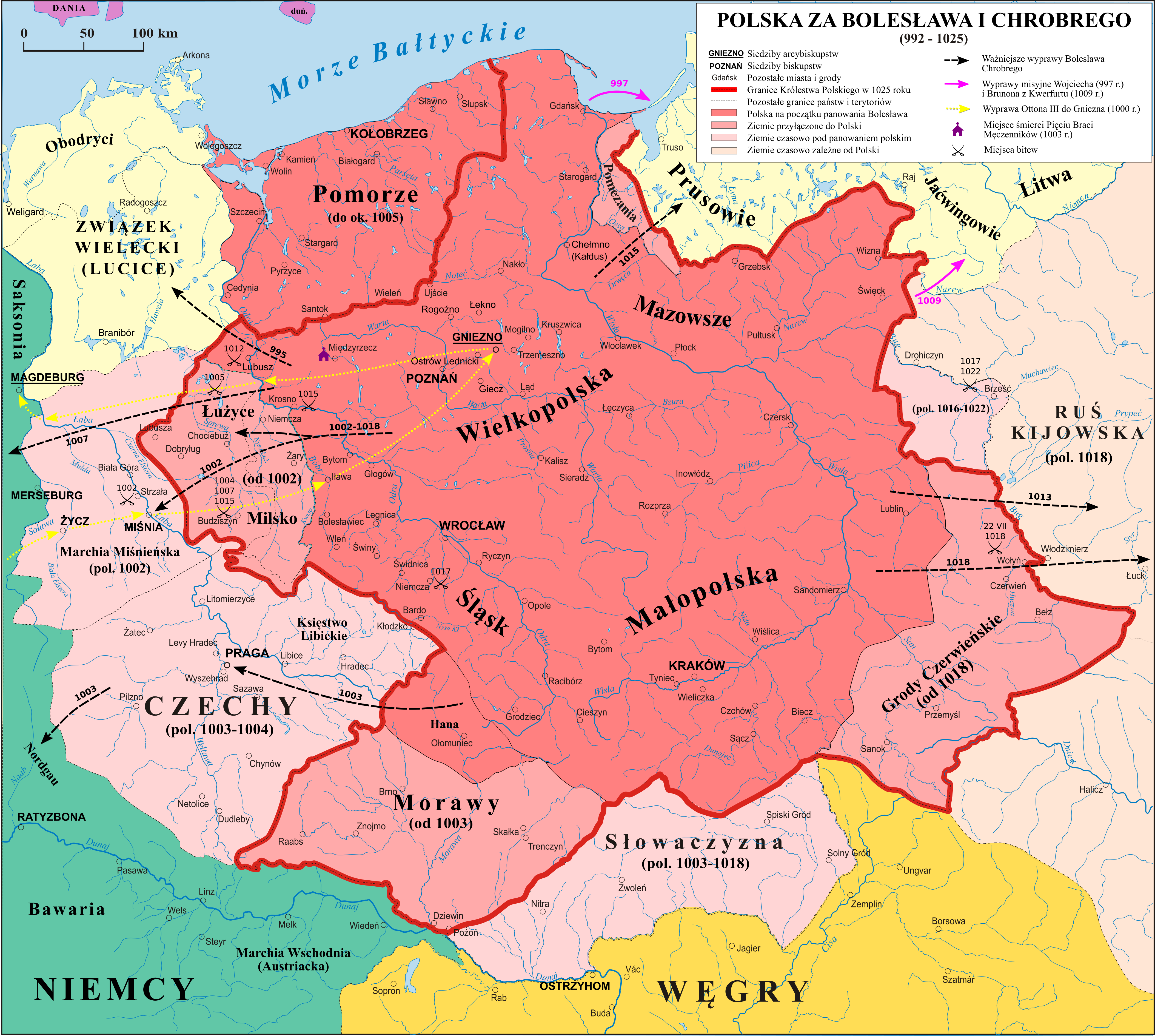

Poland during the reign of Bolesław the Brave
During the reign of Bolesław's the Brave, relations between Poland and the Holy Roman Empire deteriorated, resulting in a series of wars (1002–1005, 1007–1013, 1015–1018). From 1003–1004 Bolesław intervened militarily in Czech dynastic conflicts. After his forces were removed from Bohemia in 1018,[23] Bolesław retained Moravia.[24] In 1013 the marriage between Bolesław's son Mieszko and Richeza of Lotharingia, the niece of Emperor Otto III and future mother of Casimir I the Restorer, took place. The conflicts with Germany ended in 1018 with the Peace of Bautzen accord, on favorable terms for Bolesław. In the context of the 1018 Kiev expedition, Bolesław took over the western part of Red Ruthenia. In 1025, shortly before his death, Bolesław I the Brave finally succeeded in obtaining the papal permission to crown himself, and became the first king of Poland.[25][26]
1050[]


Poland during the rule of Casimir I of Poland
The first Piast monarchy collapsed after the death of Boleslaw's son - king Mieszko II in 1034. Deprived of a government, Poland was ravaged by an anti-feudal and pagan rebellion, and in 1039 by the forces of Bretislaus I of Bohemia. The country suffered territorial losses, and the functioning of the Gniezno archdiocese was disrupted.[27][28]
After returning from exile in 1039, Duke Casimir I (1016–1058), properly known as the Restorer have rebuilt the Polish monarchy and the country's territorial integrity through several military campaigns: in 1047, Masovia was taken back from Miecław, and in 1050 Silesia from the Czechs. Casimir was aided by the recent adversaries of Poland, the Holy Roman Empire and Kievan Rus', both of whom disliked the chaos in Poland. Casimir's son Bolesław II the Generous managed to restore most of the countries strength and influence and was able to crown himself king in 1076. In 1079 there was an anti-Bolesław conspiracy or conflict that involved the Bishop of Kraków. Bolesław had Bishop Stanislaus of Szczepanów executed; subsequently Bolesław was forced to abdicate the Polish throne because of the pressure from the Catholic Church and the pro-imperial faction of the nobility. The rule over Poland passed into the hands of his younger brother Władysław Herman.
1125[]

Poland during the rule of Bolesław III Wrymouth
After a power struggle, Bolesław III the Wry-mouthed (son of Władysław Herman, ruled 1102–1138) became the Duke of Poland by defeating his half-brother in 1106–1107. Bolesław's major achievement was the reconquest of all of Mieszko I's Pomerania, a task begun by his father and completed by Bolesław around 1123. Szczecin was subdued in a bloody takeover and Western Pomerania up to Rügen, except for the directly incorporated southern part, became Bolesław's fief,[29] to be ruled locally by Wartislaw I, the first duke of the Griffin dynasty.[30]
At this time, Christianization of the region was initiated in earnest, an effort crowned by the establishment of the Pomeranian Wolin Diocese after Bolesław's death in 1140.[30]
1145[]

Testament of Bolesław III Krzywousty:
The Testament of Bolesław III Krzywousty was a political act by the Piast duke Bolesław III Wrymouth of Poland,[31] in which he established rules for governance of the Polish kingdom by his four surviving sons after his death. By issuing it, Bolesław planned to guarantee that his heirs would not fight among themselves, and would preserve the unity of his lands under the House of Piast. However, he failed; soon after his death his sons fought each other, and Poland entered a period of fragmentation lasting about 200 years.[32]
1238[]


.JPG)
Monarchy of the Silesian Henries.
In the first half of the 13th century Silesian duke Henry I the Bearded, reunited much of the divided Kingdom of Poland (Regnum Poloniae). His expeditions led him as far north as the Duchy of Pomerania, where for a short time he held some of its southern areas.[33] He became the duke of Kraków (Polonia Minor) in 1232, which gave him the title of senior duke of Poland (see Testament of Bolesław III Krzywousty), and came into possession of most of Greater Poland in 1234. Henry failed in his attempt to achieve the Polish crown.[34] His activity in this field was continued by his son and successor Henry II the Pious, until his sudden death in 1241 (Battle of Legnica). His successors were not able to maintain their holdings outside of Silesia, which were lost to other Piast dukes. Polish historians refer to territories acquired by Silesian dukes in this period as Monarchia Henryków śląskich ("The monarchy of the Silesian Henries"). In those days Wrocław was the political center of the divided Kingdom of Poland.
1248[]
Few years after the death of Henry II the Pious his son - Bolesław II the Bald - sold the northwest part of his duchy - the Lubusz Land - to the to Magdeburg's Archbishop Wilbrand von Käfernburg and the Ascanian margraves of Brandenburg. This had far reaching negative consequences for the integrity of the western border, leading to an expansion of Brandenburg possessions into the east of Odra river. As a result a wide peace of Land was annexed from Poland and Pomerania that together with Lubusz Land formed the newly established Brandenburgian province of Neumark.[35]
1295[]

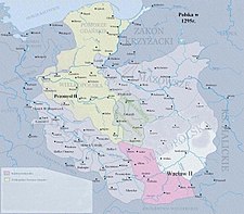
Poland in the times of Przemysł
In 1295, Przemysł II of Greater Poland became the first, since Bolesław II, Piast duke crowned as King of Poland, but he ruled over only a part of the territory of Poland (including from 1294 Gdańsk Pomerania) and was assassinated soon after his coronation.
1300[]


Poland in the times of Wenceslaus II:
A more extensive unification of Polish lands was accomplished by a foreign ruler, Wenceslaus II of Bohemia of the Přemyslid dynasty, who married Przemysł's daughter and became King of Poland in 1300. Václav's heavy-handed policies soon caused him to lose whatever support he had earlier in his reign; he died in 1305.[36]
1333-1370[]


Poland during the reign of Casimir the Great
After the death of Wenceslaus III of Bohemia - son of Wenceslaus II - in 1306, most of the Polish Lands came under the rule of duke Władysław I the Elbow-high. However at this points, various foreign states were staking their claims on some parts of Poland. Margraviate of Brandenburg invaded Pomerelia in 1308, leading Władysław I the Elbow-high to request assistance from the Teutonic Knights, who evicted the Brandenburgers but took the area for themselves, annexed and incorporated it into the Teutonic Order state in 1309 (Teutonic takeover of Danzig (Gdańsk) and Treaty of Soldin/Myślibórz). This event caused a long-lasting dispute between Poland and the Teutonic Order over the control of Gdańsk Pomerania. It resulted in a series of Polish–Teutonic Wars throughout 14th and 15th centuries.
During this time, all Silesian dukes accepted Władysław's claims for sovereignty over other Piasts. After acquiring papal consent for his coronation, all nine dukes of Silesia declared twice (in 1319 before and in 1320 after the coronation) that their realms lay inside the borders of the Polish Kingdom.[37] However, despite formal papal consent for the coronation, Wladyslaw's right to the crown was disputed by successors of Wenceslaus III (a king of both Bohemia and Poland) on the Bohemian throne. In 1327 John of Bohemia invaded. After the intervention of King Charles I of Hungary he left Polonia Minor, but on his way back he enforced his supremacy over the Upper Silesian Piasts.
In 1329 Władysław I the Elbow-high fought with the Teutonic Order. The Order was supported by John of Bohemia who dominated the dukes of Masovia and Lower Silesia.
In 1335 John of Bohemia renounced his claim in favour of Casimir the Great, who in return renounced his claims to the Silesia province.[38] This was formalized in the Treaty of Trentschin and Congress of Visegrád (1335), ratified in 1339[39] and later confirmed in the 1348 Treaty of Namslau.
King Casimir, being deprived of historically and ethnically Polish lands of Silesia and Pomerelia sought a compensation of this loses in the east. Through a series of military campaigns between 1340 and 1366 Casimir had annexed the Halych–Volodymyr area of Rus'. The city of Lwów quickly developed to become a main town of this new region.
Allied with Denmark and Western Pomerania, Casimir was able to impose some corrections on the western border as well. In 1365 Drezdenko and Santok became Poland's fiefs, while Wałcz district was in 1368 taken outright, severing the land connection between Brandenburg and the Teutonic state and connecting Poland with Farther Pomerania.[40]
1635[]


Blue and white stripes indicate Swedish control of Polish territory. Orange and white stripes represents the Duchy of Prussia
Sweden, weakened by involvement in the Thirty Years' War, agreed to sign the Armistice of Stuhmsdorf (also known as Treaty of Sztumska Wieś or Treaty of Stuhmsdorf) in 1635, favourable to the Polish-Lithuanian Commonwealth in terms of territorial concessions.[41]
1655[]


Blue represents the invasion by Sweden and Green the invasion by Russia
In the history of Poland and Lithuania, the Deluge refers to a series of wars in the mid-to-late 17th century that left the Polish-Lithuanian Commonwealth in ruins.[42]
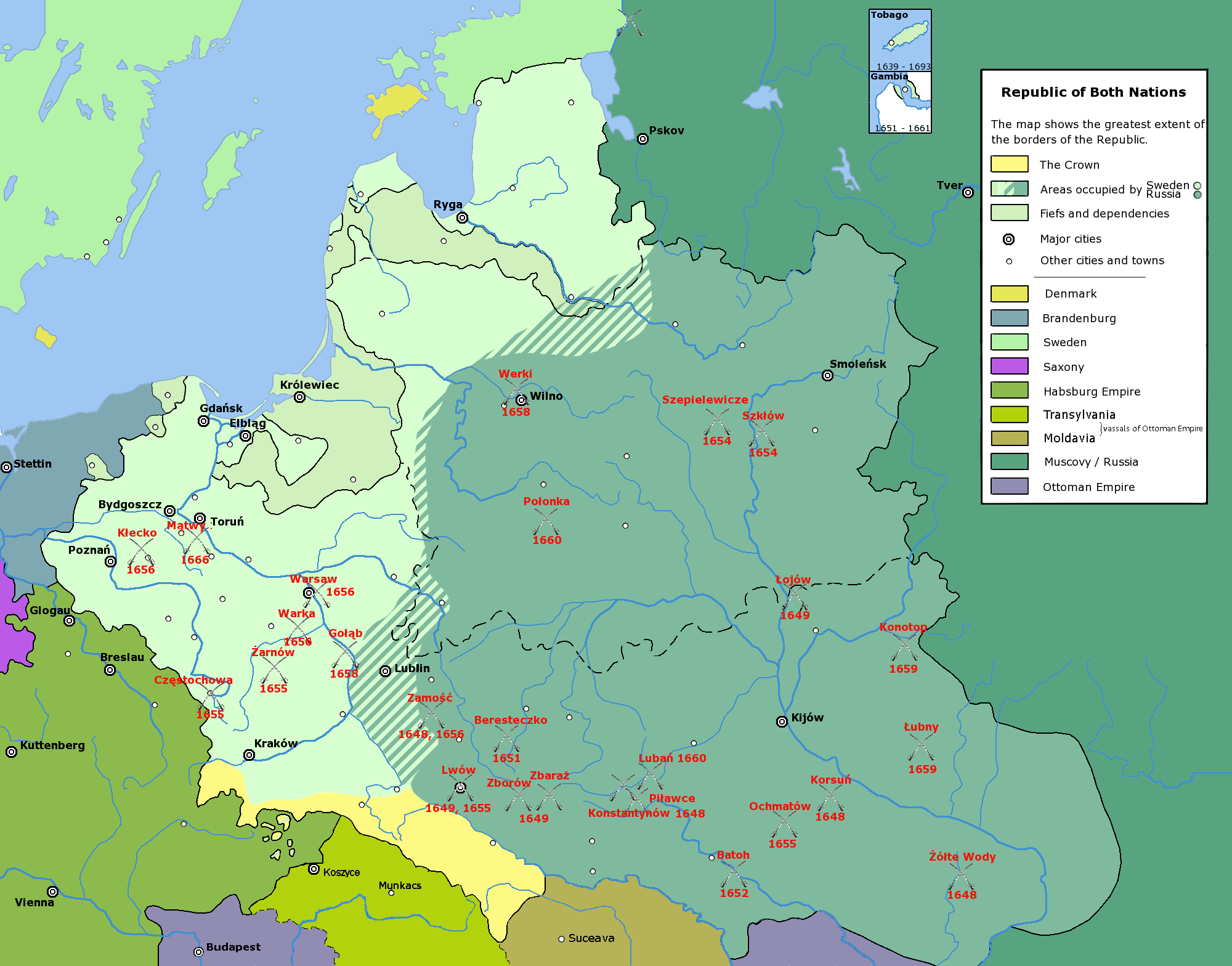

Foreign occupation of Poland during the Deluge
The Deluge refers to the Swedish invasion and occupation of the western half of Poland-Lithuania from 1655 to 1660 and the Khmelnytskyi Uprising in 1648, which led to Russia's invasion during the Russo-Polish War.[42]
1657[]


Blue and white stripes indicate Swedish control of Polish territory. Light green represents Russian occupation
The Treaty of Wehlau was a treaty signed on September 19, 1657, in the eastern Prussian town of Wehlau (Welawa, now Znamensk) between Poland and Brandenburg-Prussia during the Swedish Deluge. The treaty granted independence to Prussia in recognition of its help against the Swedish forces during the Deluge.[43]
1660[]
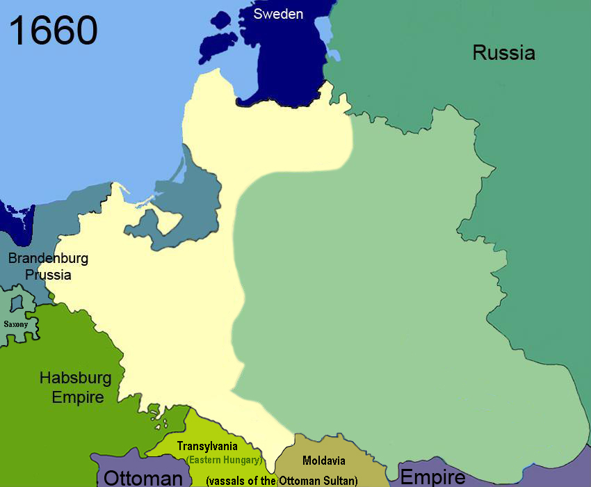

Light green represents Russian occupation
In the Treaty of Oliva, the Polish King, John II Casimir, renounced his claims to the Swedish crown, which his father Sigismund III Vasa had lost in 1599. Poland formally ceded Swedish Livonia and the city of Riga, which had been under de facto Swedish control since the 1620s.[44] The signing of the treaty ended Swedish involvement in the Deluge.


Map of Swedish Livonia
1667[]


The War for Ukraine ended with the Treaty of Andrusovo of January 13, 1667.[45] The peace settlement gave Moscow control over the so-called Left-bank Ukraine with the Polish Commonwealth retaining Right-bank Ukraine.[45] The signing of the Treaty ended Russian occupation of the Polish confederation and the Deluge war. Since the war started the population of the Polish-Lithuanian Commonwealth had been nearly halved by war and disease. War had destroyed the economic base of the cities and raised a religious fervour that ended Poland's policy of religious tolerance.[42]
1672[]


As a result of the Polish–Ottoman War the Polish commonwealth ceded Podolia in the 1672 Treaty of Buczacz.[46][47]


Region of Podolia
1686[]


The Eternal Peace Treaty of 1686 was a treaty between the Tsardom of Russia and the Polish-Lithuanian Commonwealth signed on May 6, 1686, in Moscow. It confirmed the earlier Truce of Andrusovo of 1667. The treaty secured Russia's possession of the Left-bank Ukraine, Zaporozh'ye, Seversk lands, the cities of Chernihiv, Starodub, and Smolensk and its outskirts, while Poland retained Right-bank Ukraine.[48]
1699[]


The Treaty of Karlowitz, or Treaty of Karlovci, was signed on January 26, 1699, in Sremski Karlovci, a town in modern-day Serbia. The Treaty of Karlowitz was signed following a two-month congress between the Ottoman Empire and the Holy League of 1684, a coalition of various European powers including the Habsburg Monarchy, the Polish-Lithuanian Commonwealth, the Republic of Venice, and the Russia of Peter I Alekseyevich.[49] The treaty concluded the Austro-Ottoman War of 1683–1697, in which the Ottoman side had finally been defeated at the Battle of Senta. The Ottomans ceded most of Hungary, Transylvania, and Slavonia to Austria while Podolia returned to Poland. Most of Dalmatia passed to Venice, along with the Morea (the Peloponnesus peninsula) and Crete.[48]
1772[]
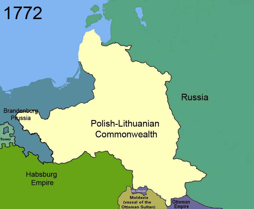

In February 1772, an agreement for the partition of the Polish-Lithuanian Commonwealth was signed in Vienna.[50] Early in August Russian, Prussian and Austrian troops simultaneously entered the Commonwealth and occupied the provinces agreed upon among themselves.
By the first partition in 1772, the Polish-Lithuanian Commonwealth lost about 211,000 square kilometres (81,000 sq mi) (30% of its territory, amounting at that time to about 733,000 square kilometres (283,000 sq mi)), with a population of over four to five million people (about a third of its population of 14 million before the partition).[51][52]
1793[]


By the 1790s the First Polish Republic had deteriorated into such a helpless condition that it was successfully forced into an unnatural and ultimately deadly alliance with its enemy, Prussia. The alliance was cemented with the Polish-Prussian Pact of 1790.[53] The conditions of the Pact were such that the succeeding and final two partitions of Poland were inevitable. The May Constitution of 1791 enfranchised the bourgeoisie, established the separation of the three branches of government, and eliminated the abuses of Repnin Sejm.
Those reforms prompted aggressive actions on the part of Poland's neighbours, wary of a potential renaissance of the Commonwealth. In the second partition, Russia and Prussia took so much territory that only one-third of the 1772 population remained in Poland.[54]
1795[]


Kosciuszko's ragtag insurgent armies, who fought to regain Polish territory, won some initial successes but they eventually fell before the superior forces of the Russian Empire.[55] The partitioning powers, seeing the increasing unrest in the remaining Commonwealth, decided to solve the problem by erasing any independent Polish state from the map. On 24 October 1795 their representatives signed a treaty dividing the remaining territories of the Commonwealth between their three countries.[56]
1807[]
Duchy of Warsaw[]


Napoleon's attempts to build and expand his empire kept Europe at war for almost a decade and brought him into conflict with the same European powers that had beleaguered Poland in the last decades of the previous century. An alliance of convenience was the result of this situation. Volunteer Polish legions attached themselves to Bonaparte's armies, hoping that in return the emperor would allow an independent Poland to reappear out of his conquests.[57]
The Duchy of Warsaw was a Polish state established by Napoleon in 1807 from the Polish lands ceded by the Kingdom of Prussia under the terms of the Treaties of Tilsit. The duchy was held in personal union by one of Napoleon's allies, King Frederick Augustus I of Saxony.[57]
Free City of Danzig (Napoleonic)[]
Prussia had acquired the City of Danzig in the course of the Second Partition of Poland in 1793. After the defeat of King Frederick William III of Prussia at the 1806 Battle of Jena-Auerstedt, according to the Franco-Prussian Treaty of Tilsit of 9 July 1807, the territory of the free state was carved out from lands that made up part of the West Prussia province.
1809[]


In 1809, a short war with Austria started. Although the Duchy of Warsaw won the Battle of Raszyn, Austrian troops entered Warsaw, but Duchy and French forces then outflanked their enemy and captured Kraków, Lwów and much of the areas annexed by Austria in the Partitions of Poland. After the Battle of Wagram, the ensuing Treaty of Schönbrunn allowed for a significant expansion of the Duchy's territory southwards with the regaining of once-Polish and Lithuanian lands.
1815[]
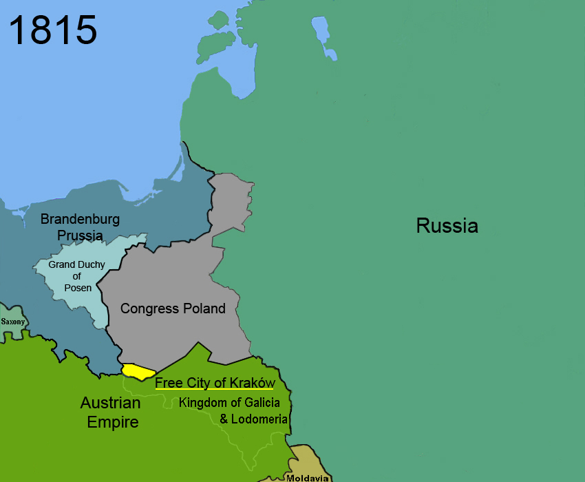
Following Napoleon's failed invasion of Russia, the duchy was occupied by Prussian and Russian troops until 1815, when it was formally partitioned between the two countries at the Congress of Vienna.[58]
Congress Poland[]
Congress Poland was created out of the Duchy of Warsaw at the Congress of Vienna in 1815, when European states reorganized Europe following the Napoleonic wars.[59]
Grand Duchy of Posen[]
The Grand Duchy of Posen was a region in the Kingdom of Prussia in the Polish lands commonly known as "Greater Poland" between the years 1815–1848. According to the Congress of Vienna it was to have autonomy. In practice it was subordinated to Prussia and the proclaimed rights for Poles were not respected. The name was unofficially used afterwards for denoting the territory, especially by Poles, and today is used by modern historians to describe different political entities until 1918. Its capital was Posen (Polish: Poznań).[59]
Free City of Kraków[]
The Free, Independent, and Strictly Neutral City of Kraków with its Territory, more commonly known as either the Free City of Kraków or Republic of Kraków, was a city-state created by the Congress of Vienna in 1815.[60]
1831[]


After the November Uprising, Congress Poland lost its status as a sovereign state in 1831 and the administrative division of Congress Poland was reorganized. Russia issued an "organic decree" preserving the rights of individuals in Congress Poland but abolished the Sejm. This meant Poland was subject to rule by Russian military decree.[61]
1846[]


In the aftermath of the unsuccessful Kraków Uprising, the Free City of Kraków was annexed by the Austrian Empire.[60]
1848[]

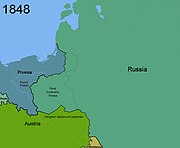
After the defeat of Congress Poland, many Prussian liberals sympathised with the demand for the restoration of the Polish state. In the spring of 1848 the new liberal Prussian government allowed some autonomy to the Grand Duchy of Posen in the hope of contributing to the cause of a new Polish homeland.[62] Due to a number of factors, including the outrage of the German-speaking minority in Posen, the Prussian government reversed course. By April 1848, the Prussian army had already suppressed the Polish militias and National Committees that emerged in March. By the end of the year the Duchy had lost the last vestiges of its formal autonomy, and was downgraded to a Province of the Prussian kingdom.[63]
1918[]


The red and green stripes represent the Treaty of Brest-Litovsk
The West Ukrainian People's Republic was proclaimed on November 1, 1918, with Lviv as its capital. The Republic claimed sovereignty over Eastern Galicia, including the Carpathians up to the city of Nowy Sącz in the west, as well as Volhynia, Carpathian Ruthenia and Bukovina. Although the majority of the population of the Western-Ukrainian People's Republic were Ukrainians, large parts of the claimed territory were considered Polish by the Poles. In Lviv the Ukrainian residents supported the proclamation, the city's significant Jewish minority accepted or remained neutral towards the Ukrainian proclamation, and the Polish majority was shocked to find themselves in a proclaimed Ukrainian state.[64]
1919[]
Creation of Poland[]


White and green stripes indicate the farthest the Russians were able to advance and the farthest the Poles were able to attack in Russia during the Polish-Soviet War. Blue and white stripes indicate fighting with the West Ukrainian People's Republic
In the aftermath of World War I the Polish people broke out in the Greater Poland Uprising on December 27, 1918, in Poznań after a patriotic speech by Ignacy Paderewski, a famous Polish pianist. The fighting continued until June 28, 1919, when the Treaty of Versailles was signed, which recreated the nation of Poland. From the defeated German Empire, Poland received the following:
- Most of the Prussian province of Posen was granted to Poland. This territory had already been taken over by local Polish insurgents during the Great Poland Uprising of 1918–1919.[65]
- 70% of West Prussia was given to Poland to provide free access to the sea, along with a 10% German minority, creating the Polish corridor.[7]
- The east part of Upper Silesia was awarded to Poland after a plebiscite. Sixty percent of residents voted for German citizenship, and 40 percent for Poland; as a result the area was divided.[7]
- To provide a Polish railway line connecting Gdańsk and Warsaw, the area of Działdowo (Soldau) in East Prussia was granted to the new Polish state.[66]
- From the eastern part of West Prussia and the southern part of East Prussia in the provinces of Warmia and Masuria, a small area was granted to Poland.[67]
Poland seizes West Ukrainian People's Republic[]


White and green stripes indicate the farthest the Russians were able to advance and the farthest the Poles were able to attack into Russia during the Polish-Soviet War
On July 17, 1919, a ceasefire was signed in the Polish–Ukrainian War with the West Ukrainian People's Republic (ZUNR). As part of the agreement Poland kept ZUNR territory. The West Ukrainian People's Republic then merged with the Ukrainian People's Republic (UNR).[68] On June 25, 1919, Supreme Allies Council transferred East Galicia (ZUNR territory) to Poland.[67]
Political regions of the former Russian Empire
Polish-Soviet War[]
White and green stripes indicate the farthest the Russians were able to advance and the farthest the Poles were able to attack into Russia during the Polish-Soviet War
The Polish–Soviet War (February 1919–March 1921) was an armed conflict between Soviet Russia and Soviet Ukraine on the one hand and the Second Polish Republic and the short-lived Ukrainian People's Republic on the other. The war was the result of conflicting expansionist ambitions. Poland, whose statehood had just been re-established by the Treaty of Versailles following the Partitions of Poland in the late 18th century, sought to secure territories it had lost at the time of the partitions. The aim of the Soviet states was to control those same territories, which the Russian Empire had gained in the partitions of Poland.[69]
")
")
")
")
")
1920[]
Free City of Danzig[]
The Free City of Danzig (Gdańsk) was created on 15 November 1920[70][71] in accordance with the terms of Article 100 (Section XI of Part III) of the 1919 Treaty of Versailles. As the Treaty stated, the region was to remain separated from Germany and from Poland, but it was not an independent state.[72] The Free City was under League of Nations protection and put into a binding customs union with Poland.
Poland was given full rights to develop and maintain transportation, communication, and port facilities in the city.[73] The Free City was created in order to give Poland access to a well-sized seaport.
Polish–Lithuanian War[]


Russian border shown though Treaty of Riga not signed
The Polish-Lithuanian War was an armed conflict between Lithuania and the Second Polish Republic, lasting from August 1920 to October 7, 1920, in the aftermath of World War I, not long after both countries had regained their independence. It was part of a wider conflict over disputed territorial control of the cities of Vilnius (Polish language: Wilno ), Suwałki and Augustów.

Lithuanian land claims
In the aftermath of the war the Republic of Central Lithuania was created in 1920 following the staged rebellion of soldiers of the 1st Lithuanian-Belarusian Infantry Division of the Polish Army, supported by the Polish air force, cavalry and artillery.[74] Centered on the historical capital of the Grand Duchy of Lithuania, Vilna (Lithuanian language: Vilnius , Polish language: Wilno ), for eighteen months the entity served as a buffer state between Poland, upon which it depended, and Lithuania, which claimed the area.[75]
Negotiations with Russia[]
Russian-Polish border agreed to on October 18, 1920
Soon after the Battle of Warsaw the Bolsheviks sued for peace. The Poles, exhausted, constantly pressured by the Western governments and the League of Nations, and with its army controlling the majority of the disputed territories, were willing to negotiate. The Soviets made two offers: one on September 21 and the other on September 28. The Polish delegation made a counteroffer on October 2. On the October 5, the Soviets offered amendments to the Polish offer, which Poland accepted. The armistice between Poland on the one side and Soviet Ukraine and Soviet Russia on the other was signed on October 12 and went into effect on October 18.[76] Long negotiations ensued, with the Treaty of Riga being signed in March 1921. The assessment of relative advantage is not universally agreed. Russian and Polish historians tend to assign victory to their respective countries. Outside assessments vary, mostly between calling the result a Polish victory and being inconclusive. However, in his secret report to the 9th Conference of the Bolshevik Party on 20 September 1920, Lenin called the outcome of the war "In a word, a gigantic, unheard-of defeat"[77]
Negotiations with Czechoslovakia[]


Territory adjustments between Czechoslovakia (green) and Poland (red).
During the closing years of World War I Polish and Czechoslovakian diplomats met to arrange a common border between the two new countries. By the time armistice was declared, most of the border was agreed except for three small politically sensitive areas with both Polish and Czechoslovak residents.
- The Duchy of Cieszyn
The Cieszyn Silesia or the Duchy of Cieszyn (German language: Teschen and Czech language: Tesin ) was a small area that the pre-World War I census showed was predominantly Polish in three districts (Teschen, Bielsko and Frysztat) and mainly Czech in the fourth district of Frydek. The economic importance of Cieszyn Silesia lay in the rich coal basin around Karvina and in the valuable Košice–Bohumín Railway, which linked Bohemia with Slovakia. In northern Cieszyn Silesia, the railroad junction of Bohumín (German language: Oderberg and Czech language: Bohumin ) served as a crossroads for international transport and communications.[78]
Claims over these regions turned violent in 1919 with a brief military conflict, the Seven-day war, between Polish and Czechoslovak units. The Allied governments pressed for a ceasefire and on 3 February 1919 a Polish-Czech border agreement was signed on the basis of the 5 November 1918 ethnic division agreement.[67] This was later changed at the Conference of Ambassadors in Spa, Belgium on 28 July 1920. Cieszyn (German language: Teschen) was divided along the Olza river between the two newly created states of Poland and Czechoslovakia. The smaller western suburbs of Cieszyn were joined to Czechoslovakia as the new town of Český Těšín along with the railroad and the Karvina coal basin.[79][78] Poland received the portion of Cieszyn east of the Olza river.[78] The Conference of Ambassadors divided the region just as the Red Army was nearing Warsaw. It was later learned that this award resulted from a secret deal between Edvard Beneš and French and British officials.[80]
- Orawa and Spisz
The county of Orawa (Slovak language: Orava) arose before the 15th century. The county's territory is situated along the Orava River between Zazriva and the Tatra Mountains. Spisz (Slovak language: Spiš) is situated between the High Tatras and the Dunajec River in the north, the springs of the Váh River in the west, the Slovak Ore Mountains and the Hnilec River in the south, and a line running from the town of Stara Ľubovňa, via the Branisko Mountains, to the town of Margecany in the east. While the Orawa and Spisz border was in arbitration, many groups fought to be a part of Poland, including a number of Polish authors. They began to write about an alleged three hundred thousand Poles living in the Orawa territory.[81]
The Conference of Ambassadors decided that Czechoslovakia would cede to Poland a number of villages from the Orawa and Spisz regions, including the municipalities of Oravy Srnie, Podvlk, Harkabúz, Nižná Zubrica, Vyšná Zubrica, Oravka, Bukovina-Podsklie, Pekelník, Jablonka, Chyžné, Hladovka, Suchá Hora, Vyšná Lipnica, a part of Nižné Lipnice and 4.2% of the rather Belá new communities, with Fridman (Falštin settlement), Krempach, Tribš, Durštín, Čierna Hora, Jurgov, Repiská, Vyšné lapse, Nižné lapse, Nedeca, Kacvín and Lapšanka.[82]
1921[]


Upper Silesian industrial district (red) to Poland after the Upper Silesia plebiscite in 1921
In late 1921 a border adjustment between the Weimar Republic and Poland took place as a result of the Silesian Uprisings. The uprising were a series of three armed rebellions that took place between 1919 and 1921 by the Polish people in the Upper Silesia region against the Weimar Republic. The Polish people of the region wanted to join the Second Polish Republic, which had been established following World War I. The 1919 Treaty of Versailles had called for a plebiscite in Upper Silesia in 1921 to determine whether the territory should be a part of Germany or Poland.[83]
The plebiscite took place on March 20, 1921, two days after the signing of the Treaty of Riga, which ended the Polish-Soviet war. In the plebiscite, 707,605 votes were cast for Germany, and 479,359 for Poland.[83] The Germans had a majority, by 228,246 votes. In late April 1921, rumours flew that Upper Silesia would stay in Germany. This led to the Third Polish Uprising in May–July 1921.[83] The question of the Upper Silesia problem was turned over to a council of the League of Nations. The commission, consisting of four representatives—one each from Belgium, Brazil, Spain, and China. The commission gathered its own data, interviewing Poles and Germans from the region. On the basis of the reports of this commission and those of its experts, on October 1921 the Council awarded the greater part of the Upper Silesian industrial district to Poland.[83]
1922[]


After a variety of delays, a disputed election to join Poland took place on January 8, 1922, and the Republic of Central Lithuania became part of Poland.[84]
1924[]

Lipnica Wielka (red) went to Poland and Suchá Hora and Hladovka (green) went to Czechoslovakia
The Polish government was not satisfied with the Czechoslovakia-Polish border decided from the Paris Peace Conference or from the Conference of Ambassadors. The conflict was only resolved by the Council of the League of Nations' Permanent Court of International Justice on March 12, 1924, which decided that Czechoslovakia should retain the territory of Javorzyna.[85] and which entailed (in June of the same year) an additional exchange of territories in Orava - the territory around Lipnica Wielka (Nižná Lipnica) went to Poland, the territory around Suchá Hora (Sucha Gora) and Hladovka (Glodowka) went to Czechoslovakia.[86]
1938[]


Territories in red seized by Poland
As Czechoslovakia was being absorbed into the German Reich, Zaolzie, the Czech half of Cieszyn, was annexed by Poland in 1938 following the Munich Agreement and the First Vienna Award. At noon on September 30, Poland gave an ultimatum to the Czechoslovak government. It demanded the immediate evacuation of Czech troops and police from Zaolzie and gave Prague until noon the following day. At 11:45 a.m. on October 1 the Czech foreign ministry called the Polish ambassador in Prague and told him that Poland could have what it wanted. Poland was accused of being an accomplice of Nazi Germany – a charge that Warsaw was hard put to deny.[87]


The dismemberment of Czechoslovakia
Poland seized land from northern Spisz and northern Orawa, including territories around Suchá Hora and Hladovka, around Javorina, around Leśnica in the Pieniny Mountains, a small territory around Skalité, and some other very small border regions. They officially received the territories on 1 November 1938. Polish military groups began to carry out assimilation of the population. Polish was introduced as the only official language and the Slovak Intelligence were displaced from the territories.[88]
1939[]


World War II[]
In 1939, Germany and the Soviet Union invaded Poland and partitioned it pursuant to the Molotov-Ribbentrop Pact.[89]
After the invasion, Germany annexed the lands it lost to reformed Poland in 1919–1922 by the Treaty of Versailles: the Polish Corridor, West Prussia, the Province of Posen, and parts of eastern Upper Silesia. The council of the Free City of Danzig voted to become a part of Germany again, although Poles and Jews were deprived of their voting rights and all non-Nazi political parties were banned. Parts of Poland that had not been part of Wilhelmine Germany were also incorporated into the Reich.
Two decrees by Adolf Hitler (October 8 and October 12, 1939) provided for the division of the annexed areas of Poland into the following administrative units:
- Reichsgau Wartheland (initially Reichsgau Posen), which included the entire Poznań Voivodeship, most of the Łódź Voivodeship, five counties of the Pomeranian Voivodeship, and one county of the Warszawa Voivodeship;
- Reichsgau Danzig-West Prussia (initially Reichsgau West Prussia), which consisted of the remaining area of the Pomeranian Voivodeship and the Free City of Danzig;
- Ciechanów District (Regierungsbezirk Zichenau), consisting of the five northern counties of Warszawa Voivodeship (Płock, Płońsk, Sierpc, Ciechanów, and Mława), which became a part of East Prussia;
- Katowice District (Regierungsbezirk Kattowitz), or unofficially East Upper Silesia (Ost-Oberschlesien), which included Sosnowiec, Będzin, Chrzanów, and Zawiercie Counties, and parts of Olkusz and Żywiec Counties.

USSR and Nazi Germany carve up Poland
These territories had an area of 94,000 square kilometres (36,000 sq mi) and a population of 10,000,000 people. The remaining Polish territory was annexed by the Soviet Union or made into the German-controlled General Government occupation zone. Eastern areas of Poland became part of either Soviet Belarus (including Białystok, Łomża, Baranowicze and Brest) or Soviet Ukraine (including Lwów, Tarnopol, Lutsk, Rowne and Stanisławów). The city of Vilnius (Polish: Wilno) with its adjacent area was annexed and returned to Lithuania.
After the German attack on the Soviet Union in June 1941, the district of Białystok, which included the Białystok, Bielsk Podlaski, Grajewo, Łomża, Sokółka, Volkovysk, and Grodno Counties, was "attached to" (not incorporated into) East Prussia. The former Lwow, Stanislawow and Tarnopol Voivoideships were annexed to the General Government, forming its fifth district, Distrikt Galizien.
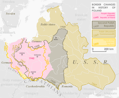
1945[]

On Victory in Europe Day (V-E Day: May 8, 1945) World War II Allies formally accepted the unconditional surrender of Nazi Germany.
After World War II, there were extensive changes to the territorial extent of Poland, following the decision taken at the Teheran Conference of 1943 at the insistence of the Soviet Union. The Polish territories east of the Curzon Line, which the Soviet Union had occupied in 1939 along with the Bialystok region, were permanently annexed.[90] While a large portion of this area was predominately populated by Ukrainians and Belarussians, most of their Polish inhabitants were expelled.[91] Today these territories are part of Belarus, Ukraine and Lithuania.
Poland received former German territory east of the Oder-Neisse line, consisting of the southern two thirds of East Prussia and most of Pomerania, Neumark (East Brandenburg), and Silesia. The German population was expelled before these formerly occupied territories were repopulated mainly with Poles from central Poland and those expelled from the eastern regions.[92] Early expulsions in Poland were undertaken by the occupying Soviet and Polish Communist military authorities[92] even before the Potsdam Conference ("wild expulsions").
")
")
")
")
Poland USSR[]


Border adjustment between Poland and the USSR on 16 August 1945
On August 16, 1945, a border agreement between Poland and the USSR was signed. The western portion of the Byelorussian SSR was granted to Poland. The Belastok Voblast was divided into Soviet Brest Voblast, Hrodna Voblast and Polish Białystok Voivodeship.[93]
As a result, Poland lost about 178,000 sq km of its pre-war territory in the east, but gained some 101,000 sq km in the west and north.[94]
")
")
Czechoslovakia[]
After World War II the Czechoslovakian government wanted to return to the 1920 border between the two nations, while Polish inhabitants of Zaolzie were in favour of the boundary of August 31, 1939. On May 20, 1945, in Trstena an agreement for a return to the 1938 borders of Poland was signed and the following day the Czechoslovak border guards moved to the old Czechoslovakian border. At several places there were fights between Polish and Czechoslovakian militias, but the situation calmed with the arrival of Polish troops on July 17, 1945.[95] The Polish government still did not want to give up Zaolzie, and on June 16, 1945, Marshall Michał Rola-Żymierski issued directive number 00336, which ordered the 1st Armoured Corps of the Polish Army to concentrate in the area of Rybnik, and to seize Zaolzie.[96] However, the Soviets decided to hand the region to Czechoslovakia, and the Poles followed the Moscow directive. The Czechs demanded former German areas of Klodzko, Glubczyce, and Racibórz, but after Soviet mediation, all sides signed a treaty on September 21, 1945, which accepted the December 31, 1937, Polish - Czechoslovak and Czechoslovak - German borderline as the boundary between the two countries.[97]
1948[]


Village of Medyka near Przemyśl was transferred to Poland
The Polish border underwent a minor correction in 1948, when the village of Medyka near Przemyśl was transferred to Poland.[98]
1951[]


On February 15, 1951 Aleksander Zawadzki, the president of the Polish Republic, and Andrey Vyshinsky, the Presidium of the Supreme Soviet of the Union of Soviet Socialist Republics, signed Treaty No. 6222. Agreement between the Polish republic and the Union of Soviet Socialist Republics concerning the exchange of sectors of their state territories. The treaty was a border adjustment, with Poland and the Soviet Union exchanging 480 square kilometres (190 sq mi). [99]
1955[]
In 1955 a small area of land on Usedom Island (Polish: Uznam) was ceded from the GDR (Eastern Germany) to Poland. The water pump station of Swinemünde lies on that land and was therefore handed over to Poland.
1958[]
On June 13, 1958, the Agreement concerning the final demarcation of the state frontier between Czechoslovakia and Poland was signed in Warsaw. Adam Rapacki signed for Poland and Václav David signed for Czechoslovakia. The treaty confirmed the border at the line of January 1, 1938, the situation before the Nazi-imposed Munich Agreement transferred territory from Czechoslovakia to Poland.[100]
1975[]


Territorial changes along the Dunajec river 1975
In March 1975 Czechoslovakia and Poland modified their border along the Dunajec to permit Poland to construct a dam in the Czorsztyn region, southeast of Kraków.[101]
2002[]


Territorial changes between Poland and Slovakia in 2002
In 2002, Poland and Slovakia made some further minor border adjustments:
Territory of the Republic of Poland with a total area of 2,969 m2 (31,958.05 sq ft), including:
a) in the area of a viewing tower on the surface of the saddle Dukielskie about 376 m², according to documents limit referred to in Article 1, paragraph 2
b) on the nameless island with an area of 2,289m², according to documents limit referred to in Article 1, paragraph 3
c) in the Polish village Jaworzynka region with an area of 304 m², according to documents limit referred to in Article 1, paragraph 4, including real estate, equipment and plants are transferred to the ownership of the Slovak Republic.
Territory of the Slovak Republic with an area of 2,969 m², including:a) in the area of a viewing tower on Dukielskie enters an area of 376 m², according to documents limit referred to in Article 1, paragraph 2
b) Nokiel on the island with an area of 2,289 m², according to documents limit referred to in Article 1, paragraph 3
c) in the Slovak village Skalité region with an area of 304 m², according to documents limit referred to in Article 1, paragraph 4, including real estate, equipment and plants are transferred to the ownership of the Republic of Poland.
— Dziennik Ustaw z 2005 r. Nr 203 poz. 1686, .[102]
See also[]
- Polish–Czechoslovak border conflicts
- Borders of Poland
- Geography of Poland
- Treaty of Warsaw (1970)
References[]
Bibliography[]
- de Zayas, Alfred M.: Nemesis at Potsdam. London, 1977. ISBN 0-8032-4910-1.
- de Zayas, Alfred M.: A terrible Revenge. Palgrave/Macmillan, New York, 1994. ISBN 1-4039-7308.3.
- Douglas, R.M.: Orderly and Humane. The Expulsion of the Germans after the Second World War. Yale University Press, 2012. ISBN 978-0-30016-660-6.
- Kleineberg, A.; Marx, Ch.; Knobloch, E.; Lelgemann, D.: Germania und die Insel Thule. Die Entschlüsselung voon Ptolemaios`"Atlas der Oikumene". WBG, 2010. ISBN 978-3-534-23757-9.
- Naimark, Norman: Fires of Hatred. Ethnic Cleansing in Twentieth-Century Europe. Cambridge, Harvard University Press, 2001.
- Prauser, Steffen and Rees, Arfon: The Expulsion of the "German" Communities from Eastern Europe at the End of the 2nd World War. Florence, Italy, European University Institute, 2004.
- Arthur Bliss Lane. I saw Poland betrayed: An American Ambassador Reports to the American People (1965 ed.). Western Islands; 1stED, 1stPrinting. edition. p. 276. ISBN 82-488-7370-6.
- Davies, Norman (2005). God's Playground. A History of Poland. Volume I: The Origins to 1795.. Oxford: Oxford University Press. p. 23.
- Grzegorz Rąkowski (in Polish). Ziemia lwowska (2007 ed.). Opublikowana przez Oficyna Wydawnicza "Rewasz". p. 577. ISBN 83-89188-66-X.
- Spielvogel, Jackson J. (14 January 2008). Western Civilization: Alternate Volume: Since 1300. Cengage Learning. ISBN 978-0-495-55528-5. http://books.google.com/books?id=aAgi_5xIVBMC. Retrieved 22 April 2010.
Footnotes[]
- ↑ UN Statistics
- ↑ CIA Factbook
- ↑ 3.0 3.1 "Concise Statistical Yearbook of Poland, 2008" (PDF). Central Statistical Office (Poland). 28 July 2008. Archived from the original on 2011-07-14. http://web.archive.org/web/20110714055236/http://www.stat.gov.pl/cps/rde/xbcr/gus/PUBL_maly_rocznik_statystyczny_2008.pdf. Retrieved 2008-08-12.
- ↑ 4.0 4.1 Davies, Norman (2005). God's Playground. A History of Poland. Volume I: The Origins to 1795.. Oxford: Oxford University Press. p. 23.
- ↑ Davies, Norman (2005). God's Playground. A History of Poland. Volume I: The Origins to 1795.. Oxford: Oxford University Press. p. 24.
- ↑ Felipe Fernandez-Armesto, ed (1994). The Times Guide to the Peoples of Europe. London: Times Books. pp. 275–6. ISBN 0-7230-0624-5.
- ↑ 7.0 7.1 7.2 pg 44 - Von Lewis Bernstein Namier. In the margin of history (June 1939 ed.). Ayer Co Pub. p. 303. ISBN 0-8369-0050-2.
- ↑ "Poland". Encyclopædia Britannica. 2009. http://www.britannica.com/EBchecked/topic/466681/Poland. Retrieved May 23, 2009. "Established as a kingdom in 922 under Mieszko I, Poland was united with Lithuania in 1386 under the Jagiellon dynasty (1386–1572) to become the dominant power in east-central Europe, enjoying a prosperous golden age."
- ↑ "Heritage: Interactive Atlas: Polish-Lithuanian Commonwealth". Public Broadcasting Service. 2009. http://www.pbs.org/wnet/heritage/episode5/atlas/map3.html#. Retrieved May 23, 2009. "At its apogee, the Polish-Lithuanian Commonwealth comprised some 400,000 square miles (1,000,000 km2) and a multi-ethnic population of 11 million."
- ↑ pg 554 - Norman Davies. Europe: A History (January 20, 1998 ed.). Harper Perennial. p. 1392. ISBN 0-06-097468-0.
Poland-Lithuania was another country that experienced its 'Golden Age' during the sixteenth and early seventeenth centuries. The realm of the last Jagiellons was absolutely the largest state in Europe. - ↑ pg 51 - Yale Richmond. From Da to Yes: Understanding the East Europeans (April 1995 ed.). Intercultural Press. p. 364. ISBN 1-877864-30-7.
"the deluge," denoting the downfall of Poland, at that time the largest state in Europe, stretching from the Baltic to the Black Sea and from the Oder to the Dnieper River. - ↑ pg 3 - Maciej Janowski. Polish liberal thought before 1918 (2004 ed.). Central European University Press. p. 282. ISBN 963-9241-18-0.
- ↑ pg 84 - Paul W. Schroeder. The Transformation of European Politics 1763–1848 (1996 ed.). Oxford University Press; Edition: illustrated. p. 920. ISBN 0-19-820654-2.
enabled them to push a new constitution through the Diet, transforming Poland from an anarchic republic ... into a reasonably modern constitutional monarchy - ↑ pg 34 - Rett R. Ludwikowski. Constitution-making in the Region of Former Soviet Dominance: With Full Texts of All New Constitutions Ratified Through July 1995 (1996 ed.). Duke University Press; Edition: illustrated. p. 641. ISBN 0-8223-1802-4.It was Poland more than any other Western European country that became the early symbol of a liberal and constitutional monarchy.
- ↑ "Lublin, Union of". Encyclopædia Britannica. 2009. http://www.britannica.com/EBchecked/topic/350412/Union-of-Lublin. Retrieved May 23, 2009. "Formally, Poland and Lithuania were to be distinct, equal components of the federation… But Poland, which retained possession of the Lithuanian lands it had seized, had greater representation in the Diet and became the dominant partner."
- ↑ pg 373 - Halina Stephan. Living in translation: Polish writers in America (2003 ed.). Rodopi. p. 382. ISBN 90-420-1016-9.Quoting from Sarmatian Review academic journal mission statement: Polish-Lithuanian Commonwealth was […] characterized by religious tolerance unusual in pre-modern Europe
- ↑ pg 122 - Feliks Gross. Citizenship and ethnicity: the growth and development of a democratic multi-ethnic institution (1999 ed.). Greenwood Publishing Group; Edition: illustrated. p. 144. ISBN 0-313-30932-9.[Poland] secured for a time a rule of religious tolerance, particularly in the sixteenth and seventeenth centuries ... The situation changed, however, toward the end of the seventeenth and eighteenth centuries.
- ↑ NationMaster.com 2003–2007, Poland, Facts and figures
- ↑ "Past and Present Regions of Poland". University at Buffalo, The State University of New York. 2009. http://info-poland.buffalo.edu/classroom/regions.html. Retrieved May 23, 2009.
- ↑ Jerzy Lukowski; W. H. Zawadzki (6 July 2006). A Concise History of Poland. Cambridge University Press. pp. 9–10. ISBN 978-0-521-85332-3. http://books.google.com/books?id=HMylRh-wHWEC&pg=PA9. Retrieved 5 April 2012.
- ↑ Andrzej Buko, "Archeologia Polski wczesnośredniowiecznej", 2007, Ed. Trio.
- ↑ Thietmari chronicon, vol. I p. 33; argument presented by G. Labuda, Mieszko I, p. 171.
- ↑ Makk, Ferenc (1993). Magyar külpolitika (896-1196) ("The Hungarian External Politics (896-1196)"). Szeged: Szegedi Középkorász Műhely. pp. 48–49. ISBN 963-04-2913-6.
- ↑ Ed. Andrzej Chwalba, Kalendarium dziejów Polski (Chronology of Polish History), p. 33, Krzysztof Stopka. Copyright 1999 Wydawnictwo Literackie Kraków, ISBN 83-08-02855-1.
- ↑ Jerzy Wyrozumski, Historia Polski do roku 1505 (History of Poland until 1505), Państwowe Wydawnictwo Naukowe (Polish Scientific Publishers PWN), Warszawa 1986, ISBN 83-01-03732-6, pp. 88–93
- ↑ Various authors, ed. Marek Derwich and Adam Żurek, U źródeł Polski (do roku 1038) (Foundations of Poland (until year 1038)), p. 168–183, Andrzej Pleszczyński
- ↑ Jerzy Wyrozumski, Historia Polski do roku 1505 (History of Poland until 1505), Państwowe Wydawnictwo Naukowe (Polish Scientific Publishers PWN), Warszawa 1986, ISBN 83-01-03732-6, pp. 93–96
- ↑ Various authors, ed. Marek Derwich and Adam Żurek, U źródeł Polski (do roku 1038) (Foundations of Poland (until year 1038)), pp. 182–187, Andrzej Pleszczyński
- ↑ Atlas historyczny Polski (Atlas of Polish History), 14th edition, ISBN 83-7000-016-9, PPWK Warszawa–Wrocław 1998, p. 5
- ↑ 30.0 30.1 Jerzy Wyrozumski, Historia Polski do roku 1505 (History of Poland until 1505), Państwowe Wydawnictwo Naukowe (Polish Scientific Publishers PWN), Warszawa 1986, ISBN 83-01-03732-6, pp. 101–104
- ↑ Norman Davies, God's Playground, pages: xxvii
- ↑ Norman Davies, God's Playground, page: 60
- ↑ Benedykt Zientara, Stanisław Smolka, Peter Oliver Loew, Heinrich der bärtige und seine Zeit: Politik und Gesellschaft im mittelalterlichen Schlesien, Oldenbourg Wissenschaftsverlag, 2002, p. 338, ISBN 3-486-56615-6
- ↑ Zientara 1997, pp. 317-320.
- ↑ Wiktor Fenrych, Nowa Marchia w dziejach politycznych Polski w XIII i w XIV wiekuPoznań 1959, p. 5
- ↑ Jerzy Wyrozumski, Historia Polski do roku 1505 (History of Poland until 1505), Państwowe Wydawnictwo Naukowe (Polish Scientific Publishers PWN), Warszawa 1986, ISBN 83-01-03732-6, pp. 129–141, 154–155
- ↑ Rudolf Žáček [in:] J. Bahlacke, D. Gawrecki, R. Kaczmarek (red.) Historia Górnego Śląska, Gliwice 2011, p. 114-115, ISBN 978-83-60470-41-1, ISBN 978-83-60353-99-8, ISBN 978-83-932012-1-1
- ↑ Encyclopædia Britannica: Silesia
- ↑ (Polish) Norman Davies, Roger Moorhouse (2002). Znak. ed. Mikrokosmos. Kraków. p. :127. ISBN 83-240-0172-7.
- ↑ Jerzy Wyrozumski, Historia Polski do roku 1505 (History of Poland until 1505), Państwowe Wydawnictwo Naukowe (Polish Scientific Publishers PWN), Warszawa 1986, ISBN 83-01-03732-6, pp. 160–171
- ↑ Władysław Czapliński. Władysław IV i jego czasy (2008 ed.). Universitas. p. 403. ISBN 83-242-0873-9. 9788324208739.
- ↑ 42.0 42.1 42.2 "The Deluge, 1648-67". USA.gov. 2009. http://countrystudies.us/poland/9.htm. Retrieved May 22, 2009.
- ↑ "Treaty of Wehlau". Encyclopædia Britannica, Inc.. 2009. http://www.britannica.com/EBchecked/topic/638853/Treaty-of-Wehlau#ref=ref248333. Retrieved May 23, 2009. "(Sept. 19, 1657), agreement in which John Casimir, king of Poland from 1648 to 1668, renounced the suzerainty of the Polish crown over ducal Prussia and made Frederick William, who was the duke of Prussia as well as the elector of Brandenburg (1640–88), the duchy’s sovereign ruler."
- ↑ "Peace of Oliva". Peace of Oliva. Microsoft Encarta Online Encyclopedia. 2009. http://encarta.msn.com/encyclopedia_762509459/peace_of_oliva.html. Retrieved May 23, 2009.
- ↑ 45.0 45.1 Rickard, J (July 26, 2007). "Truce of Andrusovo". historyofwar.org. http://www.historyofwar.org/articles/truce_andrusovo.html. Retrieved May 23, 2009.
- ↑ Dariusz Kolodziejczyk (2009). "The Ottoman Survey Register of Podolia (ca. 1681)". Harvard. http://www.hup.harvard.edu/catalog/KOLOTT.html. Retrieved May 23, 2009.
- ↑ "Polish-Ottoman War, 1672–1676". zum.de. November 19, 2004. http://www.zum.de/whkmla/military/17cen/polott16721676.html. Retrieved May 23, 2009.
- ↑ 48.0 48.1 "Eternal Peace of 1686". Encyclopedia of Ukraine. 2009. http://www.encyclopediaofukraine.com/pages/E/T/EternalPeaceof1686.htm. Retrieved May 23, 2009.
- ↑ pg 86 - Robert Bideleux, Ian Jeffries. A History of Eastern Europe: Crisis and Change (New York, 1998 ed.). Routledge. ISBN 0-415-16111-8.
- ↑ "Catherine the Great (1729–1796)". BBC News. 2009. http://www.bbc.co.uk/history/historic_figures/catherine_the_great.shtml. Retrieved May 23, 2009.
- ↑ Poland, Partitions of. (2008). Encyclopædia Britannica. Retrieved April 28, 2008, from Encyclopædia Britannica Online: http://www.britannica.com/eb/article-9060581
- ↑ pg 97 - Jerzy Lukowski, Hubert Zawadzki. A concise history of Poland (2001 ed.). Cambridge University Press; Edition: 5. p. 317. ISBN 0-521-55917-0.
- ↑ pg 128 - Piotr Stefan Wandycz. The Price of Freedom: A History of East Central Europe from the Middle Ages to the Present (May 29, 2001 ed.). Routledge; 2 edition. p. 360. ISBN 0-415-25490-6.pg 128 - The result was the March 1790 Polish-Prussian alliance ... Warsaw's viewpoint the alliance made sense, but the sejm's refusal to pay Prussia's price for it ... made it of problematic value.
- ↑ pg 101-103 - Jerzy Lukowski, Hubert Zawadzki. A Concise History of Poland (October 1, 2001 ed.). Cambridge University Press; illustrated edition. p. 335. ISBN 0-521-55917-0.pg 101-103 - the Prussians and the Russians signed a second treaty of Partition in St Petersburg on 23 January 1793. Catherine would take a slab of land ... William would acquire a triangle of territory between Silesia and East Prussia.
- ↑ Bartłomiej Szyndler (in Polish). Powstanie kościuszkowskie (1994 ed.). Wydawn. Ancher. p. 455. ISBN 83-85576-10-X.
- ↑ "The Three Partitions, 1764-95". USA.gov. 2009. http://countrystudies.us/poland/11.htm. Retrieved May 23, 2009.
- ↑ 57.0 57.1 "Constitution of the Duchy of Warsaw". poland.pl. 2009. http://www.poland.pl/archives/postpartionera/article,,id,11572.htm. Retrieved May 23, 2009.
- ↑ Marjie Bloy, Ph.D., Senior Research Fellow, National University of Singapore (April 30, 2002). "The Congress of Vienna, 1 November 1814 — 8 June 1815". victorianweb.org. http://www.victorianweb.org/history/forpol/vienna.html. Retrieved May 23, 2009.
- ↑ 59.0 59.1 Agnieszka B. Nance. Literary and Cultural Images of a Nation without a State: The Case of Nineteenth-Century Poland (August 1, 2008 ed.). Peter Lang Publishing. p. 182. ISBN 0-8204-7866-0.
- ↑ 60.0 60.1 pg 55 - Rosemary A. Chorzempa. Polish Roots (January 2000 ed.). Genealogical Publishing Company. p. 240. ISBN 0-8063-1378-1.
- ↑ pg 65 - Tim Chapman. Imperial Russia, 1801–1905 (July 3, 2001 ed.). Routledge; 1 edition. p. 160. ISBN 0-415-23110-8.
- ↑ pg 107 - John Breuilly. Nationalism and the State (September 1995 ed.). Manchester University Press; 2 edition. p. 492. ISBN 0-7190-3800-6.
Many Prussian liberals sympathised with the demand for the restoration of the Polish state. Since the defeat of the uprising of the 1830-31 in Congress Poland ... In the spring of 1848 the new liberal Prussian government allowed some autonomy to Posen in the hope of contributing to the cause of restoration. - ↑ pg 178 -Robert Bideleux. A History of Eastern Europe: Crisis and Change (January 28, 1998 ed.). Routledge; 1 edition. p. 704. ISBN 0-415-16111-8.
April 1848 ... the Prussian army had already suppressed the [Grand Duchy of Posen] Polish militias and National Committee which had emerged in March. After 1848 [Grand Duchy of Posen] lost the last vestiges of its formal autonomy, and was downgraded to a mere Provinz of the Prussian kingdom... - ↑ pg 367-368 - Orest Subtelny. Ukraine: a history (December 20, 2000 ed.). University of Toronto Press; 3rd edition. p. 800. ISBN 0-8020-8390-0.
- ↑ pg 178 - George J. Lerski. Historical Dictionary of Poland, 966-1945 (January 30, 1996 ed.). Greenwood Press. p. 784. ISBN 0-313-26007-9.
- ↑ "Działdowo Years 1871–1920". The City Działdowo. 2006. http://www.dzialdowo.pl/?miasto.historia.1871_1920. Retrieved May 23, 2009. "Zasadniczym i podstawowym powodem powyższej decyzji zapisanej w artykule 28 traktatu była konieczność włączenia do Polski obszaru linii kolejowej łączącej Gdańsk z Warszawą. - Translation - The primary and fundamental reason for this decision, enshrined in article 28 of the Treaty, was the need to integrate the Polish area of the railway line connecting Gdańsk and Warsaw."
- ↑ 67.0 67.1 67.2 Iwo Cyprian Pogonowski. Poland: A Historical Atlas (March 1989 ed.). Hippocrene Books; Revised edition. p. 321. ISBN 0-87052-282-5.
Dec3-5, 1918 Provincial Seym in Poznań of 1403 deputies from Gdańsk-Pomerania, Warmia, Mazuria, Silesia, Poznania, and German areas populated by Poles; appointing a Supreme Peoples Council;demands that the Western Allies incorporate into Poland all of the lands annexed by Prussia in the partitions.
Feb. 3, 1919 Signing in Paris of Polish-Czech border agreement on the basis o Nov. 5, 1918, ethnic division agreement.
June 25, 1919, Supreme Allies Council transferring East Galicia to Poland... July 11, 1920, British anti-Polish decisions in the plebiscite in East Prussia (Powisle, Warmia, and Mazuria) during Soviet offensive towards Warsaw...
July 28, 1920, Allied ambassadors decision partitioning Cieszyn, Silesia, and leaving in Czechoslovakia a quarter of a million Poles in the strategic Moravian Gate...(leading to Poland from south-west) - ↑ "Ukraine after the Russian Revolution". Government of Ukraine. mfa.gov.ua. 2009. Archived from the original on December 23, 2012. https://archive.is/KJP6. Retrieved May 23, 2009. "A Western Ukrainian People's Republic was also declared in Lviv on October 19, 1918. The ZUNR formally (and largely symbolically) joined the UNR"
- ↑ Chapter "The Russo-Polish War" - Robin Higham (Editor), Frederick W. Kaga. The Military History of the Soviet Union (February 9, 2002 ed.). Palgrave Macmillan; 1st edition. p. 336. ISBN 0-312-29398-4.
- ↑ Loew, Peter Oliver (2011-02) (in German). Danzig – Biographie einer Stadt. C.H. Beck. p. 189. ISBN 978-3-406-60587-1. http://books.google.com/?id=9ifeo6zdSMcC.
- ↑ Samerski, Stefan (2003) (in German). Das Bistum Danzig in Lebensbildern. LIT Verlag. p. 8. ISBN 3-8258-6284-4. http://books.google.com/?id=VMvgZQrdkxcC.
- ↑ Kaczorowska, Alina (2010-07-21). Public International Law. Routledge. p. 199. ISBN 0-203-84847-0. http://books.google.com/?id=zd5nwF7o3_8C.
- ↑ Yale Law School. "The Versailles Treaty June 28, 1919: Part III". The Avalon Project. http://www.yale.edu/lawweb/avalon/imt/partiii.htm. Retrieved May 3, 2007.
- ↑ (Lithuanian) Čepėnas, Pranas (1986). Naujųjų laikų Lietuvos istorija, vol. II. Chicago: Dr. Griniaus fondas. ISBN 5-89957-012-1.
- ↑ Georg von Rauch (1974). "The Early Stages of Independence". In Gerald Onn. The Baltic States: Years of Independence - Estonia, Latvia, Lithuania, 1917-40. C. Hurst & Co. pp. 100–102. ISBN 0-903983-00-1.
- ↑ (Polish) "Wojna polsko-bolszewicka". Internetowa encyklopedia PWN. 2009. http://encyklopedia.pwn.pl/haslo.php?id=3997498. Retrieved May 23, 2009.
- ↑ pg 106 - Richard Pipes. The Unknown Lenin (June 10, 1999 ed.). Yale University Press. p. 240. ISBN 0-300-07662-2.
- ↑ 78.0 78.1 78.2 p. 75 - Piotr S. Wandycz. France and her Eastern Allies, 1919–1925: French-Czechoslovak-Polish Relations from the Paris Peace Conference in Locarno (January 1, 1962 ed.). University of Minnesota Press; Minnesota Archive Editions edition. p. 468. ISBN 0-8166-5886-2.
Duchy of Cieszyn (German language: Teschen and Czech language: Tesin ) was a small area ... on the eve of the First World War its population was predominantly Polish in three districts (Teschen, Bielsko and Frysztat) and mainly Czech in the fourth district of Frydek. The chief importance of Teschen lay in the rich coal basin around Karvina and in the ... valuable Bohumin-Kosice railroad, which linked Bohemia with Slovakia ... Furthermore the railroad junction of Bogumin (Czech language: Bohumín , German language: Oderberg) served as a crossroad for international transport and communications.
p. 158 - According to it Teschen was divided along the Olza River, which left the railroad and the Karvina coal basin to Czechoslovakia ... - ↑ p. 382 - Edmund Jan Osmańczyk, Anthony Mango. Encyclopedia of the United Nations and international agreements - Volume 1 A-F (2003 ed.). Taylor and Francis. p. 2941. ISBN 0-415-93921-6.
Cieszyn - City on the border of Poland and Czechoslovakia , subject of a Polish-Czech conflict in 1919. The conflict was resolved by a decision of the Conference of Ambassadors (28 July 1920), which divided the city into a Polish part (Cieszyn) and a Czech part (Tesin). A treaty between Poland and Czechoslovakia on the community of Cieszyn was signed on 21 December 1920. The entire town was within the borders of Poland from 11 October 1938 to 1 September 1939 as a result of the Munich Agreement in 1938. After World War II the division of Cieszyn as of 1920 was restored. - ↑ pg 52 - Igor Lukes, Erik Goldstein. The Munich Crisis, 1938 (November 30, 1999 ed.). Routledge; 1 edition. p. 416. ISBN 0-7146-4995-3.
- ↑ p. 3 - Borak, Mečislav; Žáček, Rudolf (in Czech). Stolen (1993 ed.). village. Český Těšín : Muzeum Těšínska. ISBN 80-85491-43-5.
- ↑ p. 13 - Borak, Mečislav; Žáček, Rudolf (in Czech). Stolen (1993 ed.). village. Český Těšín : Muzeum Těšínska. ISBN 80-85491-43-5.
- ↑ 83.0 83.1 83.2 83.3 Anna M. Cienciala (Revised Fall 2007). "The rebirth of Poland". web.ku.edu. http://web.ku.edu/~eceurope/hist557/lect11.htm. Retrieved May 23, 2009.
- ↑ Zigmantas Kiaupa (Author), S.C. Rowell (Editor, Translator), Johnathan Smith (Translator). The History of Lithuania (March 2005 ed.). Baltos Lankos Publishing House. p. 360. ISBN 9955-584-87-4.
- ↑ pg 1199 - Edmund Jan Osmańczyk, Anthony Mango. Encyclopedia of the United Nations and international agreements (2003 ed.). Taylor and Francis. p. 2941. ISBN 0-415-93922-4.
Javorzyna - The dispute was submitted to the Permanent Court of International Justice. On the basis of the court's decision, the League of Nations Council, on 12 March 1924, delimited the border, leaving Javorzyna within Czechoslovakia; this was recognized by both sides in a protocol signed on 6 May 1924 in Kraków and approved by the Conference of Ambassadors on 5 September 1924 - ↑ pg 46 - Stanislaw Figiel, Urszula Janicka-Krzywda, Piotr Krzywda, Wojciech W. (in Polish). Beskid Zywiecki (2006 ed.). Oficyna Wydawnicza "Rewasz". ISBN 83-89188-59-7.
- ↑ pg 386 - Watt, Richard M. (1998). Bitter Glory. Poland and its fate 1918–1939.. New York: Hippocrene Books. p. 511. ISBN 0-7818-0673-9.
- ↑ pg 21 - Borak, Mečislav; Žáček, Rudolf (in Czech). Stolen (1993 ed.). village. Český Těšín : Muzeum Těšínska. ISBN 80-85491-43-5.
- ↑ (English) Michael Brecher; Jonathan Wilkenfeld (1997). A Study of Crisis. University of Michigan Press. p. 255. ISBN 0-472-10806-9.
- ↑ pg 47 - Gerhard Wettig. Stalin and the Cold War in Europe: The Emergence and Development of East-West Conflict, 1939–1953 (October 28, 2007 ed.). Rowman & Littlefield Publishers, Inc.. p. 294. ISBN 0-7425-5542-9.
- ↑ pg 7 - 24 - Volodymyr Serhiichuk (in Ukrainian). Deportatsiia poliakiv z Ukrainy: Nevidomi dokumenty pro nasylnytske pereselennia bilshovytskoiu vladoiu polskoho naselennia z URSR v Polshchu v 1944–1946 (1999 ed.). Ukrainska vydavnycha spilka. p. 192. ISBN 966-7060-15-2.
- ↑ 92.0 92.1 pg 56 - Philipp Ther (in German). TITLE (1998 ed.). Vandenhoeck & Ruprecht. p. 382. ISBN 3-525-35790-7.
"From June until mid-July, Polish military and militia expelled nearly all of the residents of the districts immediately east of the rivers Oder-Neisse line"
"From June until mid July, Polish military and militia expelled nearly all people from the districts immediately east of the rivers Oder-Neisse line" - ↑
 Poland and the USSR: Umowa graniczna pomiędzy Polską a ZSRR z 16 sierpnia 1945 roku on Wikisource
- ↑ John B. Allcock. Border and territorial disputes. Longman Current Affairs. 1992. p. 148.
- ↑ pg 28 - Borak, Mečislav; Žáček, Rudolf (in Czech). Stolen (1993 ed.). village. Český Těšín : Muzeum Těšínska. ISBN 80-85491-43-5.
- ↑ Andrzej Garlicki, Skrawek Ziemi (2009). "Scrap of land". slaskiesprawy. http://slaskiesprawy.tripod.com/Cieszyn/Polityka1938.htm. Retrieved May 23, 2009.
- ↑ pg 383 - Andrzej Jezierski, Cecylia Leszczyńska (in Polish). Historia gospodarcza Polski (2003 ed.). Key Text Wydawnictwo. p. 568. ISBN 83-87251-71-2.
- ↑ pg 65 - Grzegorz Rąkowski (in Polish). Ziemia lwowska (2007 ed.). Opublikowana przez Oficyna Wydawnicza "Rewasz". p. 577. ISBN 83-89188-66-X.
warto dodac, ze w 1948 r. prezeprowadzono inna, mniej znana regulacje granicy, dzieki ktorej w polsce znalazla sie medyka, pierwotnie pozostawiona po stronie radzieckiej, oraz kilka wsi no pogorzu przemyskim - translation - In addition in 1948 there was a less well-known border adjustment, medyka and a few villages, which were originally left on the Soviet side. - ↑ "Treaty No. 6222. Agreement between the Polish republic and the Union of Soviet Socialist Republics concerning the exchange of sectors of their state territories" (PDF). United Nations. 2009. http://untreaty.un.org/unts/1_60000/13/3/00024116.pdf. Retrieved May 23, 2009.
- ↑ "No 5064 - Agreement concerning the final demarcation of the state frontier" (PDF). United Nations. June 13, 1958. http://untreaty.un.org/unts/1_60000/10/23/00019116.pdf. Retrieved May 23, 2009.
- ↑ "Dunajec". The Columbia Encyclopedia, Sixth Edition. 2008. http://www.encyclopedia.com/doc/1E1-Dunajec.html. Retrieved May 23, 2009.
- ↑ "Official text of the treaty" (Rich Text Format). http://www.rokovania.sk/appl/material.nsf/0/056F66726BF57590C1256CC40034DDD4/$FILE/priloha.rtf. Retrieved July 16, 2009. Dziennik Ustaw z 2005 r. Nr 203 poz. 1686 (Polish)
External links[]
The original article can be found at Territorial evolution of Poland and the edit history here.