| Eastern Test Range | |
|---|---|
 Eastern Test Range patch | |
| Active | 1949-present |
| Country | United States |
| Branch | United States Air Force |
Eastern Test Range, circa 1957
The Eastern Range (ER) is an American rocket range that supports missile and rocket launches from the two major launch heads located at Cape Canaveral Air Force Station and the Kennedy Space Center (KSC), Florida.[1]:pg 5[2] The range has also supported Ariane launches from the Guiana Space Centre as well as launches from the Wallops Flight Facility and other lead ranges.[1]:pg 7 The range also uses instrumentation operated by NASA at Wallops and KSC.[1]:pg 12
The headquarters of the range is the 45th Space Wing at Patrick Air Force Base.[1]:pg 1
History[]
The history of the Eastern Range began on October 1, 1940 with the activation of the Banana River Naval Air Station which supported antisubmarine sea-patrol planes during World War II. The station was deactivated and put into a caretaker status on September 1, 1947.[1]:pg 5[3]
Launches of captured German V-2 rockets had been ongoing since the end of World War II at White Sands Proving Grounds in New Mexico, but it became clear that a much longer range away from heavily populated areas would be needed.[4] The Joint Research and Development Board established the Committee on the Long Range Proving Ground in October, 1946 to study locations for such a range, with three potential sites emerging: along the northern coast of Washington with a range along the Aleutian Islands; El Centro, California, with a range along the Baja peninsula; and Banana River Naval Air Station with a launch site at Cape Canaveral and a range over the Bahamas and into the Atlantic Ocean.[3][4] The Washington site was quickly discarded due to difficulties with support due to cold weather and remoteness.[3] El Centro was put forth as the primary choice (due to being close to missile manufacturers) with the Cape as second choice.[3][4] However, the El Centro site had to be abandoned after a wayward V-2 missile from White Sands crashed into a cemetery in Juarez, Mexico, leading to then Mexican President Aleman refusing to allow missiles to overfly Baja.[3][4]
The Navy transferred the Air Station to the Air Force on September 1, 1948[3] and it remained on standby status. On May 11, 1949, President Truman signed Public Law 60 which established the Joint Long Range Proving Ground.[3][4][5] On June 10, 1949, the Banana River Naval Air Station was redesignated the Joint Long Range Proving Ground Base and Advance Headquarters, Joint Long Range Proving Ground and the Air Force Division, Joint Long Range Proving Ground was established.[3][4][5] On May 16, 1950 and May 17, 1950, range and base dropped the "Joint" in their names due to a DOD decision earlier in the year to put the range exclusively under Air Force jurisdiction.[3][5] On July 24, 1950, Bumper #8 became the first missile to launch from the Cape.[4][5]
The Long Range Proving Ground Base was renamed Patrick Air Force Base on August 1, 1950, in honor of Major General Mason M. Patrick and the following year, on June 30, 1951, the Joint Long Range Proving Ground Division became the Air Force Missile Test Center and the Joint Long Range Proving Ground became the Florida Missile Test Range.[3][4][5] These would not be the only name changes for the range or the agency that controlled it. The Florida Missile Test Range was renamed the Atlantic Missile Range[3][4][5] in 1958 and the Eastern Test Range[6] in 1964; the Air Force Missile Test Center was redesignated the Air Force Eastern Test Range (AFETR)[3][5][6] in 1964, then control of the range was transferred to Detachment 1 of the Space and Missile Test Center located at Vandenberg Air Force Base when AFETR was deactivated on February 1, 1977, which put both the Eastern and Western ranges under the same leadership.[3][6] On October 1, 1979, control of the range passed to the newly activated Eastern Space and Missile Center (ESMC).[3][6] The ESMC was transferred from Air Force Systems Command to Air Force Space Command on October 10, 1990; finally, on November 12, 1991, the 45th Space Wing was activated and assumed operational control for the range from ESMC;[3][6] on the same day the Eastern Test Range became the Eastern Range.[1]:pg 5 The transition on the west coast occurred one week later on November 19, 1991, when the Western Space and Missile Center became the 30th Space Wing and the Western Test Range became the Western Range.[7][8]
The current Range Contractor is Computer Sciences Raytheon.[9]
Location[]
The range starts at the launch pads at Cape Canaveral Air Force Station and John F. Kennedy Space Center and extends eastward over the Atlantic Ocean to 90 degrees East longitude[10]:pg 10 in the Indian Ocean, where it meets the Western Range.[1]:pg 5[10]:pg 10
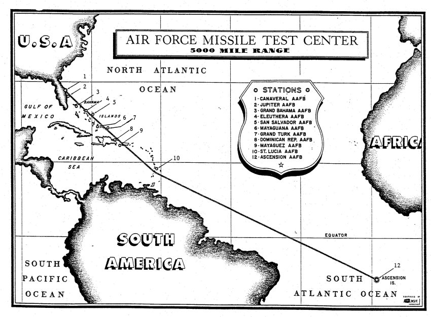
The range consists of a chain of shore and sea based tracking sites. "By January 1960, the Eastern Range included 13 major stations, approximately 91 outlying sites, a fleet of ships and three marine support stations. By September 1963, the Eastern Range extended around the tip of South Africa to the island of Mahé in the Indian Ocean.[11]" Much the sea based tracking and many of the land based stations have been replaced by space based tracking, including the present TDRSS. Ground stations associated with the range are located at:
- Cape Canaveral Air Force Station, Florida 28°29′03″N 080°34′21″W / 28.48417°N 80.5725°W
- John F. Kennedy Space Center, Florida
- Jupiter Auxiliary Air Force Base, Florida
- Now: Jonathan Dickinson Missile Tracking Annex (JDMTA)
- Located in Jonathan Dickinson State Park 26°58′57.6″N 080°06′29.7″W / 26.982667°N 80.10825°W [11]
- Antigua Auxiliary Air Force Base
- Located on the former Coolidge Air Force Base, St. Johns, Antigua
- Now: Antigua Air Station 17°08′14″N 061°46′33″W / 17.13722°N 61.77583°W
- Ascension Auxiliary Air Force Base
- Argentia, Newfoundland on the grounds of the decommissioned Argentia US Navy Facility (NAVFAC) which is manned on an "as needed" basis for northerly launches. 47°17′28″N 053°59′30″W / 47.29111°N 53.99167°W
[1]:pp 12–13
Major decommissioned stations associated with the range are located at:[12][13]
|
|
Launches supported by the range[]
Between 12/1/2008 and 12/1/2009 the Eastern Range supported 19 launches.[14]
| 2009-01-18 | Delta IV | 37B | NROL-26 |
| 2009-03-07 | Delta II | 17B | KEPLER |
| 2009-03-15 | Discovery | 39A | STS-119 |
| 2009-03-24 | Delta II | 17A | NAVSTAR IIR-20 |
| 2009-04-04 | Atlas V | 41 | WGS-2 |
| 2009-05-11 | Atlantis | 39A | STS-125 |
| 2009-05-26 | Trident II | S29 | DASO-9 |
| 2009-06-18 | Atlas V | 41 | LRO/LCROSS |
| 2009-06-27 | Delta IV | 37B | GOES-O |
| 2009-07-15 | Endeavour | 39A | STS-127 |
| 2009-08-17 | Delta II | 17A | NAVSTAR IIR-21 |
| 2009-08-29 | Discovery | 39A | STS-128 |
| 2009-09-03 | Trident II | SSBN-736 | FCET-41 |
| 2009-09-04 | Trident II | SSBN-736 | FCET-41 |
| 2009-09-08 | Atlas V | 41 | PAN |
| 2009-09-25 | Delta II | 17B | STSS DEMO |
| 2009-10-28 | Ares I-X | 39B | ARES I-X |
| 2009-11-16 | Atlantis | 39A | STS-129 |
| 2009-11-23 | Atlas V | 41 | INTELSAT-14 |
Airborne and sea-based tracking assets[]
As recently as 2007-07-06, NASA spacecraft such as Dawn have depended upon the availability of airborne and sea-based tracking assets[Clarification needed] associated with the ER to monitor launch and ascent.[15]
See also[]
- Ascension Island
- Cape Canaveral Air Force Station
- DAMP Project
- Missile Test Project
- Pacific Missile Range Facility
- Pan American Airways Guided Missile Range Division
- List of ships of the United States Air Force
- Western Launch and Test Range
- Missile Range Instrumentation Ship
References[]
- ↑ 1.0 1.1 1.2 1.3 1.4 1.5 1.6 1.7 Research Triangle Institute Center for Aerospace Technology (CAST) Florida Office (March 1999). "LAUNCH SITE SAFETY ASSESSMENT, SECTION 1.0 EASTERN RANGE GENERAL RANGE CAPABILITIES" (PDF). Federal Aviation Administration. http://www.fas.org/spp/military/facility/99mar_ccas_1.pdf. Retrieved 23 August 2008.
- ↑ "Eastern Range (U)". http://www.fas.org/spp/military/program/nssrm/initiatives/eastrang.htm. Retrieved 2008-02-10.
- ↑ 3.00 3.01 3.02 3.03 3.04 3.05 3.06 3.07 3.08 3.09 3.10 3.11 3.12 3.13 3.14 "Fact Sheets : EVOLUTION OF THE 45TH SPACE WING". http://www.patrick.af.mil/library/factsheets/factsheet.asp?id=4514. Retrieved 2008-06-02.
- ↑ 4.0 4.1 4.2 4.3 4.4 4.5 4.6 4.7 4.8 Lethbridge, Keith. "THE MISSILE RANGE TAKES SHAPE (1949-1958)". http://www.spaceline.org/capehistory/2a.html. Retrieved 2008-02-24.
- ↑ 5.0 5.1 5.2 5.3 5.4 5.5 5.6 "Chronology of work stoppages and related events, KSC NASA and AFETR through July 1965" (PDF). http://ntrs.nasa.gov/archive/nasa/casi.ntrs.nasa.gov/19670030427_1967030427.pdf. Retrieved 2008-08-23.
- ↑ 6.0 6.1 6.2 6.3 6.4 Lethbridge, Keith. "THE HISTORY OF CAPE CANAVERAL CHAPTER 3 NASA ARRIVES (1959-PRESENT)". http://www.spaceline.org/capehistory/3a.html. Retrieved 2009-08-23.
- ↑ 30th SW Public Affairs. "Space Vehicles : History Office : History Office". http://www.vandenberg.af.mil/library/factsheets/factsheet.asp?id=4606. Retrieved 2008-08-24.
- ↑ "VAFB". http://www.titan-ii.com/VAFB.html. Retrieved 2008-08-24.
- ↑ http://computersciencesraytheon.com/home.html CSR homepage
- ↑ 10.0 10.1 Mr. Loyd C. Parker; Mr. Jerry D. Watson Mr. James F. Stephenson (07 1989). "BASELINE ASSESSMENT WESTERN SPACE AND MISSILE CENTER" (PDF). RESEARCH TRIANGLE INSTITUTE CENTER FOR SYSTEMS ENGINEERING FLORIDA OFFICE for U.S. DEPARTMENT OF TRANSPORTATION OFFICE OF COMMERCIAL SPACE TRANSPORTATION. http://www.fas.org/spp/military/facility/western.pdf. Retrieved 2008-06-02.
- ↑ 11.0 11.1 "Fact Sheets : Development of the 45SW Eastern Range". http://www.patrick.af.mil/library/factsheets/factsheet.asp?id=4516. Retrieved 2008-01-12.
- ↑ Contractor operated USAF air bases Joe McCusker's list of Air Force Bases
- ↑ Air Force Missile Test Center Map (Historical)
- ↑ "Eastern Range Launch History". USAF. http://www.patrick.af.mil/shared/media/document/AFD-061027-008.pdf.
- ↑ "Dawn Launch Moves to No Earlier Than Monday July 9". NASA. 2007-07-06. http://www.nasa.gov/centers/kennedy/news/releases/2007/release-20070706.html.
External links[]
The original article can be found at Eastern Range and the edit history here.