The Battle of Leyte in the Pacific campaign of World War II was the amphibious invasion of the Gulf of Leyte in the Philippines by American and Filipino guerrilla forces under the command of General Douglas MacArthur, who fought against the Imperial Japanese Army in the Philippines led by General Tomoyuki Yamashita from 20 October - 31 December 1944. The operation code named King Two[4] launched the Philippines campaign of 1944–45 for the recapture and liberation of the entire Philippine Archipelago and to end almost three years of Japanese occupation. This was also the first battle in which the Japanese used kamikaze pilots.
Background[]
Japan had conquered the Philippines in 1942. It was vital for her survival in World War II to hold on to her conquest because it commanded the sea routes to Borneo and Sumatra by which rubber and petroleum were shipped to Japan.
For the US, capturing the Philippines was a key strategic step in isolating Imperial Japan's military holdings in China and the Pacific theater. It was also a personal matter of pride for MacArthur. In 1942, a month just before Japan forced the surrender of all USAFFE forces in the Philippines, US President Franklin D. Roosevelt had ordered MacArthur to leave the Philippines and organize the US forces gathering in Australia which were meant to relieve the USAFFE.
Those relief forces were non-existent and Roosevelt's true intentions in ordering MacArthur to flee the Philippines had been to prevent his capture by the Japanese. Even then, MacArthur had vowed that he would return to the Philippines. He repeatedly stated that it was a moral obligation of the US to liberate the Philippines as soon as possible.
From September to early October 1944, planes from the aircraft carriers of the US 3rd Fleet under Admiral William F. Halsey carried out successful missions. During the Palau and Morotai campaigns, they destroyed some 500 enemy aircraft and 180 seagoing merchant ships. These successful actions in the Philippines, Okinawa and Formosa (now Taiwan), indicated that an invasion of the Philippines itself was now feasible.
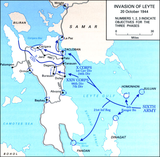
Invasion of Leyte Map, 20 October 1944
Leyte, one of the larger Philippine islands, has numerous deep-water approaches and sandy beaches which offered opportunities for amphibious assaults and fast resupply. The roads and lowlands extending inland from Highway 1, that ran for 40 mi (64 km) along the east coast between Abuyog town to the north and the San Juanico Strait between Leyte and Samar Islands, provided avenues for tank-infantry operations, as well as suitable ground for airfield construction. American air forces based on Leyte could strike at enemy bases and airfields anywhere in the archipelago.
A heavily-forested north-south mountain range dominates the interior and separates two sizable valleys, or coastal plains. The larger Leyte Valley extends from the northern coast to the long eastern shore and contains most of the towns and roadways on the island. The other, Ormoc Valley, situated on the west side, was connected to Leyte Valley by a roundabout and winding road, Highway 2; it ran from Palo town on the east coast, then west and northwest through Leyte Valley to the north coast, it then turned south and wound through a mountainous neck to enter the northern Ormoc Valley. This continued south to the port of Ormoc City, then along the western shore to Baybay town. The road then turned east to cross the mountainous waist of the island and it connected with Highway 1 on the east coast at Abuyog. Below these towns, the mountainous southern third of Leyte was mostly undeveloped. High mountain peaks over 4,400 ft (1,300 m), as well as the jagged outcroppings, ravines, and caves typical of volcanic islands offered formidable defensive opportunities. The timing late in the year of the assault would force combat troops and supporting pilots, as well as logistical units, to contend with monsoon rains.
Leyte's population of over 900,000 people—mostly farmers and fishermen—could be expected to assist an American invasion, since many residents already supported the guerrilla struggle against the Japanese in the face of harsh repression. Japanese troop strength on Leyte was estimated by US intelligence at 20,000; mostly of the 16th Division under Lieutenant General Shiro Makino.


Amphibious forces approach Leyte, October 1944
Battle[]
Landings[]
Preliminary operations for the Leyte invasion began at dawn on 17 October with minesweeping tasks and the movement of the 6th Rangers who were accompanied by one company from the 21st Infantry Regiment toward three small islands in Leyte Gulf. Although delayed by a storm, the Rangers were on Suluan and Dinagat islands by 12:30. On Suluan, they dispersed a small group of Japanese defenders and destroyed a radio station, while they found Dinagat unoccupied. On both, the Rangers proceeded to erect navigation lights for the amphibious transports to follow three days later. The next day, the third island Homonhon, was taken without any opposition. Meanwhile reconnaissance by underwater demolition teams revealed clear landing beaches for assault troops on Leyte.
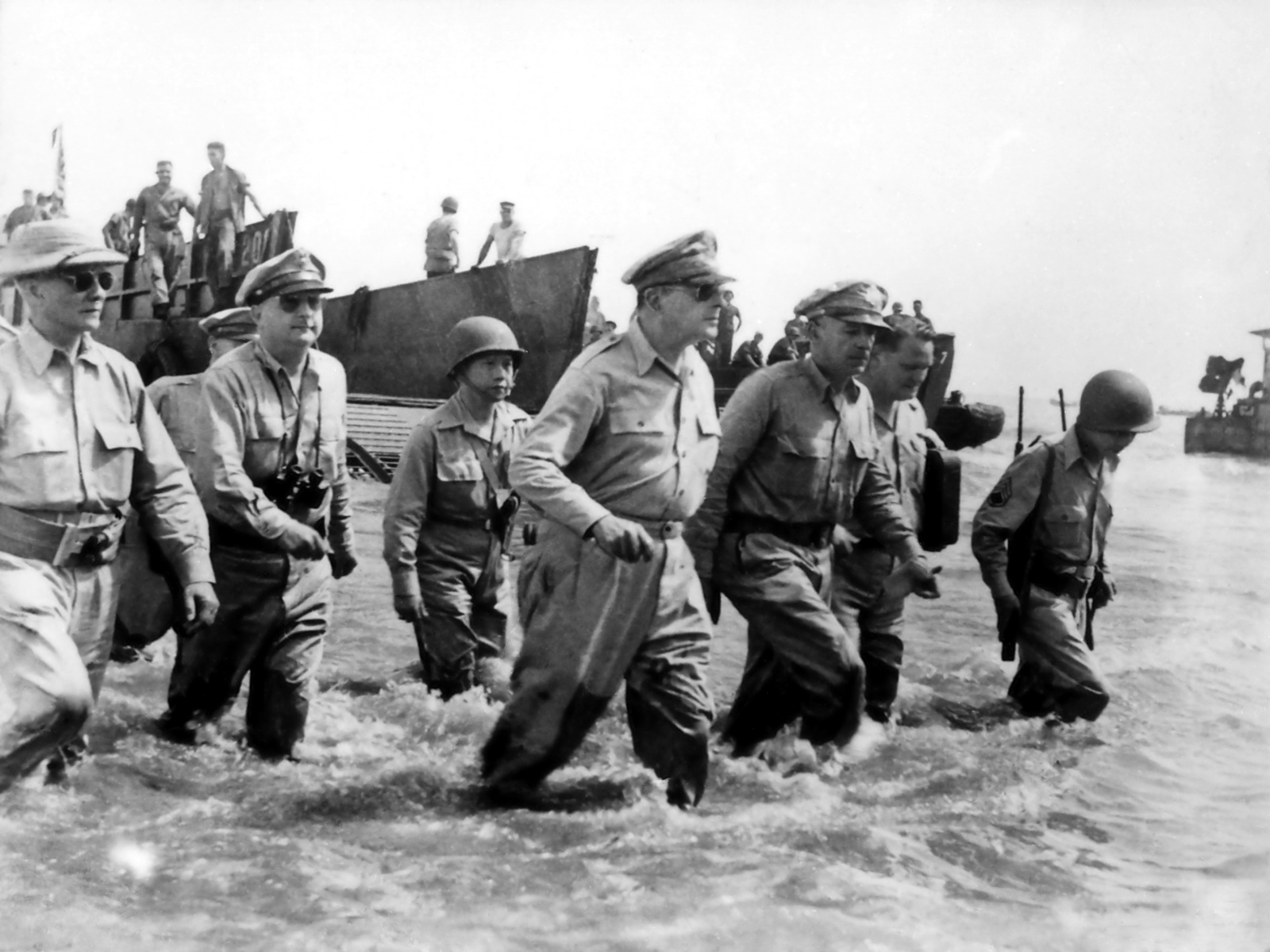
Following four hours of heavy naval gunfire on A-day, 20 October, Sixth Army forces landed on assigned beaches at 10:00. X Corps pushed across a 4 mi (6.4 km) stretch of beach between Tacloban airfield and the Palo River. 15 mi (24 km) to the south, XXIV Corps units came ashore across a 3 mi (4.8 km) strand between San José and the Daguitan River. Troops found as much resistance from swampy terrain as from Japanese fire. Within an hour of landing, units in most sectors had secured beachheads deep enough to receive heavy vehicles and large amounts of supplies. Only in the 24th Division sector did enemy fire force a diversion of follow-up landing craft. But even that sector was secure enough by 13:30 to allow Gen. MacArthur to make a dramatic entrance[5] through the surf and announce to the populace the beginning of their liberation: "People of the Philippines, I have returned! By the grace of Almighty God, our forces stand again on Philippine soil."


US 1st Cavalry troops wade through a swamp in Leyte
By the end of A-day, the Sixth Army had moved 2 mi (3.2 km) inland and controlled Panaon Strait at the southern end of Leyte. In the X Corps sector, the 1st Cavalry Division held Tacloban airfield, and the 24th Infantry Division had taken the high ground on Hill 522 commanding its beachheads. In the XXIV Corps sector, the 96th Infantry Division held the approaches to Catmon Hill. The 7th Infantry Division took the town of Dulag, which forced Gen. Makino to move his command post 10 mi (16 km) inland to the town of Dagami. The initial fighting was won at a cost of 49 killed, 192 wounded, and six missing.
Campaign in Southern Leyte Valley[]
The Sixth Army made steady progress inland against sporadic and uncoordinated enemy resistance on Leyte in the next few days. The 1st Cavalry Division of Maj. Gen. Verne D. Mudge secured the provincial capital, Tacloban, on 21 October. On 23 October, Gen. MacArthur presided over a ceremony to restore civil government to Leyte. 1st and 2nd Cavalry Brigades initiated a holding action to prevent a Japanese counterattack from the mountainous interior, after which the 1st Cavalry was allowed to move on.


US infantrymen move cautiously toward a machinegun nest
On the X Corps left, the 24th Infantry Division under Maj. Gen. Frederick A. Irving, drove inland into heavy enemy resistance. After days and nights of hard fighting and killing some 800 Japanese, the 19th and 34th Infantry Regiments expanded their beachhead and took control of the high ground commanding the entrance to the northern Leyte Valley. By 1 November, after a seven-day tank-infantry advance supported by artillery fire, both regiments had pushed through Leyte Valley and were within sight of the north coast and the port of Carigara. The next day, the 2nd Cavalry Brigade captured Carigara. In its drive through Leyte Valley, the 24th Division inflicted nearly 3,000 enemy casualties. These advances left only one major port on Leyte—Ormoc City on the west coast—under Japanese control.


A US 105 mm (4.1 in) howitzer fires at Catmon Hill
From the XXIV Corps beachhead Gen. Hodge had sent his two divisions into the southern Leyte Valley, which already contained four airfields and a large supply center. Maj. Gen. James L. Bradley's 96th Infantry Division was to clear Catmon Hill, a 1,400 ft (430 m) promontory, the highest point in both corps beachheads, and used by the Japanese as an observation and firing post to fire on landing craft approaching the beach on A-day. Under cover of incessant artillery and naval gunfire, Bradley's troops made their way through the swamps south and west of the high ground at Labiranan Head. After a three-day fight, the 382nd Infantry Regiment took a key Japanese supply base at Tabontabon, 5 mi (8.0 km) inland, and killed some 350 Japanese on 28 October. Simultaneously two battalions each from the 381st and 383rd Infantry Regiments slowly advanced up opposite sides of Catmon Hill and battled the fierce Japanese resistance. When the mop-up of Catmon Hill was completed on 31 October, the Americans had cleared 53 pillboxes, 17 caves, and several heavy artillery positions.

US armored car at Labiranan Head
On the left of XXIV Corps, the 7th Infantry Division under Maj. Gen. Archibald V. Arnold moved inland against four Japanese airfields between the small towns of Dulag and Burauen. On 21 October, the 184th Infantry took Dulag airfield, while the 32nd Infantry Regiment cleared both sides of the Calbasag River. The bloody fight for the airfields and village was decided by flying wedges of American tanks which cleared the way for the infantrymen. At Burauen, the 17th Infantry overcame fanatical but futile resistance from Japanese spider holes and suicidal attacks to stop the American tanks by holding explosives against their armored hulls. A mile north, 32nd Infantry soldiers killed more than 400 Japanese at Buri airfield. While two battalions of the 184th Infantry patrolled the corps' left flank, the 17th Infantry, with the 184th's 2nd Battalion attached, turned north toward Dagami, 6 mi (9.7 km) above Burauen. Using flamethrowers to root the enemy out of pillboxes and a cemetery, US troops captured Dagami on 30 October, which forced Gen. Makino to evacuate his command post further westward. Meanwhile, on 29 October, the 32nd Infantry's 2nd Battalion, preceded by the 7th Cavalry Reconnaissance Troop, moved 15 mi (24 km) south along the east coast to Abuyog for a probe of the area, and then over the next four days patrolled west through the mountains to bring Ormoc Bay under observation, all without opposition.
Japanese counterattacks[]
As the Sixth Army pushed deeper into Leyte, the Japanese struck back in the air and at sea. On 24 October, some 150 to 200 enemy aircraft approached American beachheads and shipping from the north. Fifty American land-based aircraft rose to intercept them, and claimed to have shot down between 66 and 84 of the attackers. Day and night air raids continued over the next four days, damaging supply dumps ashore and threatening American shipping. But by 28 October, counterattacks by US aircraft on Japanese airfields and shipping on other islands so reduced enemy air strength that conventional air raids ceased to be a major threat. As their air strength diminished, the Japanese resorted to the deadly kamikazes, a corps of suicide pilots who crashed their bomb-laden planes directly into US ships. They chose the large American transport and escort fleet that had gathered in Leyte Gulf on A-day as their first target and sank one escort carrier and badly damaged many other vessels.

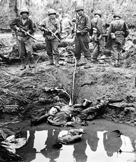
Four Japanese snipers shot and killed in the muddy water of a bomb crater
A more serious danger to the US forces developed at sea. The Imperial Japanese Navy's high command decided to destroy US Navy forces supporting the Sixth Army by committing its entire remaining surface fleet to a decisive battle with the Americans. The Imperial Navy's plan was to attack in three major task groups. One, which included four aircraft carriers with few aircraft aboard, was to act as a decoy, luring the US 3rd Fleet north away from Leyte Gulf. If the decoy was successful, the other two groups, consisting primarily of heavy surface combatants, would enter the gulf from the west and attack the American transports.


A US anti-aircraft gun at Tacloban airfield in action
On 23 October, the approach of the enemy surface vessels was detected. US naval units moved out to intercept, and the air and naval Battle of Leyte Gulf—the largest naval battle in the Pacific and also one of the largest naval battles in history[6]—was fought from 23-26 October—the Japanese suffered a decisive defeat. Nonetheless by 11 December, the Japanese had succeeded in moving more than 34,000 troops to Leyte and over 10,000 short tons (9,100 t) of materiél, most through the port of Ormoc on the west coast, despite heavy losses to reinforcement convoys, including engagements at Ormoc Bay, because of relentless air interdiction missions by US aircraft.
Advance into northern Leyte Valley[]
The Japanese reinforcement presented severe problems for both Krueger and MacArthur. Instead of projected mopping up operations after clearing the east side of Leyte, the Sixth Army had to prepare for extended combat in the mountains on its western side, which included landing three reserve divisions on Leyte, this pushed MacArthur's operations schedule for the Philippine campaign back and the War Department's deployment plans in the Pacific.
The 1st Cavalry and 24th Infantry Divisions linked up at Carigara on 2 November highlighted the successful opening drive of the campaign. After 17 days of combat operations, the Sixth Army had all of its first and second phase objectives under control, as well as one third-phase objective, Abuyog. In addition, elements of the 7th Division had pushed across the island from the southern end of the XXIV Corps sector and controlled approaches to the town of Baybay on the west coast. Only one key area, Ormoc Valley on the west side of the island, remained to be taken.
To clear Ormoc Valley, Gen. Krueger planned a giant pincer operation, with X Corps forces moving south through the mountains and XXIV Corps units pushing north along the western shore. To overcome the expected increased resistance, especially in the mountain barrier to the north, Krueger mobilized his reserve forces, the 32nd and 77th Infantry Divisions, while MacArthur activated the 11th Airborne Division. The 21st RCT pulled out from the Panaon area to rejoin the 24th Division and were replaced by a battalion of the 32nd Infantry. On 3 November, the 34th Infantry Regiment moved out from west of Carigara to sweep the rest of the northern coast before turning south into the mountains. The 1st Battalion soon came under attack from a ridge along the highway. Supported by the 63rd Field Artillery Battalion, the unit cleared the ridge, and the 34th Infantry continued unopposed that night through the town of Pinamopoan, recovering numerous heavy weapons abandoned by the enemy, then halted at the point where Highway 2 turns south into the mountains.
Battles of 'Breakneck' and Kilay Ridges[]
On 7 November the 21st Infantry went into its first sustained combat on Leyte when it moved into the mountains along Highway 2, near Carigara Bay. The fresh regiment, with the 19th Infantry's 3rd Battalion attached, immediately ran into strong defenses of the newly arrived Japanese 1st Division, aligned from east to west across the road and anchored on a network of fighting positions built of heavy logs and interconnecting trench lines and countless spider holes, which became known as 'Breakneck Ridge'.
A typhoon began on 8 November, and the heavy rain that followed for several days further impeded American progress. Despite the storm and high winds, which added falling trees and mud slides to enemy defenses and delayed supply trains, the 21st Infantry continued its slow and halting attack, with companies often having to withdraw and recapture hills that had been taken earlier. The Americans seized the approaches to Hill 1525 2 mi (3.2 km) to the east, enabling Irving to stretch out the enemy defenses further across a 4 mi (6.4 km) front along Highway 2.
Five days of battling against seemingly impregnable hill positions and two nights of repulsing enemy counterattacks proved fruitless, so Irving decided on a double envelopment of the enemy defenders. The 19th Infantry's 2nd Battalion swung east around Hill 1525 behind the enemy right flank, cutting back to Highway 2, 3 mi (4.8 km) south of 'Breakneck Ridge'. To take the left flank to the west, Irving sent the 34th Infantry's 1st Battalion under Lt. Col. Thomas E. Clifford, over water from the Carigara area to a point 2 mi (3.2 km) west of the southward turn of Highway 2 and moved it inland. This amphibious maneuver was made in eighteen LVTs of the 727th Amphibian Tractor Battalion.[7] After crossing a ridge line and the Leyte River, they approached the enemy left flank at 900 ft (270 m) on Kilay Ridge, the highest terrain behind the main battle area. Both battalions reached positions only about 1,000 yd (910 m) apart on opposite sides of the highway by 13 November despite strong opposition and heavy rains. Clifford's battalion promptly attacked Kilay Ridge on the west, while the 2nd Battalion assaulted a hill on the east side. Neither unit achieved their objectives.


Filipino volunteers carry supplies to the 12th Cavalry Brigade
It took Clifford's men two weeks of struggle through mud and rain—often dangerously close to friendly mortar and artillery fire—to root the Japanese out of fighting positions on the way up Kilay Ridge. On 2 December Clifford's battalion finally cleared the heights overlooking the road, and 32nd Division units quickly took over. Clifford's outfit suffered 26 killed, 101 wounded and two missing, in contrast to 900 Japanese dead. For their arduous efforts against Kilay Ridge and adjacent areas, both flanking battalions received Presidential Unit Citations. Clifford received the Distinguished Service Cross for the action. It was not until 14 December that the 1st Cavalry Division and the 32nd Division finally cleared the Breakneck–Kilay Ridge area, placing the most heavily defended portions of Highway 2 between Carigara Bay and the Ormoc Valley under X Corps control.
Throughout this phase, American efforts had become increasingly hampered by logistical problems. Mountainous terrain and impassable roads forced Sixth Army transportation units to improvise resupply trains of Navy landing craft, tracked landing vehicles, airdrops, artillery tractors, trucks, even carabaos and hundreds of barefoot Filipino bearers. The 727th Amphibian Tractor Battalion made daily, often multiple, trips with ammunition and rations between Capoocan and Calubian. From Calubian, the 727th tractors would navigate the Naga River to Consuegra and then traverse overland to Agahang. On their return trip, they would evacuate the casualties. Not surprisingly, the complex scheduling slowed resupply as well as the pace of assaults, particularly in the mountains north and east of Ormoc Valley and subsequently in the ridgelines along Ormoc Bay.
Drive through Ormoc Valley[]
With X Corps making headway through the northern mountains, XXIV Corps struggled to muster forces around Baybay for the northern drive up the western Ormoc Valley coast. By mid-November XXIV Corps still had only the 32nd Infantry Regiment in western Leyte, with 7th Division remnants still securing Burauen. Only the arrival of the 11th Airborne Division in strength around 22 November finally made Gen. Hodge allow the entire 7th Division to move to the west. On the night of 23 November, the 32nd Infantry suddenly came under attack by the Japanese 26th Division. The regiment's 2nd Battalion was pushed back, but they regained lost ground the next day. Gen. Arnold ordered his units to dig-in and attached the 1st Battalion, 184th Infantry, to the 32nd Infantry, including reinforcements from the 767th Tank Battalion, the 49th Field Artillery Battalion, and a Marine Corps 155 mm (6.1 in) battery from the cancelled Yap operation. Pummeled by heavy fire from these artillery units, the Japanese concentrated on them on the night of 24 November, and put four 105 mm (4.1 in) pieces out of action. The 57th Field Artillery Battalion reinforced them the next day, giving the 7th Division five additional batteries to support what had become a major defensive effort. The battle for 'Shoestring Ridge' continued, as the Japanese mounted two more attacks on consecutive nights despite heavy casualties. Not until 27 November were US troops able to take the offensive, with some 500 enemy dead and 29 abandoned machine guns outside and within the defensive perimeter discovered during their northern advance.
Gen. Arnold finally began his advance toward Ormoc with a novel tactic. On the night of 4 December, vehicles of the 776th Amphibian Tank Battalion put to sea and leapfrogged north along the coast 1,000 yd (910 m) ahead of the ground units. The next morning, the tanks moved to within 200 yd (180 m) of the shore and fired into the hills in front of the advancing 17th and 184th Infantry. This tactic proved effective, greatly disorganizing the defenders, except where ground troops encountered enemy pockets on reverse slopes inland, shielded from the offshore tank fire. The 7th Division pushed north with two regiments which encountered heavy enemy fire coming from Hill 918, from which the entire coast to Ormoc City could be observed. Two days of intense fighting against enemy units enabled the 17th and 184th regiments to clear the strongpoint, after which the advance accelerated. By 12 December, Gen. Arnold's lead battalion was less than 10 mi (16 km) south of Ormoc City.
Fall of Ormoc[]
While Gen. Arnold moved closer to Ormoc, the Japanese made a surprise attack on the Burauen airfields with the 16th and 26th Divisions in the central mountains, combined with the 3rd and 4th Airborne Raiding Regiments from Luzon. Some 350 Japanese paratroopers dropped at dusk on 6 December, mostly near the San Pablo airstrip. Although poorly coordinated, the enemy attack yielded the seizure of some abandoned weapons which they managed to use against the Americans over the next four days. Hastily mustered groups of support and service troops of the 7th Division held off the Japanese until reinforcements from the 11th Airborne and 38th Infantry Division, concentrated enough strength to contain and defeat the enemy paratroopers by nightfall of 11 December. With a few American supply dumps and aircraft on the ground destroyed and construction projects delayed, the enemy attacks on the airfields failed to have any effect on the overall Leyte Campaign.


Situation at Leyte, 7 November-31 December 1944
Meanwhile, on the western side of Leyte, the XXIV Corps received reinforcements on 7 December with the landing of the 77th Infantry Division under Maj. Gen. Andrew D. Bruce south of Ormoc City. The 77th Division's 305th, 306th, and 307th Infantry Regiments came ashore unopposed although naval shipping was subjected to kamikaze air attacks. The arrival of the 77th Division proved decisive. This enabled the 7th Division to resume its march north, and the enemy defenders were quickly squeezed between the two forces. Gen. Suzuki ordered the Burauen task force to disengage and cross the mountains to help hold Ormoc Valley. Only small groups of these exhausted and malnourished troops reached the west coast in time to be of any great use.
The 77th Division faced strong opposition at Camp Downes, a prewar Philippine constabulary post. Supported by the 305th and 902nd Field Artillery Battalions, Gen. Bruce's troops pushed through and beyond Camp Downes to enter Ormoc City on 10 December, and in its final drive, US troops killed some 1,506 enemy and took seven prisoners while sustaining 123 killed or wounded and 13 missing. With Ormoc City captured, the XXIV Corps and X Corps were only 16 mi (26 km) apart. In between, the last enemy salient with its defenses anchored on a blockhouse, north of Ormoc, and held by the 12th Independent Infantry Regiment, resisted the Americans for two days. On 14 December, the 305th Infantry closed on the stronghold, aided by heavy artillery barrages and employing flamethrowers and armored bulldozers. Hand-to-hand combat and the inspiring leadership of Medal of Honor awardee Captain Robert B. Nett cleared the enemy from the blockhouse area, while the leading Company, E, of the 2nd Battalion, 305th Infantry moved forward through intense fire and killed several Japanese soldiers.
Westward march to the coast[]
After breaking out of Ormoc, the 77th Division took Valencia airfield, 7 mi (11 km) north, on 18 December, and continued north to establish contact with X Corps units. That same day, Gen. Sibert ordered the 1st Cavalry Division to complete the drive south. The 12th Cavalry Regiment pushed out of the mountains on a southwest track to Highway 2, then followed fire from the 271st Field Artillery Battalion to clear a 3 mi (4.8 km) stretch of the road. North of Ormoc Valley, the 32nd Division had met continued determined opposition from the defending Japanese 1st Division along Highway 2, after moving south past Kilay Ridge and entering a heavy rain forest, which limited visibility and concealed the enemy. Using flamethrowers, hand grenades, rifles, and bayonets, troops scratched out daily advances measured in yards, and in five days of hard fighting, the 126th and 127th Infantry Regiments advanced less than 1 mi (1.6 km). Contact between patrols of the 12th Cavalry and the 77th Division's 306th Infantry on 21 December marked the juncture of the US X and XXIV Corps and the closing of the Sixth Army's pincer maneuver against Ormoc Valley.
While the 77th and 32nd Divisions converged on the valley, Maj. Gen. Joseph M. Swing's 11th Airborne Division had moved into the central mountain passes from the east. With blocking positions established south of Leyte Valley on 22–24 November, the 511th Parachute Infantry Regiment pushed farther west into the mountains on the 25 November. After an arduous advance, the 511th reached Mahonag, 10 mi (16 km) west of Burauen, on 6 December, the same day Japanese paratroops landed at the Buri and San Pablo airfields. On 16 December, the 2nd Battalion, 32nd Infantry, made slow but steady progress into the mountains from the Ormoc Bay area to meet the airborne regiment and assist its passage westward. On 23 December, after battling scattered Japanese defenders on ridges and in caves, the 7th Division infantrymen met troops from the 2nd Battalion, 187th Glider Infantry Regiment, which had passed through the 511th, to complete the cross-island move.
Gen. Bruce opened the drive on Palompon by sending the 2nd and 3rd Battalions, 305th Infantry, with armor support, west along the road on the morning of 22 December. The 302nd Engineer Battalion followed, repairing and strengthening bridges for armor, artillery and supply vehicles. Assault units progressed rapidly through sporadic enemy fire until they hit strong positions about 8 mi (13 km) short of Palompon. To restore momentum, Gen. Bruce put the 1st Battalion, 305th Infantry, on Navy landing craft and dispatched it from the port of Ormoc to Palompon. Supported by fire from mortar boats of the 2nd Engineer Special Brigade and from the 155 mm (6.1 in) guns of the 531st Field Artillery Battalion, the infantrymen landed at 07:20 on 25 December and secured the small coastal town within four hours.
Learning of the seizure of the last port open to the Japanese, Gen. MacArthur announced the end of organized resistance on Leyte. As these sweeps continued, he transferred control of operations on Leyte and Samar to the Eighth Army on 26 December. Farther north, other US forces made faster progress against more disorganized and dispirited enemy troops. 1st Cavalry Division troops reached the coast on 28 December as 24th Division units cleared the last enemy positions from the northwest corner of Leyte on the same day and two days later met patrols of the 32nd Division. But Japanese defenders continued to fight as units until 31 December, and the ensuing mop-up of stragglers continued until 8 May 1945.
Aftermath[]
The campaign for Leyte proved the first and most decisive operation in the American reconquest of the Philippines, and it cost American forces a total of 15,584 casualties, of which 3,504 were killed in action. Nor were the Americans the only Allied forces to suffer losses; Australian casualties include 30 dead and 64 wounded when a Japanese kamikaze plane crashed into the heavy cruiser HMAS Australia during the gulf battle.
The Japanese lost an estimated 49,000 combat troops in their failed defense of Leyte. Their losses in the campaign were heavy, with the army losing four divisions and several separate combat units, while the navy lost 26 major warships and 46 large transports and hundreds of merchantmen. The struggle also reduced Japanese land-based air capability in the Philippines by more than 50%, forcing them to depend on kamikaze pilots. Some 250,000 troops still remained on Luzon, but the loss of air and naval support at Leyte so narrowed Gen. Yamashita's options that he now had to fight a defensive, almost passive, battle of attrition on Luzon, the largest and most important island in the Philippines. In effect, once the decisive battle of Leyte was lost, the Japanese gave up hope of retaining the Philippines, conceding to the Allies in the process a critical bastion from which Japan could be easily cut off from outside resources, and from which the final assaults on the Japanese home islands could be launched.
References[]
![]() This article incorporates public domain material from the United States Army Center of Military History document "The Leyte Campaign".
This article incorporates public domain material from the United States Army Center of Military History document "The Leyte Campaign".
- Drea, Edward J. (1998). "Leyte: Unanswered Questions". In the Service of the Emperor: Essays on the Imperial Japanese Army. Nebraska: University of Nebraska Press. ISBN 0-8032-1708-0.
- History of United States Naval Operations in World War II. Vol. 13: The Liberation of the Philippines—Luzon, Mindanao, the Visayas, 1944-1945 by Samuel Eliot Morison (2002) University of Illinois Press, ISBN 0-252-07064-X
- Battle for Leyte, 1944: Allied And Japanese Plans, Preparations, And Execution by Milan N. Vego (2006) Naval Institute Press, ISBN 1-55750-885-2
- World War II in the Pacific: An Encyclopedia (Military History of the United States) by S. Sandler (2000) Routledge, ISBN 0-8153-1883-9
- ↑ http://www.generals.dk/general/Makino/Shiro/Japan.html
- ↑ http://www.j-aircraft.com/faq/japanese_paratroop_operations_in.htm
- ↑ http://www.generals.dk/general/Adachi/Yoshimi/Japan.html
- ↑ Cutler, Thomas J., The Battle of Leyte Gulf: 23–26 October 1944, Naval Institute Press, 2001, p.52
- ↑ "Video: Third Army blasts Nazi Strongholds, 1944/11/02 (1944)". Universal Newsreel. 1944. http://www.archive.org/details/1944-11-02_3rd_Army_blasts_Nazi_Strongholds. Retrieved February 21, 2012.
- ↑ Woodward, C. Vann (1947). The Battle for Leyte Gulf. New York: Macmillan.
- ↑ Journal, 727th Amphibian Tractor Battalion, 6 Nov 1944 to 10 Nov 1944
External links[]
| Wikimedia Commons has media related to Battle of Leyte. |
- Ibiblio.Org: U.S. Army Campaigns of World War II, Leyte
- Battleship.Org: Battle of Leyte
- Soldiers of the 184th Infantry, 7th ID in the Pacific, 1943–1945
- U.S. Intelligence Report on Japanese Use of Mines on Leyte
- MacArthur Landing Memorial Park (Red Beach, Palo, Leyte, Philippines)
Coordinates: 10°57′N 124°50′E / 10.95°N 124.833°E
The original article can be found at Battle of Leyte and the edit history here.