The Battle of South Mountain—known in several early Southern accounts as the Battle of Boonsboro Gap—was fought September 14, 1862, as part of the Maryland Campaign of the American Civil War. Three pitched battles were fought for possession of three South Mountain passes: Crampton's, Turner's, and Fox's Gaps. Maj. Gen. George B. McClellan, commanding the Union Army of the Potomac, needed to pass through these gaps in his pursuit of Confederate General Robert E. Lee's Army of Northern Virginia. Despite being significantly outnumbered, Lee's army delayed McClellan's advance for a day before withdrawing.
Background
South Mountain is the name given to the continuation of the Blue Ridge Mountains after they enter Maryland. It is a natural obstacle that separates the Hagerstown Valley and Cumberland Valley from the eastern part of Maryland.
After Lee invaded Maryland, a copy of an order, known as order 191, detailing troop movements that he wrote fell into the hands of McClellan. From this, McClellan learned that Lee had split his forces and the Union general hoped to attack and defeat some of these isolated forces before they could concentrate against him. To reach Lee, McClellan had to move across South Mountain. Lee learned of McClellan's intelligence coup and quickly sent forces to reinforce the passes to block his advance.
McClellan temporarily organized his army into three wings for the attacks on the passes. Maj. Gen. Ambrose Burnside, the Right Wing, commanded the I Corps (Maj. Gen. Joseph Hooker) and IX Corps (Maj. Gen. Jesse L. Reno). The Right Wing was sent to Turner's Gap and Fox's Gap in the north. The Left Wing, commanded by Maj. Gen. William B. Franklin, consisting of his own VI Corps and Maj. Gen. Darius N. Couch's division of the IV Corps, was sent to Crampton's Gap in the south. The Center Wing (II Corps and XII Corps), under Maj. Gen. Edwin V. Sumner, was in reserve.
Battles
Crampton's Gap
At the southernmost point of the battle, near Burkittsville, Confederate cavalry and a small portion of Maj. Gen. Lafayette McLaws's division defended Brownsville Pass and Crampton's Gap. McLaws was unaware of the approach of 12,000 Federals and had only 500 men under Col. William A. Parham thinly deployed behind a three quarter-mile-long stone wall at the eastern base of Crampton's Gap. Franklin spent three hours deploying his forces. A Confederate later wrote of a "lion making exceedingly careful preparations to spring on a plucky little mouse." Franklin deployed the division of Maj. Gen. Henry W. Slocum on the right and Maj. Gen. William F. "Baldy" Smith on the left. They seized the gap and captured 400 prisoners, mostly men who were arriving as late reinforcements from Brig. Gen. Howell Cobb's brigade.[1]
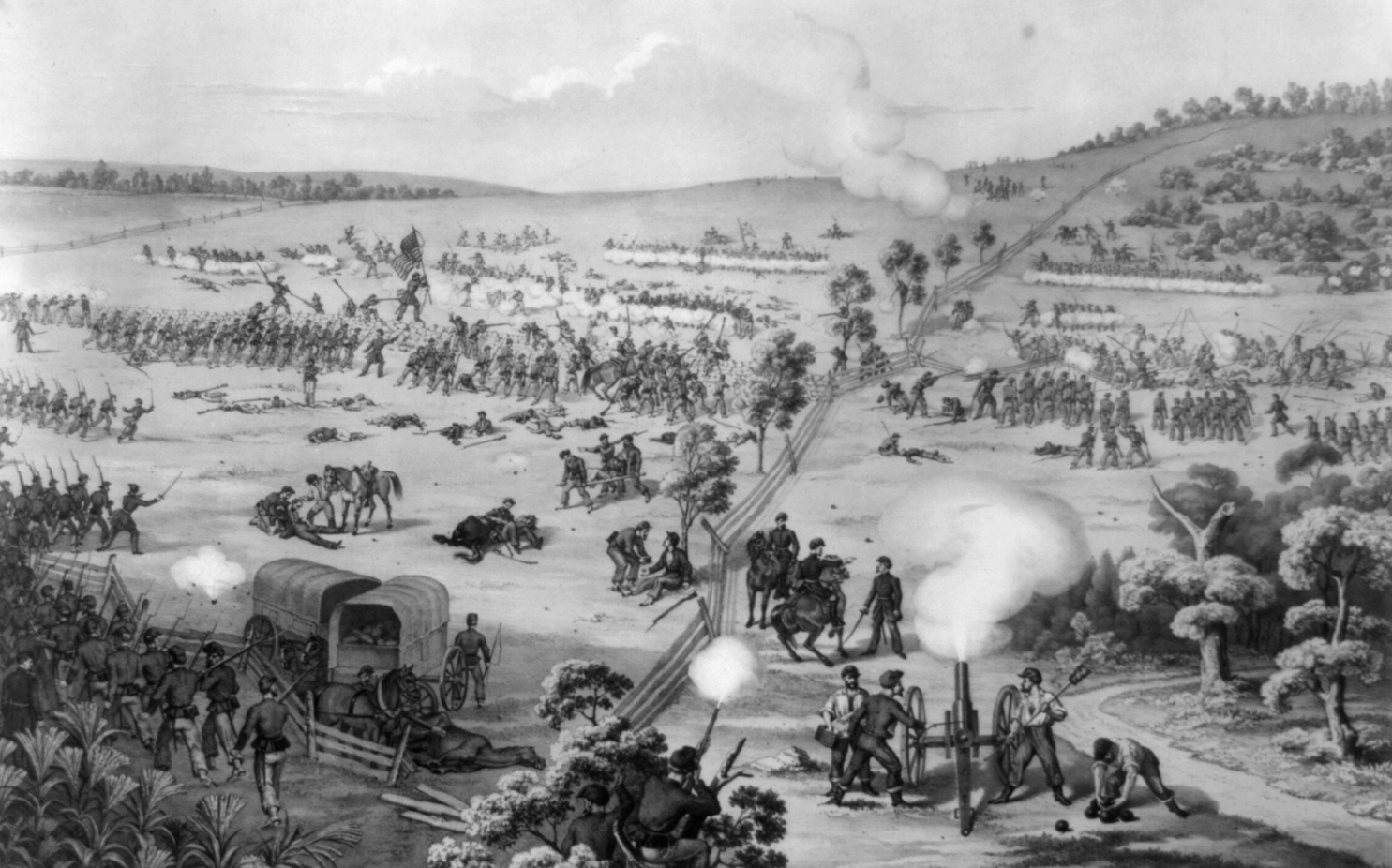
Turner's Gap


Northern field of battle
Confederate Maj. Gen. D.H. Hill, deploying 5,000 men over more than 2 miles, defended both Turner's Gap and Fox's Gap. Burnside sent Hooker's I Corps to the right and Turner's Gap. The Union Iron Brigade attacked Colonel Alfred H. Colquitt's brigade along the National Road, driving it back up the mountain, but it refused to yield the pass. Hooker positioned three divisions opposite two peaks located one mile north of the gap. The Alabama Brigade of Brig. Gen. Robert E. Rodes was forced to withdraw because of his isolated position, despite the arrival of reinforcements from Brig. Gen. David R. Jones's division and Brig. Gen. Nathan G. Evans's brigade. Darkness and the difficult terrain prevented the complete collapse of Lee's line. At nightfall, the Federals held the high ground while[2] the Confederates still held the gap.[1][3]
Fox's Gap
Just to the south, other elements of Hill's division (most notably Drayton's Brigade [4]) defended Fox's Gap against Reno's IX Corps. A 9 a.m. attack by Union Brig. Gen. Jacob D. Cox's Kanawha Division secured much of the land south of the gap. In the movement, Lt. Col. Rutherford B. Hayes of the 23rd Ohio led a flank attack and was seriously wounded. Cox pushed through the North Carolinians positioned behind a stone wall at the gap's crest, but he failed to capitalize on his gains as his men were exhausted, allowing Confederate reinforcements to deploy in the gap around the Daniel Wise farm. Reno sent forward the rest of his corps, but due to the timely arrival of Southern reinforcements under Confederate Brig. Gen. John Bell Hood, they failed to dislodge the defenders. Union Maj. Gen. Jesse Reno and Confederate Brig. Gen. Samuel Garland, Jr., were killed at Fox's Gap. Union soldiers dumped 60 Confederate bodies down Farmer Wise's dry well, paying him $60 in compensation.[5][6][7]
Aftermath
By dusk, with Crampton's Gap lost and his position at Fox's and Turner's Gaps precarious, Lee ordered his outnumbered forces to withdraw from South Mountain. McClellan was now in position to destroy Lee's army before it could concentrate. Union casualties of 28,000 engaged were 2,325 (443 killed, 1,807 wounded, and 75 missing); Confederates lost 2,685 (325 killed, 1560 wounded, and 800 missing) of 18,000.[5] The Battle of South Mountain was an important morale booster for the defeat-stricken Army of the Potomac. The New York World wrote that the battle "turn[ed] back the tide of rebel successes" and "the strength of the rebels is hopelessly broken."[8] Lee contemplated the end of his Maryland campaign. However, McClellan's limited activity on September 15 after his victory at South Mountain condemned the garrison at Harpers Ferry to capture[9] and gave Lee time to unite his scattered divisions at Sharpsburg for the Battle of Antietam on September 17.[10]
The battlefields are preserved within the South Mountain State Park, Gathland State Park, and the Appalachian National Scenic Trail. Crampton's Gap Historic District and Turner's and Fox's Gaps Historic District are listed on the National Register of Historic Places.[11]
Battlefield preservation
The Civil War Trust, a prominent battlefield preservation group, has preserved 188 acres of land at the center of where the fighting took place in 1862. Most of the preserved area sits west of Route 40 south of where the old Sharpsburg Road (now known as Reno Monument Road) meets Fox’s Gap Road. 18 acres were originally acquired by the Trust in 1991, to which 8 acres were added in 1995. More gains followed, as 136 acres were preserved in 2000, followed by 26 in 2004. Many of these additions were made with the assistance of the Maryland Environmental Trust.[12]
In January 2011, the South Mountain battlefield gained National Heritage Landmark status and in August 2012, the State of Maryland declared its continued commitment to the preservation of these invaluable lands. The Civil War Trust followed these developments with a campaign to save 14 additional acres at the site.[13] However, nearby heritage areas in Frederick and Washington counties are still threatened by development and South Mountain was listed as one of the Most Endangered Battlefields in the 2009 and 2010 editions of History Under Siege. Plans to further develop the site of a natural gas plant just south of Fox’s Gap remain a significant threat to portions of the South Mountain battlefield.[14]
Future presidents
Two future presidents, Rutherford B. Hayes[15][16] and William McKinley,[17][18] fought at Fox's Gap during the Battle of South Mountain, as part of the 23rd Ohio Infantry—Hayes as its commander, and McKinley a commissary sergeant. Hayes would end the war as a brevet major general and McKinley a brevet major, and they would be elected to the presidency twenty years apart—Hayes in 1876, and McKinley in 1896.
See also
Notes
- ↑ 1.0 1.1 Kennedy, p. 117.
- ↑ Antietam on the Web
- ↑ General D. H. Hill's report of his operations at this time is included in the Official Records, Series I, Vol. 19, pp. 1019-1022.
- ↑ lost Confederate Legion: Phillips Legion infantry at Fox's Gap, The | Military Images | Find Articles at BNET
- ↑ 5.0 5.1 Eicher, p. 344.
- ↑ They were reburied at Washington Confederate Cemetery in 1877. See Friends of South Mountain
- ↑ Battles and Leaders of the Civil War Volume 2 .p.573 and 583
- ↑ McPherson, p. 112.
- ↑ Sears, McClellan, p. 292; McPherson, p. 112.
- ↑ Sears, Landscape, p. 149.
- ↑ "National Register Information System". National Register of Historic Places. National Park Service. 2008-04-15. http://nrhp.focus.nps.gov/natreg/docs/All_Data.html.
- ↑ "South Mountain Battlefield Facts," Civil War Trust
- ↑ "Special Announcement," Friends of South Mountain State Battlefield, January 2011
- ↑ "Gettysburg Again Among Most Endangered Sites," Washington Post, March 2009
- ↑ "Rutherford Birchard Hayes". University of Virginia's Miller Center. http://millercenter.org/president/hayes/essays/biography/2. Retrieved 24 June 2012.
- ↑ Keating, Dennis (2007). "Three Ohio Civil War Veterans Who Became President". Cleveland Civil War Roundtable. http://clevelandcivilwarroundtable.com/articles/ohio/ohio_presidents.htm. Retrieved 24 June 2012.
- ↑ "South Mountain State Park". Maryland Department of Natural Resources. http://www.dnr.state.md.us/publiclands/western/southmountain.asp. Retrieved 24 June 2012.
- ↑ "Overview of the Battle of South Mountain". Central Maryland Heritage League. http://www.cmhl.org/Battle_of_South_Mountain.html. Retrieved 24 June 2012.
References
- Eicher, David J. The Longest Night: A Military History of the Civil War. New York: Simon & Schuster, 2001. ISBN 0-684-84944-5.
- Kennedy, Frances H., ed. The Civil War Battlefield Guide. 2nd ed. Boston: Houghton Mifflin Co., 1998. ISBN 0-395-74012-6.
- McPherson, James M. Crossroads of Freedom: Antietam, The Battle That Changed the Course of the Civil War. New York: Oxford University Press, 2002. ISBN 0-19-513521-0.
- Sears, Stephen W. Landscape Turned Red: The Battle of Antietam. Boston: Houghton Mifflin, 1983. ISBN 0-89919-172-X.
- U.S. War Department. The War of the Rebellion: a Compilation of the Official Records of the Union and Confederate Armies. Washington, DC: U.S. Government Printing Office, 1880–1901.
- National Park Service battle description
Further reading
- Carman, Ezra Ayers. The Maryland Campaign of September 1862. Vol. 1, South Mountain. Edited by Thomas G. Clemens. El Dorado Hills, CA: Savas Beatie, 2010. ISBN 978-1-932714-81-4.
- Hartwig, D. Scott. To Antietam Creek: The Maryland Campaign of 1862. Baltimore: The Johns Hopkins University Press, 2012. ISBN 978-1-4214-0631-2.
External links
- Battle of South Mountain: Maps, photos, histories, and preservation news (Civil War Trust)
Coordinates: 39°29′06″N 77°37′18″W / 39.48501°N 77.62161°W
| |||||||||||||||||||

The original article can be found at Battle of South Mountain and the edit history here.