File:Chile.1862.djvu The Boundary Treaty of 1881 (Spanish: Tratado de Límites de 1881 ) between Argentina and Chile was signed on the 23 July 1881 in Buenos Aires by Bernardo de Irigoyen, on the part of Argentina, and Francisco de Borja Echeverría, on the part of Chile, with the aim to establish a precise and exact borderline between the two countries based on the uti possidetis juris principle. Despite dividing largely unexplored lands this treaty laid the groundwork for nearly all of Chile's and Argentina's current 5600 km[1] of shared borders.
Background[]
Argentina declared its independence in 1816 and Chile did the same in 1818. Once the Spaniards had been expelled, relations between the two nations soured primarily due to a border dispute: both claimed to have inherited overlapping parts of Patagonia.
The Chilean constitution of 1833 established the Andes as its eastern boundary. This view of Chile's borders was challenged in 1853 by Miguel Luis Amunategui's book Titles of the Republic of Chile to Sovereignty and Dominion of the Extreme South of the American Continent, on which he put forward that Chile had valid arguments to claim all of Patagonia.[1] These claims traced Chilean claims back to the conquest of Chile in the 16th century by Pedro de Valdivia, arguing that Pedro de Valdivia obtained rights from the Spanish crown to establish a captaincy limited by the Strait of Magellan to the south. Pedro de Valdivia subsequently founded several cities through southern Chile with the goal of reaching the Strait of Magellan. However the remoteness of the region and the Mapuche in the War of Arauco limited further expansion to the south.
Occupation of the Straits of Magellan[]

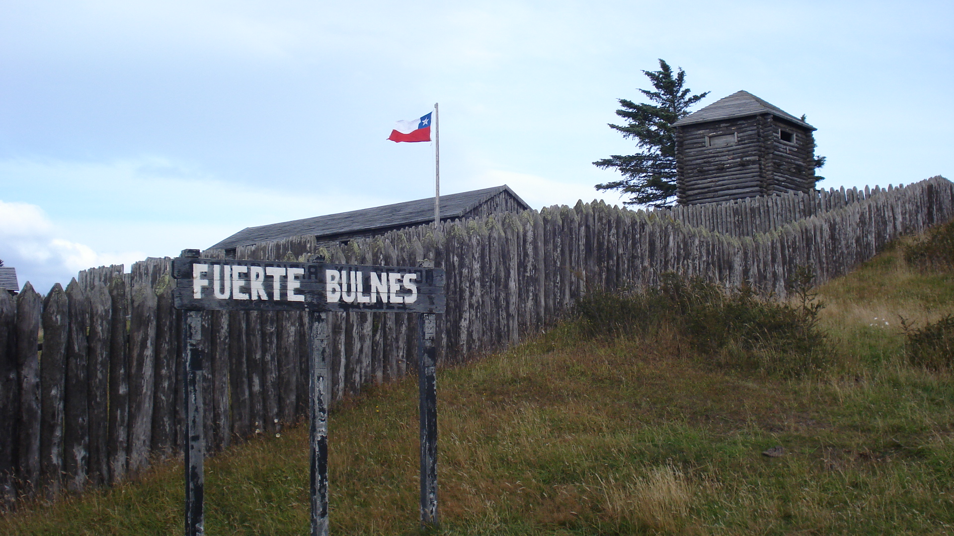
Picture of Fuerte Bulnes
The Republic of Chile founded Fuerte Bulnes in 1843, and later Punta Arenas in 1847, giving a strong impulse to steam navigation through the Strait of Magellan and probably averted the occupation of the strategically crucial strait by the European powers or the United States. As stated by Michael Morris in "The Strait of Magellan":[2]
- «An 1837 French expedition of Dumont D'Urville surveyed navigational conditions in the Strait of Magellan and recommended that a French colony be established at the strait to support future traffic along the route.»
Treaty of 1856[]
Welsh settlement in Chubut[]
In 1865 Welsh immigrants began to settle around the lower part of Chubut Valley. This colonization, supported by Argentina, meant that Argentina got a new exclave in Patagonia apart from Viedma-Carmen de Patagones, which had been founded in 1779. While the economic and geopolitical impact of this settlement was less than that of Chile's Punta Arenas, it soon became a starting point for further colonization toward the Andes.
Interests of Chile, Argentina and the great powers[]
Chile[]
Chilean trade and culture were oriented towards Europe and therefore the complete control of the strait was a core Chilean interest.[3] In contrast the rest of Patagonia was seen by influential Chilean politicians as a worthless desert.[4] This view was shared by Diego Barros Arana and was inspired by Charles Darwin's description of the area as a useless moorland.[2]
- The possession of the Straits of Magellan in all its length is of such great importance for Chile, that in that possession she sees linked not only her progress and development, but also her very existence as an independent nation.[3]
- - Adolfo Ibáñez
- The possession of the Straits of Magellan in all its length is of such great importance for Chile, that in that possession she sees linked not only her progress and development, but also her very existence as an independent nation.[3]
Argentina[]
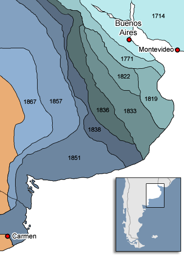

Map of the advance of the Argentina frontier until the establishment of zanja de Alsina
Mapuches and araucanized Indians had for a long time pillaged the Argentine southern frontier in search for cattle that was later taken to Chile through the Camino de los chilenos. The cattle was traded in Chile for weapons and alcoholic beverages. These tribes had strong connections with Chile and therefore gave Chile certain influence over the pampas.[4] Argentine authorities feared an eventual war with Chile over the region where the natives would side the Chileans, and that the war would be therefore fought in the vicinities of Buenos Aires.[5].
In the 1870s, Argentina built a more than 500-km long trench called Zanja de Alsina, which Argentina had undertaken during the Conquest of the Desert from 1876 to 1878 to defeat the araucanized Indians occupying northern Patagonia and which aspired to control the eastern third or, at a minimum, the eastern mouth of the strait.[5]
The great powers[]
Great Britain and the USA did not directly intervene in the distribution of land and maritime areas, but the U.S. ambassadors in Santiago de Chile and Buenos Aires, Thomas A. Osborn and Thomas O. Osborn, did serve as mediators. The concern of the great powers was free navigation through the strait. The U.S. administration declared immediately before the negotiations leading to the treaty that:[6]
- "The Government of the United States will not tolerate exclusive claims by any nation whatsoever to the Straits of Magellan, and will hold responsible any Government that undertakes, no matter on what pretext, to lay or impost or check on United States commerce through the Straits. ".
Prior to the U.S. statement, in 1873, via a diplomatic letter to major shipping nations, Chile had already promised freedom of navigation through and neutralization in the strait.[7]
The colonial powers, United Kingdom and France, viewed Patagonia and Tierra del Fuego as Terra nullius.[citation needed] Jules Verne described in "The Survivors of the 'Jonathan'"[8] his view of Patagonia:
- «The separated geographic location had as consequence that this part of the new world had not been incorporated to any civilized state up to the year 1881 even not by its nearest neighbour Chile and the Republic of Argentina. The Magalhães archipelago belonged to nobody… »
Regarding the position of the USA towards the region, on 28 December 1831, the US Navy Captain Silas Duncan with the USS Lexington destroyed the Port Louis, Falkland Islands settlement in response to Argentine activities. The captain declared the islands to be free of government.[9][10] In addition, the United Kingdom did not trust the Argentine rights to the region and reoccupied the Falklands in 1833.
Negotiation and agreement[]
In 1874 Chilean minister Guillermo Blest Gana and the Argentine Minister of Foreign Relations Carlos Tejedor agreed to put the question to arbitration. However, the new Argentine president Nicolás Avellaneda, boosted by internal popularity, cancelled the agreement in 1875. Attempts to clear up the dispute about Patagonia were unsuccessful until 1881, when Chile was fighting the War of the Pacific against both Bolivia and Peru. At that time Chile had defeated Bolivia's and Peru's regular armies and had large contingents in occupying Peru and fighting Andrés Avelino Cáceres' guerrillas. In order to avoid fighting Argentina as well, Chilean President Aníbal Pinto authorized his envoy, Diego Barros Arana, to hand over as much territory as was needed to avoid Argentina siding with Bolivia and Peru.[11]
Treaty[]
The treaty defined the border in only three articles.
It defined the border down to latitude 52°S as the line marked by the continental divide and the highest mountains of the Andes.
- Article 1:
- "The boundary between Chile and the Argentine Republic is from north to south, as far as the 52nd parallel of latitude, the Cordillera de los Andes. The boundary-line shall run in that extent over the highest summits of the said Cordilleras which divide the waters, and shall pass between the sources (of streams) flowing down to either side. …"
Articles 2 and 3 recognise the area around the Strait of Magellan (South of the 52°S) as Chilean as well as the islands south of Beagle Channel. Isla Grande de Tierra del Fuego was divided in two parts.
- Article 2: In the area of the Strait of Magellan, south of the parallel 52°S, the limit would go from Punta Dungenes north to Monte Dinero and then follow the small hills that separates the Atlantic watershed from the strait watershed until the latitude of Monte Aymond from where a straight line is drawn into the intersection of parallel 52°S and the meridian 70°W, and from there west along the 52° parallel until the last watershed divide point defined by article 1.
- Article 3:
- "In Tierra del Fuego a line shall be drawn, which starting from the point called Cape Espíritu Santo, in parallel 52°40', shall be prolonged to the south along the meridian 68°34' west of Greenwich until it touches Beagle Channel. Tierra del Fuego, divided in this manner, shall be Chilean on the western side and Argentine on the eastern. As for the islands, to the Argentine Republic shall belong Staten Island, the small islands next to it, and the other islands there may be on the Atlantic to the east of Tierra del Fuego and of the eastern coast of Patagonia; and to Chile shall belong all the islands to the south of Beagle Channel up to Cape Horn, and those there may be to the west of Tierra del Fuego."
Furthermore the treaty defines the status of the Strait of Magellan:
- Article 5
- "The Straits of Magellan shall be neutralized for ever, and free navigation assured to the flags of all nations. In order to assure this freedom and neutrality, no fortifications or military defences shall be constructed on the coasts that might be contrary to this purpose."
Article 6 states that older boundary treaties became obsolete and both countries agreed to submit any future disputes to the decision of a friendly third country.
Maritime border[]
The law of the sea at the time of the 1881 treaty was quite far different from the articles of the 1982 Law of the Sea, which meant that Chile and Argentina adhered to the accepted practice of a three nautical mile territorial sea. Therefore the treaty emphasized the delineation of land boundaries including islands but did not stipulate the offshore limits that have since been expanded to 200 nautical miles (370 km).
Further disputes[]
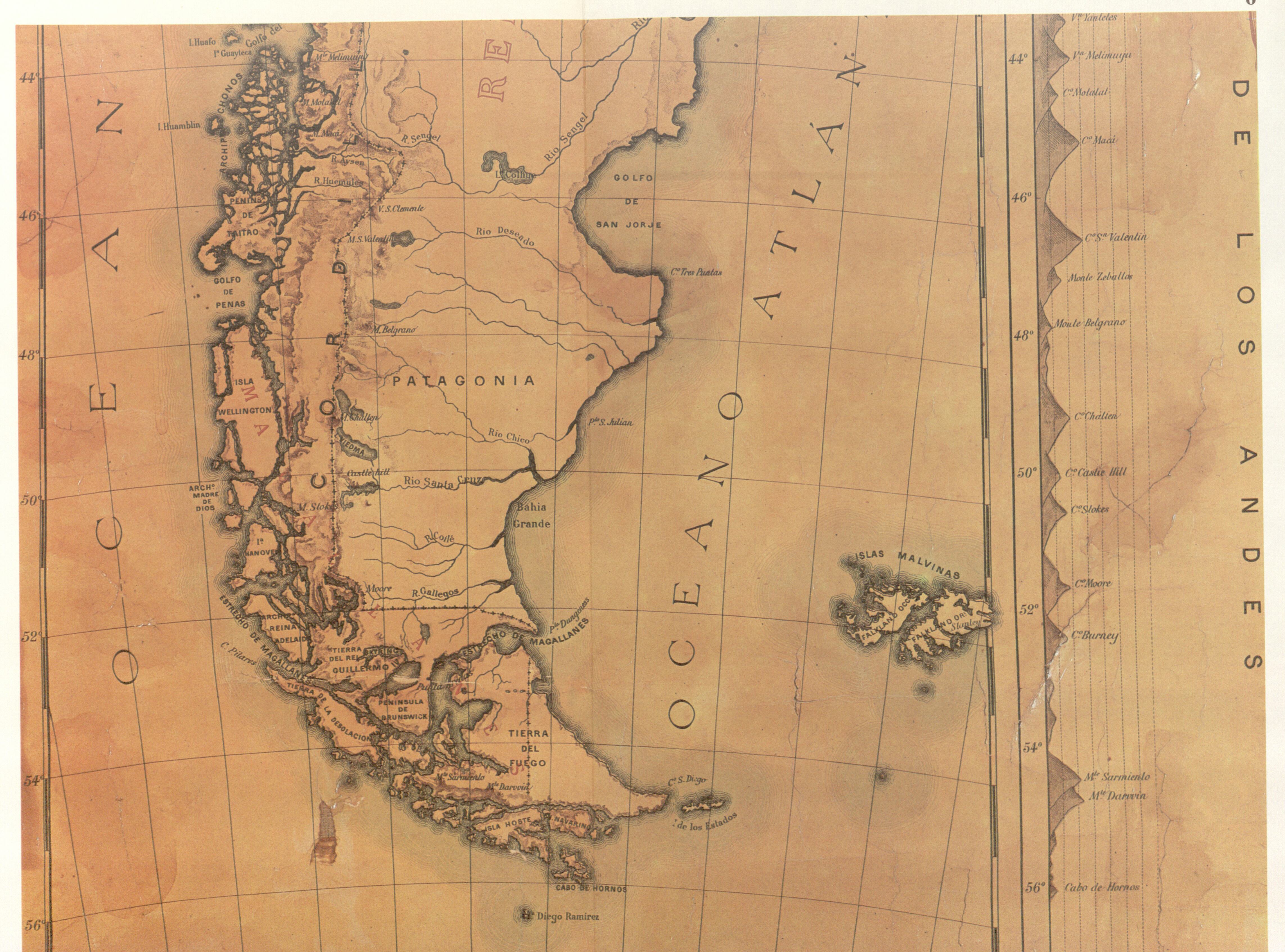
A map from 1884.
According to the Argentine view of the treaty, called the Magellan/Atlantic transfer, the general agreement was that Argentina was an Atlantic country while Chile was a Pacific one. Chile has never accepted that and the Chilean view was confirmed by the Court of Arbitration in the Beagle dispute (§31 [6]):
- "… .It is on this basis, as well as on the actual attribution of Patagonian territory to Argentina effected by Article II of the Treaty, that the Court reaches the conclusion that it was the antithesis Patagonia/Magellan, rather than Magellan/Atlantic, which constituted the fundamental element of the Treaty settlement.".
Some errors that would allow a Pacific coast for Argentina in Última Esperanza Sound and an Atlantic coast to Chile in San Sebastián Bay were later corrected, the border in Tierra del Fuego was moved from 68°34'00"W (as FitzRoy erroneously marked the "Cabo del Espiritu Santo) to 68°34'40"W (true longitude of the Cabo) giving 626 km2 to Argentina.[12] Different interpretations of the borderline north of latitude 52°S led to the Arbitration of the British King Edward VII in 1902 (See The Cordillera of the Andes Boundary Case).
Border disputes continued as Patagonia was still an unexplored area. The concept of the continental divide was easy to apply in northern regions but in Patagonia drainage basins crossed the Andes; this led to disputes over whether the highest peaks would be the frontier (favouring Argentina) or the drainage basins (favouring Chile). Argentina argued that previous documents referring to the boundary always mentioned the Snowy Cordillera as the frontier and not the continental divide. The Argentine explorer Francisco Perito Moreno suggested that many Patagonian lakes draining to the Pacific were in fact part of the Atlantic basin but had been moraine-dammed during the quaternary glaciations, changing their outlets to the west. In 1902, war was again avoided when British King Edward VII agreed to mediate between the two nations. He established the current border in the Patagonia region in part by dividing many disputed lakes into two equal parts; most of these lakes still have one name on each side of the frontier.
The dispute that arose in the northern Puna de Atacama was resolved with the Puna de Atacama Lawsuit of 1899, though its real cause was out of the scope of the 1881 boundary treaty and originated from transfers between Bolivia and Argentina of land occupied by Chile during the Pacific war.
")
")
")
")
Additional protocols[]
To prevent relations from being aggravated, or to complement the Boundary treaty, a succession of protocols and declarations had to be signed:
- 1889 Zeballos-Matta Declaration (occupation of disputed areas confers no rights)
- 1893 Protocol (to resolve some of the pending issues)
- 1902 Pactos de Mayo May pacts (no Argentine intervention in the Pacific items of Chile, naval arms control and a framework for arbitration)
Literature[]
"The Survivors of the 'Jonathan'", also known as "Magellania",[13] is a novel written by Jules Verne in 1897 and published posthumously in 1909, after it had been rewritten by Verne's son Michel under the title Les naufragés du "Jonathan".
The novel tells the story of a mysterious man named Kaw-djer who lives on Nueva island, whose motto is "Neither God nor master". He refused any contact with western civilization, relying on himself in order to survive and also provides assistance to the indigenous peoples of Magellania. However, the 1881 Boundary Treaty will destroy his paradise of individualist anarchism because it will end the state of terra nullius in the region.
Analysis[]

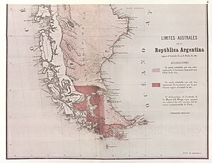
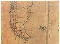
Partial reproduction of the first Argentine map showing the boundaries laid down in the Boundary Treaty of 23 July 1881.
Because each side was convinced of the legitimacy of its own claim, the pretensions of the other party were considered usurpatory, an ill-omened beginning that burdened the relations of both countries.[14]
The treaty did resolve an immediate concern of each side, but subsequently it became evident that in the far south, about 42°S to 52°S, article 1 of the treaty posed problems of interpretation and application.
Some Argentine political publicists argue that articles 2 and 3 of the treaty were ambiguous,[15] but they have to admit the truth that the later Argentine interpretations were refused by the international tribunal, that Argentine maps of the first decade also applied the Chilean interpretation and the two papal proposals as well as the treaty of 1984 maintained the Chilean interpretation of the treaty, at least in so far as the land border line.
There could be other reasons for the Argentine difficulties over the interpretation. Michael Morris observes about the Argentine policy:[16]
- «Rearguard Argentine efforts has been made to gain recognition for some kind of shared management regime for the Strait [of Magellan], in order to mitigate what was perceived as the striking diplomatic defeat for Argentina in the 1881 treaty granting Chile control over the strait.»
The Southern Patagonian Ice Field is the last still pending issue in order to apply the 1881 Boundary Treaty.
See also[]
- Tierra del Fuego gold rush
- Beagle Channel cartography since 1881
- Beagle conflict
- War of the Pacific
References[]
- ↑ See Libro de Defensa de Chile CONTINUIDAD: HISTORIA Y GEOGRAFÍA
- ↑ Michael Morris in "The Strait of Magellan", Martinus Nijhoff Publisher, 1989, ISBN 0-7923-0181-1, pages 22 and ff.
- ↑ See Michael Morris, "The Strait of Magellan", Martinus Nijhoff Publisher, 1989, ISBN 0-7923-0181-1, pages 62 and 63
- ↑ According to Aníbal Pinto Garmendia, President of Chile at the time:
- «ningún hombre sensato de Chile pretendía la Patagonia» (Translation: "no reasonable Chilean man wanted Patagonia"),
- ↑ See Michael A. Morris, "The Strait of Magellan", Martinus Nijhoff Publishers, ISBN 0-7923-0181-1, page 63
- ↑ See Erik Brüel, International Straits, Vol. II, Sweet and Maxwell, Ltd., London, England, 1947, p225. Cited in Michael A. Morris, "The Strait of Magellan", Martinus Nijhoff Publishers, ISBN 0-7923-0181-1, page 65
- ↑ See Michael A. Morris, "The Strait of Magellan",Martinus Nijhoff Publishers, 1988, ISBN 0-7923-0181-1, page 68 and 104
- ↑ See Jules Verne, "Die Schiffbrüchigen der Jonathan", page 17, Edition 1984, Pawlak Taschenbuch Verlag, Berlin, ISBN 3-8224-1096-9
- ↑ Report by Silas Duncan,Commander U.S.S. Lexington, sent to Navy Secretary Levi Woodbury, on 4 April 1832
- ↑ Commander Silas Duncan and the Falkland Island Affair, Accessed 2007-10-02
- ↑ See Michael A. Morris, "The Strait of Magellan", Martinus Nijhoff Publishers, ISBN 0-7923-0181-1, page 62:
- "From a Chilean perspective, possible Argentine entry into the War of the Pacific as a belligerent or even as an unfriendly power was a real threat so that Chile was concerned about assuring the neutrality of Argentina and other South American States."
- ↑ Juan Agustin Rodriguez S., "Chile en el Canal Beagle y Mares Australe", Grafica Progresion, 1985
- ↑ Les Voyages Extraordinaires. In French, Magellania, En Magellanie, or Les Naufragés du "Jonathan".
- ↑ See Michael Morris, "The Strait of Magellan", Martinus Nijhoff Publisher, 1989, ISBN 0-7923-0181-1, page 59.
- ↑ See El carácter ambiguo del texto del tratado de 1881
- ↑ See "The Strait of Magellan", Michael Morris, Martinus Nijhoff Publishers, ISBN 0-7923-0181-1, pages 120 and 121
Bibliography[]
- Michael A. Morris, "The Strait of Magellan", Martinus Nijhoff Publishers, ISBN 0-7923-0181-1, 237 pages.
External links[]
- British Arbitration 1977: Beagle channel conflict: Report and decision of the Court of Arbitration, among other documents, it contents also the English and the Spanish version of the Boundary Treaty 1881.
- British Arbitration 1902: The Cordillera of the Andes Boundary Case Argentina, Chile
- Historia de las Relaciones Exteriores Argentinas Chapter 32 to 34, in Spanish Language
- Karin Oellers-Frahm: Der Schiedsspruch in der Beagle-Kanal-Streitigkeit, Berichte und Urkunden: Max-Planck-Institut für ausländisches öffentliches Recht und Völkerrecht, in German language.
The original article can be found at Boundary Treaty of 1881 between Chile and Argentina and the edit history here.