| Camp Abbot | |
|---|---|
| Deschutes County, near Bend, Oregon | |
 World War II combat engineer training center | |
| Coordinates | 43°52′22″N 121°26′42″W / 43.8727°N 121.4450°WCoordinates: 43°52′22″N 121°26′42″W / 43.8727°N 121.4450°W |
| Type | Military cantonments |
| Site information | |
| Owner |
United States Forest Service - public; Sunriver Resort Limited Partnership - private |
| Site history | |
| Built | 1942 |
| Built by | United States Army Corps of Engineers |
| In use | March 1943 - June 1944 |
| Demolished | ca. 1945 |
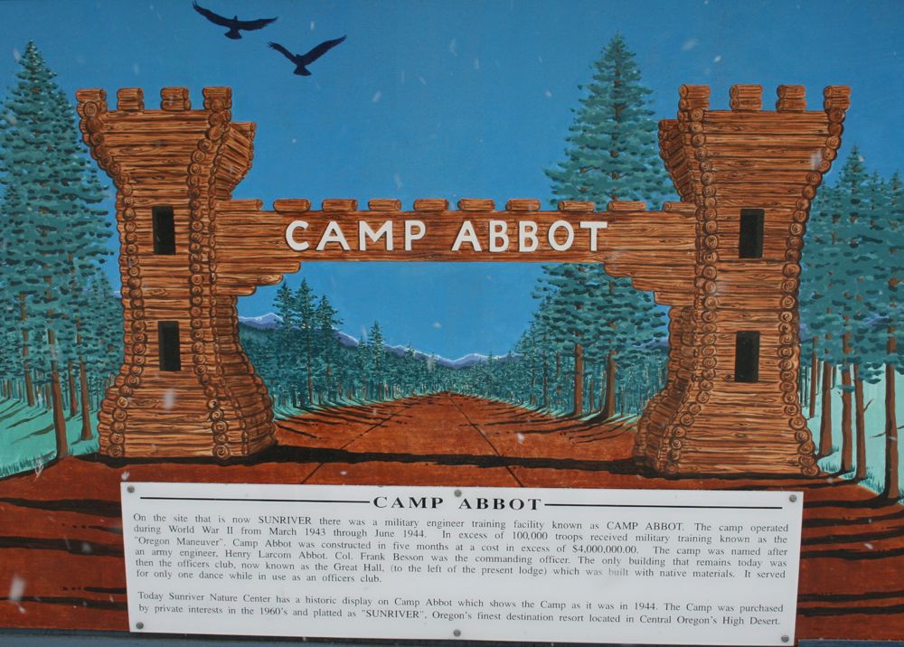
Camp Abbot was a United States Army training center located south of Bend, Oregon, United States. The center was used to train combat engineers during World War II. A large part of site has now been developed as Sunriver Resort. The rest has been incorporated into the Deschutes National Forest. The only remaining structure from Camp Abbot is the officers mess hall. Today, it is part of Sunriver Resort. It is known as the Great Hall, and is used for large conferences and special events.
Site history[]
In 1855, Secretary of War Jefferson Davis dispatched an Army Corps of Topographical Engineers survey party to look for a railroad route from the Sacramento Valley in California to the Columbia River in the Oregon Territory. This required the party to survey the Deschutes River area in central Oregon. The survey party was led by two Lieutenants, Robert Stockton Williamson and Henry Larcom Abbot.[1][2]
The Williamson-Abbot survey party included a geologist-botanist, a physician-naturalist, several assistant engineers, a computation specialist, a pack master, and eighteen mule packers. At Fort Reading, a military escort of eighty infantrymen and twenty cavalry troopers joined the party. The escort was commanded by Lieutenant H. G. Gibson with Lieutenants George Crook and Philip H. Sheridan leading elements of the detachment.[1][2]
While in central Oregon, illness forced Lieutenant Williamson to return to California. This left Lieutenant Abbot in charge of the expedition. On 4 September 1855, Abbot and a detachment of the survey party camped at a site along the Deschutes River that would become Camp Abbot. Abbot completed the survey of central Oregon, crossed the Cascade Mountains into the Willamette Valley, and then returned to Fort Reading, arriving in mid-November 1855. In 1857, the Army published Abbot's thorough 499 page report under the title Report of Lieut. Henry L. Abbot Upon Explorations for a Railroad Route from Sacramento Valley to the Columbia River.[1][2][3]
World War II[]
During World War II, the Army needed to rapidly expand its combat engineer training. On 4 December 1942, the War Department established a 5,500 acres (22 km2) combat engineer replacement and training center along the Deschutes River south of Bend, Oregon. It was named in honor of Brigadier General Henry Larcom Abbot, who had led a survey party through the area in 1855. The first trainees arrived at Camp Abbot in March 1943, even before the camp was formally dedicated on 2 September 1943.[3][4][5] At that time, it was one of only three combat engineer training centers in the United States; the other two being Fort Belvoir (Virginia) and Fort Leonard Wood (Missouri).[6]
Approximately 10,000 soldiers were trained during each 17 week cycle. The training was conducted in three phases. The first part of the course focused on rifle marksmanship and other basic combat skills. The first phase also included special training on hand grenades, anti-tank mines, and other combat engineering tasks. The second phase was demolition training. During that phase, trainees learned how to build and destroy bridges and other structures. The final phase was three weeks of field maneuvers carried out under combat conditions. Over 90,000 combat engineers were trained at Camp Abbot before the center was closed in June 1944. Most of the camp structures were demolished shortly after the training center closed.[4][7]
Post-war development[]
In the years following World War II, a portion of the Camp Abbot property was returned to the United States Forest Service. However, approximately 3,800 acres (15 km2) were sold as private land. That property changed hands a number of times, until it was purchased by John Grey in 1965. Grey began development of Sunriver Resort, selling the first residential lots in 1968. Today, Sunriver is a luxury resort with a 250 room lodge, three golf courses, six restaurants, and an executive airport. There are approximately 4,000 homes on the adjacent Sunriver property along with a small commercial district that supports the shopping needs of the community.[8][9][10]
Original structures[]

The officers' mess is now the Great Hall at Sunriver Resort

The General Patch Bridge in 2008
Today, only one original Camp Abbot building remains. The officers' mess hall was built in 1944 by the Army Corps of Engineers under the direction of Captain John V. Banks. It still exists at its original location; however, it is now part of Sunriver Resort, known as the Great Hall and is used for large conferences and special events such as banquets and weddings.[9]
The historic Great Hall is an impressive log structure measuring 50 by 96 feet (15 by 29 m). It was constructed using native stone and logs cut near the building site. The Great Hall has a high ceiling with exposed beams, a large stone fireplace, and a balcony overlooking the main floor. There are also small side rooms including an intimate fireside room and a number of conference rooms. In 1993, Sunriver Resort completed a major renovation of the Great Hall. As a result, the historic Great Hall is a modern facility with unique architectural character.[8][9]
The only other Camp Abbot structure to survive for an extended period was the General Patch Bridge which was constructed in 1944 by Army engineers during the Oregon Maneuver. The Oregon Maneuver was the largest military field exercise ever conducted in the Pacific Northwest. It involved over 100,000 army troops, many of them combat engineers based at Camp Abbot. The maneuver extended across six eastern Oregon counties. Camp Abbot was used as the exercise headquarters because of its central location and military infrastructure.[11][12][13]
The General Patch Bridge was located on Deschutes National Forest land within the boundaries of old Camp Abbott. The bridge was named for General Alexander M. Patch, who led the Oregon Maneuver.[11] The Forest Service demolished the bridge in 2008 because the structure was unsafe.[14]
References[]
- ↑ 1.0 1.1 1.2 Abbot, Charles Greeley, Biographical Memoir of Henry Larcom Abbot, National Academy of Sciences, Washington, D.C., 1929.
- ↑ 2.0 2.1 2.2 Jette, Melinda, "Mount Jefferson and Black Butte", Oregon History Project, Oregon Historical Society, 2003.
- ↑ 3.0 3.1 McArthur, Lewis A. and Lewis L. McArthur, Oregon Geographic Names (Seventh Edition), Oregon Historical Society Press, Portland, Oregon, 2003, p. 140.
- ↑ 4.0 4.1 "Here Come the Servicemen: Oregon Military Facilities", Life on the Home Front Oregon Responds to World War II, online exhibit, Oregon State Archives, Oregon Secretary of State, Salem, Oregon, 2008.
- ↑ "History", Sunriver Visitor Guide, Sunriver Publishing, Bend, Oregon, 10 May 2009.
- ↑ Person, Gus (Installation historian), "Old replacements training center transformed Soldiers to engineers", Belvoir Eagle, Installation Public Affairs Office (in cooperation with Media General Operations Inc., Woodbridge, Virginia), Fort Belvoir, Virginia, 14 April 2008.
- ↑ "Sunriver History", Deschutes County Government, www.co.deschutes.or.us, Bend, Oregon, 10 May 2009.
- ↑ 8.0 8.1 Anderson, John Gottberg, "A Sunriver ‘stay-cation’ - Making the road close to home a little more traveled", The Bulletin, Bend, Oregon, 1 February 2009.
- ↑ 9.0 9.1 9.2 "Camp Abbot Officers Club”, Deschutes County Landmarks, Deschutes County Government, Bend, Oregon, 17 January 2001.
- ↑ "The Resort", Sunriver Resort, www.sunriver-resort.com, Sunriver, Oregon, 10 May 2009.
- ↑ 11.0 11.1 McArthur, Lewis A. and Lewis L. McArthur, Oregon Geographic Names (Seventh Edition), Oregon Historical Society Press, Portland, Oregon, 2003, p. 398.
- ↑ "General Patch Bridge Removal", Environmental Assessment, Deschutes National Forest, United States Forest Service, United States Department of Agriculture, Bend, Oregon, June 2008, p. 3.
- ↑ “Senate Bill 449”, 75th Oregon Legislative Assembly, Salem, Oregon, 2009.
- ↑ "Patch Bridge Removal", contract solicitation, Deschutes National Forest, United States Forest Service, United States Department of Agriculture, Hermiston, Oregon, 29 July 2008.
External links[]
The original article can be found at Camp Abbot and the edit history here.