| Denver Air Defense Sector | |
| military region | |
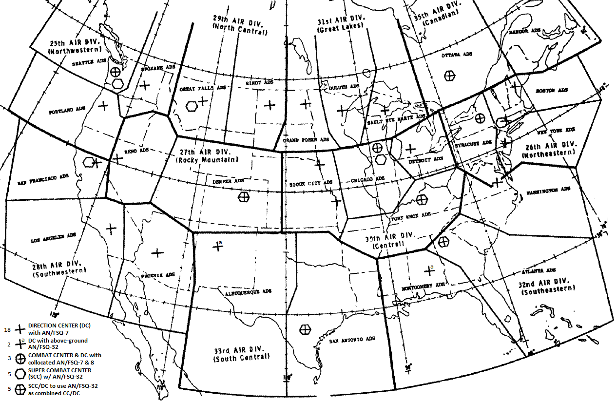 The 5-sided Denver ADS had corners in Idaho, South Dakota, Oklahoma, Arizona, and Nevada. The Super Combat Center near the 40th parallel northfor both sectors of the Rocky Mountain Division was also to be used as a Direction Center (SCC/DC).
| |
| Country | United States |
|---|---|
| Part of | Austere SAGE area |
| Military installations |
SCC/DC: [never built] ADC airbases: tbd AFB Radar stations: Lowry AFB, … |
| Location | planned SCC/DC site 39°21.7′N 104°38.9′W / 39.36167°N 104.64833°W[2] (approx.) |
The Denver Air Defense Sector was a NORAD geographic area designated during the Cold War in the Zone of Interior (ZI) for both air defense and air traffic control, as well as the name of the planned military unit for conducting radar surveillance and fighter-interceptor operations in the sector area. The Denver ADS spanned the entire state of Colorado, nearly all of Utah, most of Wyoming and western Nebraska, and small parts of Kansas, Oklahoma, New Mexico, Arizona, and Nevada. Targets in the sector included the military/industrial facilities and urban civilian populations of the metropolitan areas at Salt Lake City, Cheyenne, Denver, and Colorado Springs—the Colorado underground ICBM construction began in tbd. (Omaha and Wichita military/industrial complexes were in the Sioux City sector).
Along with the adjacent Reno Air Defense Sector, the Denver ADS was designated to be in the 27th Air Division ("Rocky Mountain" division) between August 1 and December 31, 1958, under NORAD's July 25, 1958, SAGE Geographic Reorganization Plan for the orderly transition and phasing from the manual to the" SAGE Defense System of radar stations, interceptor bases, and a new computer and communications network creating a Semi-Automatic Ground Environment.
After 10 Super Combat Center (SCC) in underground bunkers were designated by the "USAF ADC Plan" approved by NORAD on December 20, 1958,[3] additional Air Defense Command planning designated an SCC was to be constructed[where?] for command and control. The Denver SCC/DC was planned to become operational by May 1964.[4]
Geography[]
The area of the Denver Air Defense Sector was an irregular pentagon from the Great Basin's northerneastern corner through the Central Rocky Mountains to the East border (100.65 meridian West) in the Great Plains.[2] Formed primarily from the southern portion of the pre-SAGE 29th Air Division, smaller additional areas of the 25th & 28th Air Divisions were included to the West, the 25th & 34th ADs to the South, and to the East the 31st, 20th, & 33rd ADs. After the USAF had proposed Lowry AFB in 1958 for a new NORAD facility (as it woould be temporary USAF Academy facilities were to be vacated),[5]:111 the bunker for both the sector headquarters and the SCC/DC at the Denver Metropolitan Area was published in the January–June 1959 NORAD Historical Summary (declassified by NORAD/J3 in 1998).[3]
Austere SAGE area[]
In June 1959, in conjunction with SecDef approval for an "Improved SAGE environment" near coasts of the US and its Canadian border—plus 1 sector in Canada, an "Austere SAGE environment" was also planned.[6]:69 A military region in the "south-central and central area" of the US in 6 sectors defined in the July 1, 1959, SAGE Implementation Schedule:
- "Denver Air Defense Sector, Sioux City Air Defense Sector, Albuquerque Air Defense Sector, San Antonio Air Defense Sector, Phoenix Air Defense Sector (east of 112°), and Fort Knox Air Defense Sector (west of 86°30')"
| Point & state(s) | Adjacent sector(s) | Location |
|---|---|---|
| corner:NW ID
|
Reno/Great Falls | |
| state line ID/WY
|
Great Falls | |
WY
|
Great Falls & Minot | |
| state line WY/SD
|
Minot | |
SD
|
Minot/Grand Forks | |
| corner: NE SD
|
Grand Forks/Sioux City | 43.5°N 100.65°W / 43.5°N 100.65°W |
| state line SD/NE
|
Sioux City | 43.0°N 100.65°W / 43°N 100.65°W |
| state line NE/KS
|
Sioux City | 40.0°N 100.65°W / 40°N 100.65°W |
| state line KS/OK
|
Sioux City | 36.5°N 100.65°W / 36.5°N 100.65°W |
| corner: SE OK*
|
Sioux City/Albuquerque | |
| state line OK*/NM
|
Albuquerque | |
| state line NM/AZ
|
Albuquerque | |
| corner: SSW AZ
|
Albuquerque/Phoenix | |
| state line AZ/UT
|
Phoenix | |
| state line UT/NV
|
Phoenix | |
| corner: W NV
|
Phoenix/Reno | |
| state line NV/UT
|
Reno | |
| state line UT/ID
|
Reno | |
| *The 1959 map does not show a distinct line between the southern Oklahoma panhandle state line and the Denver ADS. | ||
was constituted by NORAD on October 7, 1959, as the new "austere SAGE area" to have limited gap filler coverage and no advanced radars).[6]:70
Previously planned bunkers for the SCC/DCs at Denver (27th) and San Antonio (33rd) plus an above-ground AN/FSQ-32 at Albuquerque[2] were reconsidered for the austere SAGE area to instead have "three Super Combat Centers in soft configuration".[6] NORAD, USAF, and ADC agreed on a "new radar program" with the austere conditions, and on December 9, 1959, HQ USAF deferred construction of the underground "Denver" bunker for the SCC "because of budget considerations for FY 1961" (other SCCs, including the Ft Knox SCC/DC east of 86°30', were approved despite the hold order on SCC equipment).[6] Plans for the Rocky Mountain Division were discontinued by January 15, 1960,[6]:4,33 and coordination of interceptors for the general area was instead controlled by the 29th and 34th Air Divisions. The Denver SCC/DC was entirely cancelled with all Super Combat Centers on March 18, 1960, after a OSD evaulation[6] and c. 1961, the military region with the NORAD headquarters at Ent Air Force Base in Colorado Springs was the only CONUS area not an Air Defense Sector.
References[]
- ↑ Facility Orientation Guide: Denver ARTCC (Report).
- ↑ 2.0 2.1 2.2 2.3 1959 SAGE-FAA sector map (Map). (p. 22 of January–June 1959 NORAD Historical Summary.)
- ↑ 3.0 3.1 Preface by Buss, L. H. (Director) (1 November 1959). North American Air Defense Command and Continental Air Defense Command Historical Summary: January–June 1959 (Report). Directorate of Command History: Office of Information Services. "Approval of the USAF ADC plan to employ the new solid state computer, AN/FSQ-7A, by NORAD on 20 December 1958 and USAF on 5 February 1959 necessitated great changes in the transition to SAGE.· The ADC plan provided that the solid state computer would be employed in nine division combat centers in the U. S. and in one in Canada. … Five of the division SCC's were to perform a dual function, i e., in addition to operating as an SCC, they were to operate as a direction center (the 30th, 32d, 33d, 27th, and 35th)." (p. 20)
- ↑ Preface by Buss, L. H. (Director) (14 April 1959). North American Air Defense Command and Continental Air Defense Command Historical Summary: July–December 1958 (Report). Directorate of Command History: Office of Information Services. "On 7 October 1959, NORAD provided guidance on [changed deployments] to ADC as follows. 1. The following austere SAGE area is constituted using the sectors as defined on page 7, SAGE Implementation Schedule, 1 July 1959: Denver Air Defense Sector, Sioux City Air Defense Sector, Albuquerque Air Defense Sector, San Antonio Air Defense Sector, Phoenix Air Defense Sector (east of 1120 ), and Fort Knox Air Defense Sector (west of 86°30')."
- ↑ Preface by Buss, L. H. (Director) (1 October 1958). North American Air Defense Command Historical Summary: January–June 1958 (Report). Directorate of Command History: Office of Information Services. "In the meantime, USAF concluded that the best location for NORAD was Lowry AFB, Denver, Colorado" (p. 111)
- ↑ 6.0 6.1 6.2 6.3 6.4 6.5 Preface by Buss, L. H. (Director) (1 May 1960). North American Air Defense Command and Continental Air Defense Command Historical Summary: July–December 1959 (Report). Directorate of Command History: Office of Information Services. http://www.northcom.mil/FOIA/docs/1959%20NORAD%20CONAD%20History%20Jul-Dec.pdf.
The original article can be found at Denver Air Defense Sector and the edit history here.