| Wade's Causeway | |
|---|---|
|
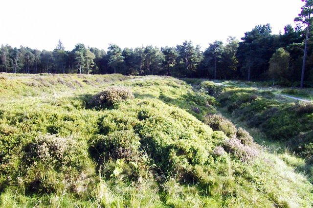
[[File:{{{image_name}}}|240x240px|Wade's Causeway, c. 2005]] Wade's Causeway, c. 2005 | |
| Type | linear monument, possibly road or dike |
| Location | Egton Parish, North Yorkshire, England |
| Coordinates | 54°22′14″N 0°45′33″W / 54.370575°N 0.759134°W |
| Built | [uncertain] |
Wade's Causeway is the name most commonly given to a sinuous, linear monument up to 6000 years old that lies within the North York Moors national park area in North Yorkshire, England. The name may refer to either scheduled ancient monument number 1004876—an extant length of stone course of just over one mile in length on Wheeldale Moor, and that is known locally as the Skivick—or to a postulated greater original extension of this structure to the north and south for up to 25 miles. The extant, visible course on Wheeldale Moor consists of a modest embankment of soil, peat, gravel and loose pebble 0.7 metres (2–3 feet) in height and 4–7 metres (16–26 feet) in width. The gently cambered embankment is capped with unmortared and loosely abutted flagstones. Its original form is somewhat uncertain since it has been greatly weathered by nature and subjected to extensive damage by man.
The structure has been the subject of oral folklore in the surrounding area for several hundred years and possibly more than a millennium. Its construction was commonly attributed in folkloric tales to a giant known as Wade, thought to have been a mythological figure of Germanic or Norse origins. It was not until the 1720s that the causeway was mentioned in a published text, after which it became known outside of the local area. Within a few years it became of interest to a number of antiquarians who visited the site and exchanged commentary on the structure's probable historicity. These early historians interpreted the monument as a causeway across marshy ground, most commonly attributing its construction to the Roman military in the first or fourth centuries AD. This explanation went largely unchallenged throughout the eighteenth and nineteenth centuries.
The extant length of the causeway on Wheeldale Moor was cleared of vegetation and excavated in the early twentieth century by a local gamekeeper with an interest in archaeology. Historian Ivan Margary, an authority on Roman roads, agreed with identification of the causeway as a Roman road, and assigned it the catalogue number 81b in the first edition of his Roman Roads In Britain (1957). The causeway was then the subject of further excavation and extensive study over the course of a decade by archaeologist Raymond Hayes in the 1950s and 1960s, partially funded by the Council for British Archaeology. The results of his investigation, which concluded that the structure was a Roman road, were published in 1964 by the Scarborough Archaeological and History Society.
In the late twentieth and early twenty-first centuries, the identification of the structure as a Roman road has been questioned by academics, and a variety of alternative interpretations suggested for the causeway's purpose and date of construction. The site's co-managers, English Heritage, in 2012 proposed several avenues of research that might be used to settle some of the questions that have arisen regarding the structure's origins and usage.
Description[]
Construction[]


Cross-sectional diagram of Wade's Causeway, based on description given in Young (1817) and Hayes and Rutter (1964)
The extant section of the structure that remains visible on Wheeldale Moor appears to show the remains of a continuous surface metalled with closely fitted slabs of sandstone[1] with flat upper surfaces.[2] The slabs vary in size considerably, with an average surface area of 45 cm (18 in) square, but some examples reaching 1.5 m (5 ft) in breadth.[1] An oddity of the stone flags is the existence of a central raised ridge along one section of the causeway, reported in two independent excavations of the site, and of unknown purpose.[2] The stone flags are reported as being seated on a cambered base stratum of mixed gravel, clay[3] and either rubble,[4] peat[2] or soil,[1] the whole forming a raised embankment. The natural underlying geology consists of patches of sand and gravel on top of oolitic limestone.[5] The embankment is variously reported as having widths from 3.6[6] to 7[7] metres (12–23 feet) at its raised surface. The total width is, in some sections, increased by another 1 metre of cut ditch to either side of the structure, which may or may not be associated with its original construction, making for an approximately uniform total width of 5–8 metres (16–26 feet).[3] The height of the causeway above surrounding soil level is approximately 40 cm (15 in).[7]
Hayes and Rutter state that the primary purpose of such an embankment would have been to provide good drainage for a road surface.[1] The area through which the Wheeldale structure runs is, as of the twenty-first century[update], an area of predominantly uncultivated heather moorland[8] but Wheeldale Moor is in places poorly drained, making it susceptible to flooding in both the ancient[4] and modern[9] eras. Archaeologist David E Johnston states that the structure is crossed by numerous drainage culverts with small becks trickling through them, because the underlying ground is often boggy.[10] This could suggest a reason for the structure's embankment, and its early attribution as a causeway—a route across wetland,[11] normally supported on earth or stone in the form of a raised embankment. However, nineteenth-century antiquarian Thomas Codrington argued that Roman roads in Britain—if such the structure is—were generally built on embankments regardless of the underlying ground's drainage.[12] He states that the common appellation of "causeway" in the names of Roman roads may, therefore, relate simply to their habitually embanked structures rather than indicate that the ground on which they were constructed was necessarily ill-drained or susceptible to flooding.[13]
Johnston and landscape historian Richard Muir both agree that an original gravel surface dressing that sat on top of the extant stone was once present on the Wheeldale structure. However, whereas Johnston believes that the gravel was washed away through weathering,[10] Muir states that human agents were primarily responsible for its removal.[14] Both agree that the stonework remaining does not represent the original road surface. Statements by the eighteenth-century antiquary Francis Drake and nineteenth-century topographer Samuel Lewis that the writers found the structure to be "paved with a flint pebble" may lend credibility to this theory,[5] although Hayes and Rutter cast doubt on the accuracy of Drake's reports.[6] Codrington states that in 1817 the causeway consisted of a "strong pavement of stones...[with] above these another stratum of gravel...",[15] Hayes and Rutter state that "traces of a surface layer of gravel and small stones" remained visible in the 1960s,[16] and professor of structural engineering John Knapton states that there remained some evidence of smaller surface-dressing pebbles as late as 1996.[17]
The structure has, in some sections only, been reported by Codrington and archaeologist Frank Elgee to have had ditches on either side that run parallel to its course,[18] but Hayes is both doubtful of their existence, and also doubtful of whether these represent the structure's original construction.[19]
The causeway's course is broadly linear on the macro scale along its visible section on Wheeldale Moor,[20] consisting on closer detail of several short, straight sections that pivot occasionally onto new alignments in a way not clearly demanded by the landscape or surveying concerns.[21]
Extant course[]


Map showing sections of Wade's Causeway reported as verified extant, by various authorities 1736–2013
The excavated portion of the Wheeldale structure—the only section of a postulated greater extent that remains clearly visible to the naked eye—consists of a 1.2 mile (1.9 km)[22] section of the structure on the eastern edge of Wheeldale Moor, facing Howl Moor. It runs in an approximately north-north-easterly direction between grid reference SE 80344 97382 and grid reference SE 81077 98697, and is approximately 185–200 metres above sea level.[22] The presence of large quantities of stone on a raised agger, and the absence of much vegetation on its surface, make the presence of the structure indisputable along this section.[7] In 1855, several overgrown fragments of the structure were also reported visible at several points in the vicinity: near Morley Cross; east of Keys Beck; near Hazle houses; at July Park; and at Castle Hill.[23]
Possible extended course[]
The structure is believed by several writers to extend far beyond its visible portion,[8] however no significant sections of its additional conjectured course remain visible to the naked eye or have been excavated or extensively surveyed, and there is little agreement on an exact course that an extension of the structure may have taken. The original length of the structure in its entirety is therefore unknown, but may have been up to 25 miles.[9]
To the north[]
Early records of the Causeway's course to the north—when its remains were apparently more readily visible than today—differ considerably from one another:[24] The early geologist and natural historian Reverend George Young, who wrote in relation to the causeway in his History of Whitby, makes no clear mention of the route of the structure north of Wheeldale Moor; it is unmarked on the 1854 Ordnance Survey map of the area; and eighteenth-century historian Thomas Hinderwell's mention of it passing near Hunt House suggests a greatly differing route to that marked on 2012 Ordnance Survey mapping. At least one source states that a "conjectural" continuation of the structure to the north is visible in aerial photography.[25] Hayes reports that in his survey in the 1950s, he found "trace of the embankment" in one short section and "a patch of the metalling" in four additional sections along a route past Hazle Head and Julian Park.[26]
Beyond Julian Park, it has been conjectured that the structure originally continued to the Roman garrison fort at Lease Rigg, south west of Sleights, based on reports from antiquarians in the eighteenth and nineteenth centuries that fragments of the structure were visible at numerous points along this course. Hayes and Rutter appear confident of the structure's extent as far as Lease Rigg, but admit that its extent is conjectural from well short of that point, from Dowson Garth Quarry northwards.[27]
Numerous authors have conjectured that the structure was a road that continued past Lease Rigg all the way to Roman coastal fortifications or signal stations somewhere near Whitby,[10] but this is debated.[28] Drake reports in 1736 that an associate had followed the course of the structure from Wheeldale Moor to the coast at Dunsley Bay,[29] but Codrington is dismissive of his account,[15] and whether the author meant to imply that a visible structure had been followed, or simply whether the associate had followed a proposed route without actually encountering the structure, is somewhat unclear. In either case, the author did not actually verify sight of the extant structure along this course himself. Oulton reports the same endpoint for the road in his 1805 Traveller's Guide, but it is unclear if he is simply echoing Drake or had visited the site himself.[30] Muir states that any termini beyond Lease Rigg are "unproven",[14] and Elgee states that the causeway's northern course "is obscure and its termination unknown".[31] Hayes and Rutter in 1964 found no evidence for a continuation of the structure any further north than Lease Rigg.[32] Other authorities argue for possible courses extending northwards to Goldsborough,[11] Guisborough,[33] or Sandsend Bay.[34]
To the south[]

Surviving ditch and embankment in Cawthorn Roman Camp
It has also been suggested that the structure originally extended southwards from Wheeldale Moor to link up to the Roman Cawthorne Camp (sometimes spelled 'Cawthorn'). In the twentieth century English Heritage identified two sections of ground on Flamborough Rigg and Pickering Moor as extensions of the Wheeldale structure.[12] Hayes states that the Flamborough Rigg section remained "clearly visible" as late as 1961,[35] and that additional sections near Keys Beck were visible in aerial photography from 1946.[36] The accounts of Hinderwell, Young, and Hayes & Rutter, as well as the 1854 and 2012 Ordnance Survey maps, also appear to correlate strongly as to the stated course of the structure along this section.
There is further conjecture that the original structure's course may have stretched beyond Cawthorne Camp to the Roman settlement of Derventio Brigantum (possibly either Stamford Bridge[37] or modern-day Amotherby near Malton).[13] However, any postulated extension of the structure further south than Cawthorn is contested.[28] Hinderwell reports in 1811 that the late Robert King had found evidence of a continuation of the causeway structure between "Newsom-bridge" and Broughton[38] (a former township located near Appleton-le-Street).[39] Hayes and Rutter failed to find any trace of the postulated extent of the causeway south of Cawthorn along a route via Amotherby, Barugh or Newsham in their survey in the 1950s,[14] and note that its course could not be determined as early as 1726.[24]
Beyond Malton, there is a postulated stretch of Roman road leading towards York, which it it possible may be an extension of the causeway. Evidence for it is very slim indeed: it is mentioned by Drake in 1736, but Codrington could find no trace of it in 1903,[40] and writes that there is "some uncertainty as to the connexion".[41] Archaeologists Philip Corder and John Kirk reported a possible section of Roman road at Brandrith Farm (SE 698692) in 1928,[42] but it is unknown whether this relates either to the same structure as Drake observed, or has any association with the Wheeldale structure.
Legendary interpretations[]
Historian Hector Munro Chadwick states that historical explanations for ancient structures would have been known to at least educated clergymen from as early as the seventh century, but that the structures would generally be named by less educated persons, often after mythological characters.[43] Oral folklore in the North York Moors area from the Early Middle Ages has not generally survived into the modern era, but social historian Adam Fox states that the attribution of the causeway to Wade existed in oral folklore dating from at least as early as the Renaissance era.[44] The folklore held that the causeway was built by a giant called Wade[2] for his wife to take her cow[15] to either market or pasture.[16] In 1890, historian Thomas Bulmer records that:
[Wade] is represented as having been of gigantic stature... His wife... was also of enormous size, and, according to the legend, carried in her apron the stones with which her husband made the causeway that still bears his name.
The legend of Wade and his wife are reflected in alternative names for the structure that include "Old Wife's Trod",[46] "Auld Wife's Trod"[17] and "Wade's Wife's Causey".[47] The folklore of Wade was still common locally in the early part of the nineteenth century.[48] There is some confusion as to whether the name Bel or Bell relates to Wade's wife, or to his cow. Bulmer refers in 1890 to "[Wade's] wife, Bell"[45] and Young also assigns the name to Wade's wife in 1817,[47] but antiquarian Hilda Ellis Davidson believes that the folkloric Bel refers to Wade's cow.[49] The earliest published source of the legend, from 1779, is ambiguous and refers to "Bell Wade's cow",[50] which could be interpreted either way depending on inflection.
Etymological history of early names for structure[]
Causeway[]
Several of the earliest sources refer to the structure as "Wade's Causeway",[18] "Wade's Causey",[19] and "Wade's Wife's Causey".[47] The word causeway /kɔːzweɪ/ derives from the earlier English causey way or simply causey. Causey derives from the Middle English cauci, which derives from the Anglo-French causee, itself derived from Medieval Latin calciata ("paved highway"), which ultimately may derive from the Latin calx (meaning "heel").[11] The derivation from calx most likely can be explained by the practice in the Ancient Roman era of consolidating earthworks through trampling with the heel of the foot.[20]
Wade[]
Wayland the Smith, son of Vaði [Wade] in the Þiðrekssaga [Thidrekssaga
]
It is not known for certain who the causeway is named after, but the figure was at the latest pre-Renaissance,[44] and the majority of sources agree that the name has its origins in the medieval period or earlier.[51] The name Wade /weɪd/ appears as one of the most common surnames in a 1381 poll tax register from Suffolk,[52] and the names Wade or Wada were common in pre-medieval English history[21]: historian William Searle records around a dozen historic Wades in his Onomasticon of early Anglo-Saxon names.[22] It appears as though the earliest figure from the region identified as Wade in extant writings is Duke Wada, a historical personage of Saxon descent who is recorded in 1083 as having been a prominent figure living in the Yorkshire area around the year 798.[23] However, it is possible that this historical person was either named after—or has been conflated with over time[53]—one of a number of earlier, mythological figures known as Wade.[24] Chadwick states that it is most probable that the causeway is named directly after a well-known mythological, rather than historical, Wada.[51]
The earliest origins of tales relating to a mythological Wade are confused and diverse.[54] Linguist George McKnight states that the epic of Wade, although becoming a "mass of tales... of the most diverse origin imaginable", was one of only a few clear examples of an epic from the Early Middle Ages surviving into Middle English.[54] Geoffrey Chaucer, writing in the fourteenth century, makes reference to early English legends of Wade[55] but these are no longer extant in their complete form. Walter Map, writing in the twelfth century, also mentions a Vandal prince Gado (thought to be a Latin form of Wade[56]) in his fantastical lay De Nugus Curialium.[57]
The Wades in these early English works likely relate to one or more earlier legendary figures known as Wade, or variations thereof, in Northern European folklore and legend.[25] Various authors suggest links to: the giant Vaði, (also known as Witege, Vathe, Vidia, Widga, Vidga, Wadi or Vade) mentioned in the Norse Saga of Bern in the Þiðrekssaga;[26] the Danish hero Wate, also called Wada;[58] the Anglo-Saxon deity Wōden (also Wōđanaz or Wōđinaz),[27] who was historically referred to as "heaven's giant";[59] and the German figure Wa-te, a fierce sea-king similar to Neptune, who reigns in Sturmland in the 7th-century saga epic Kudrun.[28] Nurse and Chadwick identify all the above figures as being later facets of a single legendary character present in an early, shared mythology of coastal tribes living around the rim of the Baltic and North Seas.[29]
There are possible etymological links between Wade's causeway and other UK archaeological sites that lie at some remove: Wade's Gap on Hadrian's Wall in Northumbria;[30] the Wansdyke that runs between Wiltshire and Somerset; and Wat's Dyke in the Welsh borders:[60] all three have pre-modern origins and the latter two have sections contested as Roman in part.[31]
Bel[]
There have been an insufficient number of published studies on the etymology of the figure of Wade's Bel (whether that refers to his milkmaid wife or to the cow itself) to provide a firm etymological or mythological basis. Wade is firmly rooted in Norse mythology[32] and there are parallels between Wade's cow/milkmaid wife Bel and the milkmaid figure of Beyla in Norse mythology, who some authorities have suggested derives etymologically from baula, meaning cow.[61][62] However, there is no published work suggesting such a link, so the origins of the figure remain unproven.
Skivick[]
It is thought that Skivick /skɪvɪk/, the local name for the extant section of structure visible on Wheeldale Moor,[36] could derive from the Old Norse skeið or skaj,[36] meaning a track, course or boundary[33] and vík, meaning an inlet or bay[34] or nook between hills.[36] Historian Mary Atkin states that skeið place-names appear near Roman sites frequently enough to suggest an associative link.[63] An alternative derivation could be from the surname Skivik, which is common in Norway.[64] Either derivation suggests that the name may have been given to the area or the structure some time during or after the Viking era (c. 798 AD[65] to 1085 AD[66]) when Viking peoples migrated to the Yorkshire area.[35]
Investigations, surveys and excavations[]
Discovery and initial records[]


John Warburton, the first antiquarian to make explicit mention of Wade's Causeway in a published work
The sixteenth-century antiquarian John Leland passed through the area in around 1539 when compiling his Itineraries of local English history and makes mention of the nearby and mythologically-linked "Waddes Grave"[67] – standing stones at Mulgrave near Whitby.[68] However, he appears not to have had Wade's Causeway brought to his attention by local antiquarians, since he makes no mention of it. In 1586, antiquarian William Camden makes passing note of the fact that, in the north of England, locals take "Roman fabriks [sic] to be the work of Gyants [sic]",[69] which could refer either to Wade's Causeway specifically or to folklore of the time in general. He makes no mention of Wade's causeway by name, however, which—as Drake remarks in 1736—is "odd... when he was upon the spot".[29]
The first modern written record that unquestionably relates to the Wheeldale structure was in 1720 by the eighteenth-century antiquarian John Warburton.[70] This first publication of the existence of the structure was followed by debate over the structure's function, course and history amongst local historians and antiquarians in the eighteenth and nineteenth centuries, as its existence came to broader general attention. In a private letter dating from October 1724, Thomas Robinson of Pickering states that approximately 6 miles of the structure, which he describes as a road, were visible at that time, stretching south from Dunsley village:[71]
I was surprised when I first mett with it distant about two miles from any town or dwelling, of the common stone of the countrey, fit enough for the purpose in a black springey rotten moor which continues about six miles to near the Sinus[36]
Drake personally visited and examined a length of the structure and incorporated its description into one of his published works (1736). The causeway was also mentioned in nineteenth century publications by Walley Oulton (1805), Thomas Hinderwell (1811), George Young (1817), Robert Knox (1855) and John Atkinson (1894);[72] and in the twentieth century by Thomas Codrington (1903), Boyd Dawkins, A Austen (1903), Frank Elgee (1912,1923,1933), Kitson Clark (1935), Ivan Margary (1957), and Hayes & Rutter (1964).
Pre-war excavations[]
Tempest Anderson, a prominent figure in the Yorkshire Archaeological Society, who assisted in the early years of the excavations before his death in 1913
The first recorded excavations of the structure are in the Victorian era: after performing some preliminary clearing of a part of the Wheeldale Moor section of the causeway in the 1890s,[73] Wheeldale Lodge gamekeeper James Patterson[37] persuaded the UK Office of Works (now the Department of the Environment) in 1912 to transfer into its stewardship the full 1.2 mile stretch of the causeway over Wheeldale Moor.[38] Working alongside Oxley Grabham from the York Museum,[74] members of the Yorkshire Archaeological Society and several private individuals, Patterson managed the clearing and excavation of the adopted stretch of causeway between 1910 and 1920.[39] A further section, near Grosmont Priory, was excavated by Hayes between 1936 and 1939.[31]
Post-war excavations and surveys[]
English Heritage's PastScape website mentions further, minor, excavations of small sections of the causeway in 1946 and 1962,[75] and archaeologist[76] Hayes relates extensive excavations that he carried out between 1945 and 1950 at Riseborough, Cawthorn, Flamborough Rigg, Lease Rigg, Grosmont Priory and to the west of Aislaby.[77] This work was partially funded by the Council for British Archaeology, and his findings published in an extensive study titled Wade's Causeway in 1964.[78] English Heritage have also published records of later survey works by the Royal Commission on the Historical Monuments of England (1981)[79] and Plowman Craven and Associates (1984).[80]
The Royal Commission on the Historical Monuments of England (RCHME) undertook a theodolite survey of the causeway in 1992,[75] and some limited excavations and analysis were carried out in 1997 when the opportunity arose as a result of some maintenance work being performed on the structure.[40] The most recent published survey that has been performed is an aerial survey carried out in 2010/2011 by Archaeological Research Services Ltd (ARS) as part of English Heritage's National Mapping Programme.[41]
Future archaeological work[]
Professor Pete Wilson, on behalf of English Heritage's Portico Properties Research Project, has suggested four questions for future research and investigation of the site, including: excavation to establish its date and function; examination of historic documentation for medieval mention of use of the monument of a route or in a boundary dispute; and the possibility of carrying out analysis of the site via a detailed aerial survey, LIDAR (Light Detecting and Ranging) or other remote sensing technique to establish the extent of the monument beyond the length that has so far been excavated.[81]
The possibility also exists to apply newer techniques such as optically stimulated luminescence (OSL) testing to attempt to date any bricks, pottery, or other fired materials found in situ in the structure, a method that was successfully used in the identification of a suspected Roman road 4 km south of Shrewsbury, near the village of Bayston Hill in Shropshire.[82]
Theories on structure's origins and purpose[]
A wide variety of interpretations for the structure have led, in the absence of any hard evidence,[83] to a broad range of proposed dates for its construction, from 4,500 BC to around 1485 AD.[42] In archaeological excavations, no coins or other artefacts have been found on or around the structure that would aid in its dating,[43] and no evidence has been gathered as of 2014[update] through radiometric surveys. This has led to great difficulty in establishing even an approximate date for the causeway's construction. Attempts to date the structure have therefore relied on less precise means including etymology,[44] the structure's probable relationship in the landscape to other structures of more precisely established date and function,[45] and the comparison of details of the causeway's structure and fabrication to typical exemplars of structure types such as Roman roads.[46]
As a Roman causeway[]


Cross-sectional diagram of an idealized Roman road from Britain, based on Weston (1919), Smith (2011) and other sources
Cross-sectional diagram of Wade's Causeway, based on description given in Young (1817) and Hayes and Rutter (1964)
The first antiquarians to discuss the site in the eighteenth and nineteenth centuries, following publication of its existence in 1720, dismissed early folkloric explanations of the structure's origins. Roman roads were of particular interest to eighteenth-century antiquarians,[84] and they sought to explain the Wheeldale structure within the context of Roman activity in the North York Moors area in the first and second centuries AD. Specifically, it was commonly suggested in their writings that the causeway was most probably constructed to connect the Roman Cawthorne Camp to the south with the Roman garrison fort at Lease Rigg near Grosmont to the north. The excavated section of the structure does lie in a linear fashion approximately—though not precisely—along a notional line drawn between these two sites,[85] which Knight et al believe lends credence to its being of Roman origin.[86] Its average reported width of approximately 5.1 metres (17 ft) plus 2-metre wide drainage channels[87] matches closely to the width of other Roman roads in Britain (e.g. Stanegate at 6.7m) as well as to the average of 7 metres (23 ft) for Roman roads internationally;[88] historian John Bigland, writing in 1812, also states that there is no other plausible alternative for the structure's scale and method of construction than "Roman industry and labour".[89]
One objection to identifying the road as Roman at this time was that, based on readings of the Iter Britanniarum—the section of the 4th-century Itinerary of Antoninus that lists major Roman Roads and stations within Britain—there had never been any major Roman roads in the area in which the Wheeldale structure lies. In 1817, Young attempted to address this problem by arguing that the course of one of the identified iters (iter 1) had been misinterpreted and did in fact run between Malton and Dunsley, passing through Wheeldale.[90] Such an argument was possible because the Iter Britanniarum was not a map, but rather a list or itinerary of roads and their distance between various settlements. Roman names for settlements were used in the document and, since many of these named sites had not been conclusively matched to contemporary, nineteenth-century settlements, identification of exact routes listed in the Iter was often difficult. There were few other objections at the time to the causeway's identification as a Roman road and by the twentieth century the causeway was commonly being referred to as the "Wheeldale Roman Road",[47] or "Goathland Roman Road".[48]
There was also support for the identification of the structure as Roman road on etymological grounds. The early twentieth-century literary scholar Raymond Chambers argued that the name "Wade's causeway" is an example of Angle and Saxon settlers arriving in Britain and assigning the name of one of their heroes to a pre-existing local feature or area:[91] if his argument that the structure was given its current name sometime during the Saxon era—between approximately 410[49] and 1066[50] AD—is accepted, then it must have been constructed prior to these dates. Atkins reaches a similar conclusion, arguing that the Norse morpheme skeið that is a partial root for Skivick, a local name for a section of the structure, is commonly found amongst Roman structures that are discernible by later Saxon or Viking settlers.[63] Hayes and Rutter also identify the structure as a Roman road, but using a quite different etymological argument: they state that there is an absence among the names of settlements along the causeway of the Anglo-Saxon morphemes ceaster and stret and that, as per Codrington,[13] these morphemes would be expected to be found in the names of several sites that lie alongside a former Roman road. They conclude that the absence of settlements with such names along the postulated extended course of Wade's Causeway indicates that the structure must already have been abandoned and of little significance by the Anglo-Saxon period (c. 400–600 AD),[92] most likely by around 120 AD, and must therefore be of early Roman origin.[93]
Some authorities who accepted the structure's interpretation as a Roman road attempted to make more precise estimates of the date of its construction by identifying periods of - primarily military - Roman activity in the region. Historian Albert Norman, writing in 1960, states that the structure most probably dates from either the first or fourth centuries AD;[83] Hayes and Rutter estimate around 80 AD;[51] and Elgee estimates 86 AD.[94] The earlier estimates assume both that the road is Roman and that Roman road-building in the region occurred around the time that the Roman governor of Britain, Gnaeus Julius Agricola, made a concerted effort to expand and consolidate Roman control over lands of the Brigantes tribes in the North York Moors area;[95] the latter estimates assume that the tribes in the North York Moors area were subdued around this time but that, being of little importance strategically, their lands were not subject to Roman occupation or construction until new military threats in the fourth century made it necessary.[96] An alternative, or perhaps secondary, usage for the causeway in Roman times is suggested by landscape author Michael Dunn and others, who state that it may have been constructed for the transport of jet inland from Whitby.[97] Hayes and Rutter are dismissive of such a narrative, stating that the value of jet mined in the Roman period would not have justified the expense of the causeway's construction.[93]
A possible issue with the causeway's identification as a Roman structure in the latter half of the twentieth century was its incorporation of many small bends along its course.[21] This construction contrasts to typical Roman military roads,[52] which are predominantly straight in both the overall course of their route's alignment between termini,[53] and also typically by individual section from one vantage point to the next.[54] However, the Stanegate, a road of more certainly established Roman provenance, has a sinuous course similar to that of Wade's causeway,[55] so the objection is not conclusive.
The use of dressed stone rather than gravel as a surface dressing was also occasionally held to be a sign against the causeway being of Roman construction: the majority of Roman roads that were finished with a material other than simple packed earth were dressed in either packed gravel or pebbles.[56] However, there are other examples of Roman roads paved with stone blocks, including the 11 mile (17.7 km) section of the Via Appia—the oldest major Roman route in Italy—near Albano. Historians Richard A Gabriel and Michael Grant state that of the 400,000 km of known Roman roads, over 80,000 km may have been stone-paved.[57] The Roman writer Ulpian specifically differentiates between via munita, which always had a paved stone surface, and via glareata, which were earthed roads with either gravelled surfaces, or else a gravelled subsurface and paving on top.[98] Additionally, there was general agreement amongst sources that the causeway may well have had a gravel surface dressing originally, which has been removed since through the actions of robbing and natural weathering. Another difference in construction detail between Wade's Causeway and a typical Roman road is its lack of a sound foundation of large stones at its base.[99] However, Codrington and archaeologist John Ward stress that the structure of Roman roads varied greatly depending upon their situation and the materials available, especially within Britain.[58]
For much of the twentieth century, the consensus view remained that the road was most probably Roman.[28] In 1957 Margary, the leading authority on Roman roads at the time,[100] accepted the road as Roman and assigned it the catalogue number 81b in his list of Roman roads in Britain.[101] In the late 1950s and early 1960s this was still a definitive and unquestioned interpretation of the monument.[59] Several works in the 1980s and 1990s stated that this was still the most probable explanation of the structure.[60]
As a pre-Roman or medieval road[]
Whilst nineteenth- and to a lesser extent twentieth-century[61] attitudes often suggested that any well-constructed pre-modern road surface must of necessity be Roman,[62] late twentieth-century archaeologists have been more open to evaluating the structure within the context of a wider span of historical periods. In 1994, the Royal Commission on the Historical Monuments of England began a review of the date or origin for the Wheeldale causeway.[102] Detailed air photography of the Cawthorn camps in 1999 site failed to find evidence of a road leading towards Wheeldale Moor from the camps to which it is historically reported as having been related,[103] and the causeway does not obviously connect to the main Roman road network.[103] Several writers around the turn of the third millennium therefore began to express doubt about the established narrative for the structure as a Roman road.[63] Twenty-first century archaeologists then found several exemplars of other cambered, metalled roads that pre-date the Roman presence in Britain,[64] and hence set precedence for the possibility of a pre-Roman origin for the Wheeldale causeway. Several sources from the mid-1990s onwards have therefore suggested that the structure may be a pre-Roman (Iron Age) road of uncertain route or purpose.[65]
In contrast, Blood and Markham (1992) have proposed an alternative interpretation of the structure as a post-Roman (medieval) road, possibly relating to the medieval wool trade,[25] although this interpretation is more difficult to reconcile chronologically with etymological explanations for the structure's naming. English Heritage state that it is "quite possible" that the causeway was used as a road during the medieval period even if its construction dated from much earlier.[66] Drake recorded that by 1736 the causeway was "not now made use of",[29] but there is no earlier record of whether or not it was used as a road during the medieval period.
As a neolithic boundary structure[]
There are some objections to the interpretation of the structure as being a road at all,[85] including the fact that several burial cists along the structure's course protrude through its surface by up to 0.4m,[81] which would have been highly unusual for a road surface. Since 1997, authorities including the structure's managers, English Heritage, have accepted the possibility that the structure may not in fact be a road.[28] Archaeological consultant Blaise Vyner suggested in 1997 that the structure may actually be the collapsed and heavily robbed remains of a Neolithic or Bronze Age boundary wall or dyke.[104] There are other Neolithic remains on the North York Moors, including other boundary dikes,[67] although Knight et al report that the later Neolithic is very poorly represented archaeologically in the North York Moors area[105] and that neolithic use of the moors was likely very limited in extent.[106] Bronze Age presence in the moors, including earthworks, is very well represented generally in the archaeology of the area,[107] and therefore is a more plausible origin for the structure. Evidence against the identification of the causeway as an early Neolithic structure includes the statement by Elgee in 1912 that the causeway had been identified as cutting across an earlier British earthwork just north of Julian Park, suggesting that it must post-date it.[53] One possibility that could explain several of the anomalies in trying to definitively identify the site is the suggestion by Knight et al that it was commonly observed practice in the area for earlier dykes to be later reused as trackways.[108]
To account for the relative uncertainty regarding the structure's original function, the term "Wheeldale Linear Monument" was introduced in the 2010s to refer to the structure, whatever its origin.[28] English Heritage in 2013 stated that the balance of opinion had swung to favour a prehistoric, rather than Roman, origin for the structure.[28] As of 2014[update], the uncertainty regarding the monument's purpose and origin is reflected by the information board at the end of the Wheeldale section of structure, where it meets the modern road. The original sign, pictured in 1991[109] states that the structure is a Roman road, whereas new signage installed in 1998[110] admits that the origin and purpose of the structure are unknown.[111]
Significance of uncertainty over the structure's origin[]
If Wade's Causeway is conclusively determined to be other than a Roman road, it would be far from the only example of long-standing misattribution of ancient structures as being Roman roads. The most famous example is of the Blackstone Edge Long Causeway, which was once acclaimed as one of the finest surviving Roman roads in Britain,[112] and a structure around which there was "no doubt that... [it] ...is Roman".[113] It was accepted as Roman by archaeologists Hayes and Rutter, who also identified Wade's Causeway as Roman.[114] However, archaeologist James Maxim in 1965—just one year after Hayes and Rutter published their findings on Wade's Causeway—stated that he had found a medieval pack-horse trail passing underneath Blackstone Edge,[115] which it must therefore post-date. Subsequent research by the archaeological unit of the University of Manchester determined that the Blackstone Edge road was most probably a turnpike dating from around 1735.[113]
Site management in the modern era[]
The surviving section of the causeway on Wheeldale Moor was reported by 1903 to be overgrown with heather and up to a foot of soil.[116] After being cleared of debris and overgrowth during excavations from 1910, it was by 1920 "stripped... of the growth of turf and heather and... perfectly clear for miles".[96] The Office of Works then employed a labourer to keep the section of causeway on Wheeldale Moor clear of encroaching vegetation,[117] an arrangement that appears to have survived after that organisation's initial reorganisation as the Ministry of Works in 1943[68] and its later absorption into the Department for the Environment in 1970. Johnston states that the site was still maintained as of 1979,[21] however by 1994 the visible section of the causeway had been left to be covered by vegetation once more.[69]
Hayes and Rutter state that the greater postulated portion of the structure beyond that visible on Wheeldale Moor is difficult to trace due to its having been greatly damaged over the years by natural erosion, which they state has completely destroyed some sections.[18] The structure as a whole has also been greatly damaged both deliberately and inadvertently over the years by humans: as Ward writes, it is often the fate of historic structures such as roads to have "been levelled by the plough and plundered of their materials".[118] There are specific mentions of damage to the causeway through ploughing,[70] tree felling, the laying of water mains, attempts to clear vegetation[102] and even, in the twentieth century, by the activity of armoured vehicles.[119] The structure has also been heavily and deliberately robbed of stone for use in other local construction, such as roads,[71] dry-stone walls,[120] dikes[72] and farm buildings, this robbing continuing from at least as early as 1586[73] through to at least the early twentieth century.[74] Young, writing in 1817, laments the robbing of stone from the causeway for use in the construction of a modern field boundary, writing:
pernicious... contemptible... our venerable military causeway has been unmercifully torn up...It is almost enough to break the heart of an antiquary, to see a monument that has withstood the ravages of time for 16 centuries wantonly destroyed, to erect a paltry dike
A change in attitudes, and awareness of the historical significance of the structure, led to a gradual shift in mankind's relationship with the causeway from destruction to preservation in the late nineteenth and early twentieth centuries. English Heritage state that limited repair work or alterations on the structure were likely carried out sometime in the nineteenth century,[22] but exact details are unclear. It was not until 1913 that the Wheeldale structure was brought under legal protection from robbing and deliberate damage, when its conservation was guaranteed under the Ancient Monuments Consolidation and Amendment Act, 1913.[122] There was some further, limited maintenance of some sections between 1995 and 1997 to control water erosion,[75] in addition to major erosion repair at the southern end of the structure in 1997.[123]
Whilst there has been at least one report of deliberate vandalism to the structure,[76] the primary concern relating to visitors to the site is the possibility of damage caused through tread wear.[103] However, the site is not heavily trafficked and any tread wear to the structure from the 1980s–1990s onwards would likely be mitigated by the protection gained from the natural re-establishment of vegetative growth over its surface.[77] Updates by the North York Moors National Park authority and English Heritage suggest that natural weathering[78] and grazing sheep[124] represent a greater erosion risks to the structure than do human agents.
As of 2014[update], the site is managed by the North York Moors National Park Authority, in cooperation with English Heritage,[73] through a Local Management Agreement. English Heritage do not man the site and permit free access at any reasonable time. The site receives up to a thousand visitors per month.[79]
In fiction[]
Scottish Author Michael Scott Rohan drew on the legend of Wade's Causeway, as well as wider English, Germanic and Norse mythology, when he wrote his Winter of the World trilogy while residing in Yorkshire. The books feature mention of a legendary giant, Vayde,[125] who ordered to be built a causeway across the marshes.[126]
Other historic sites in close proximity[]
English Heritage recognises the following historically significant sites in close proximity to Wade's Causeway:
- Cairnfield on Howl Moor 510m south of Wheeldale Lodge, including an unenclosed hut circle settlement, field system and round burial cairns (1021293)
- Simon Howe: a round cairn on Goathland Moor, two associated round barrows, a standing stone and a stone alignment (1021297)
- Field system and cairnfield on Lockton High Moor, 1 km NNE of Needle Point (1021234)
- Extensive prehistoric and medieval remains on Levisham Moor (1020820)
- Two sections of Roman road on Flamborough Rigg (1004104)
- Two sections of Roman road on Pickering Moor (1004108)
- Cawthorn Roman forts and camp including a section of medieval trackway known as the Portergate (1007988)
- Allan Tofts cairnfield, field system, burial cairns and prehistoric rock art, immediately south of Morton Close (1021301)
Gallery[]
")
.jpg "Wades Causeway in 1984 (geograph 3268356).jpg (239 KB)")
")
Referencesand footnotes[]
Explanatory notes[]
- α.^ The Roman Dunu[m|s] Sinus, which Young[127] and Drake[29] place at Whitby, and Hinderwell[128] and Calvert[96] suggest may be either the village of Dunsley, or the bay just north east of it.
- β.^ Blaise Vyner classifies the structure as Neolithic, which would place its earliest possible construction date upon that interpretation at around 4,500 BC based on the spread of Neolithic culture to North Western Europe.[129] English Heritage suggest the structure could be a medieval road. A traditional date for the medieval period would be around 1066–1485, from the Battle of Hastings to the Battle of Bosworth Field (see for example the title of Saul's "Companion to Medieval England 1066–1485"), putting 1485 as the latest possible date of construction. Both these dates are at the extreme outside bounds of possibility.
- γ.^ Camden refers to a common practice of locals "digging sand out of [the Roman roads]".
- δ.^ See Davidson[130] and Hayes.[131] Hayes and Rutter describe its Roman provenance as "undoubted".[132]
- ε.^ Hayes and Rutter find fault with Drake's description of the road's width, materials, and course.[24]
- ζ.^ See Elgee,[46] Codrington,[87] and WNC Annual Report for 1956.[2] The word "trod" is a general term in the North York Moors area for historical paths and trails: see Unsworth,[133] Atherden,[134] and Evans.[135]
- η.^ See Young,[4] Hayes[1] and Graham.[136] Knapton states that the slabs are of dolomitic limestone,[17] but this is almost certainly a mistaken judgement since all other sources state that the slabs are sandstone.
- θ.^ Witcher points out that not all Roman roads should be thought of as arrow straight paved highways, and that "many were winding, unpaved, pre-existing routes".[137] This is seconded by Ward.[138]
- ι.^ See, for example, Hayes, who describes it as "swampy and ill-drained"[132] and attributes the drainage culverts found ont he structure to this;[117] also Ward,[138] and Proceedings of the Cleveland Naturalists Field Club (1903–1904).[139] However, note that there is some disagreement: Lang describes the North York Moors landscape during the Roman period as "arid".[140]
- κ.^ Several sources attest to the commonly held notion that Roman roads were predominantly straight: see, for example, PastScape,[103] Gagarin.[141] and Codrington.[142] Codrington states futher that there exists examples of Roman roads that do not deviate more than a quarter of a mile from a direct line over a 30 mile course.[142] Likewise, Davies states that at least one Roman road differs from a straight-line course between its termini by less than one degree over its entire course.[143]
- λ.^ See Wade,[144] Clarke,[145] Chadwick,[146] and Bjork.[147] Chadwick notes that the practice of attributing ancient structures to Diertich von Berne or one of his associates was particularly common by German travellers of the Middle Ages.[43]
- μ.^ See Hinderwell,[38] Drake,[29] Davidson[130] and Murray.[148] Dillon says the legend involves sheep,[149] but all other sources agree on it being cows.
- ν.^ English Heritage state that "It has been assumed that the road is Roman, being carefully built and well-engineered".[103]
- ξ.^ See Bigland[150] and Calvert.[96]
- ο.^ See Hinderwell[38] and Drake.[29]
- π.^ See English Heritage[73] and Heritage Explorer[151] websites.
- ρ.^ See Fellows[152] and English Heritage website.[153]
- σ.^ See Wade[154] and Hayes.[60]
- τ.^ See Chambers[155] and Searle.[156]
- υ.^ See Stukeley[157] and Hinde.[158]
- φ.^ See Wade[58] and Camden.[159]
- χ.^ See Clarke,[145] Nichols[160] and Chambers.[161]
- ψ.^ See Grimm[162] and Davidson.[130]
- ω.^ See Wansdyke Project website.[163][164]
- Α.^ See Sawyer[165] and Bowden.[166]
- Β.^ See Young[47] and WNC Annual Report for 1956.[2]
- Γ.^ See Chadwick[146] and Wansdyke Project website.[163]
- Δ.^ See Hayes[117] and English Heritage website.[81]
- Ε.^ See Unsworth[133] and English Heritage website.[28]
- Ζ.^ See Darvill,[167] Mattingly,[168] Price,[169] Knapton[17] and Muir.[14]
- Η.^ See Hayes[132] and Harrison.[170]
- Θ.^ See Codrington,[87] Young,[4] and Austen.[171] Exact width varied from one source to another, presumably depending on whether they are measuring the suriving stonework only, or include one or both of the total agger width and the ditches on either side. Margary claims a width of 27 feet for the agger.[172]
- Ι.^ See Darvill,[167] Barker,[173] Mattingly,[168] Price,[169] Knapton,[17] Muir,[14] Brown[37] and Bigland.[89]
- Κ.^ See Atkinson,[174] Hartley[175] and PCNC (1901).[176]
- Λ.^ See English Heritage website.[177][178]
- Μ.^ See Muir,[14] Barker,[173] Price,[34] Weston[179] and Heritate Trail website.[180]
- Ν.^ See Codrington[15] and WNC Annual Reports (1956).[2]
- Ξ.^ See Drake[29] and Lewis.[6]
- Ο.^ See English Heritage[22] and Heritage Trust[181] websites and WNC Annual Report (1994).[102]
- Π.[80]See Hinderwell[38] and Hayes.[119][182]
- Ρ.^ See Knox,[183] Young[121] and Home.[184]
- Σ.^ See Hayes[119] and Young.[121]
- Τ.^ See Codrington[87] and Home.[184]
- Υ.^ See Graham,[136] PastScape website[75] and WNC Annual Reports (1995, 1996, 1997).[185][99][123]
- Φ.^ See Graham[136] and WNC Annual Report (1996).[186]
- Χ.^ See Ward[118] and WNC Annual Report (1994).[102]
- Ψ.See WNC Annual Report (1995)[185] and NYMNP Wordpress blog.[124]
- Ω.^ See Codrington[187] and BBC Countryfile website.[188]
- Ϊ.^ See Heritage Explorer website[189] and WNC Annual Report (1956).[2]
- Ϋ.^ See Pastscape,[75] Archaeological Research Services.[190] and English Heritage websites.[191]
- ά.^ See Hayes[192] and WNC Annual Report (1956).[2]
- έ.^ See Elgee[94] and Oswald.[193]
- ή.^ See WNC Annual Report (1956)[2] and English Heritage website.[81] Margary and some other sources state that the work continued 1912-1915 only,[172] but several other sources explicitly mention a break in work during the first world war, which was then resumed later.
- ί.^ See Graham[136] and the PastScape website.[75]
- ΰ.^ See Hayes,[194] Williams[195] and Selkirk.[196]
- ϊ.^ See Williams[195] and Birmingham Roman Roads Project website.[197]
- ϋ.^ See Gabriel[198] and Grant.[199]
- ό.^ See Codrington[12] and Ward.[200]
- ύ.^ See Muir[14] and Price.[34]
- ώ.^ See, for example, Malim[82] and Bigland.[89]
- Ϗ.^ See Lang[140] and Geake.[201]
- ϐ.^ See Malim[82] and Morris.[202]
- ϑ.^ See Unsworth,[133] PastScape[103] and English Heritage[28][203] websites, and WNC Annual Report (1997).[123]
- ϒ.^ See Anttila,[204] Johnson,[205] Atkin[206] and Sedgefield.[207]
- ΐ.^ See Online Etymology Dictionary,[208] Johnson,[205] Heath[209] and Sedgefield.[210]
- ϔ.^ See Schleifer[211] and Oxford English Dictionary.[212]
- ϕ.^ Wade reports that Wright, who he describes as the "standard authority on the saxon era, is of the opinion that all tradition of Wade is of the earliest Teutonic origin".[213]
- ϖ.^ See, for example title of Fleming's Anglo-Saxon Britain: 410 to 1066 in Carpenter (2003),[214] and BBC website.[215]
- ϗ.^ See, for example Jones,[216] Carpenter (2003)[214] and BBC website.[215]
- Ϙ.^ See, for example Hindle[217] and Welfare.[218]
- ϙ.^ Hayes declares that he "failed to disclose any definite traces...in the neighbourhood of Amotherby and Newsham",[219] found "no definite evidence... in the vicinity of Little Habton and Great Barugh",[220] and "no concrete evidence" between Riseborough Hill and the Cawthorn Camps.[221]
- Ϛ.^ See, for example, Chambers[91] Codrington,[13] and Hayes[92] for etymological discussions of the various names for the structure, and their impact on anunderstanding of the structure's likely date of construction.
- ϛ.^ See, for example, Hinderwell,[222] Bigland,[223] Young[224] Knox[183] and the Pastscape website[103] for evaluations of the structure as a Roman road in connection with Cawthorn Roman camps.
- Ϝ.^ See, for example, discussions of the structure's details in Johnstone[21] and on the English Heritage website.[81]
- Ϟ.^ See, for example, statements by both Margary (1973)[172] and Wilkinson (2007).[111]
- ϟ.^ See, for example, Brown (1948)[37] and Ormsby-Gore (1951).[225]
- Ϡ.^ See brief mentions given in Barker[173] as well as Patterson's letter stating his position.[226]
- ϡ.^ See attributions to the duchy in Vyner,[227] Beardsall,[8] Hayes and Rutter,[119] and Barker.[173]
- Ϣ.^ See Hayes and Rutter (1964)[93] as well as secondary cite in Barker (1977).[173]
Citations[]
- ↑ 1.0 1.1 1.2 1.3 Hayes 1964, p. 85.
- ↑ 2.0 2.1 2.2 2.3 2.4 2.5 2.6 2.7 2.8 WNC Annual Reports 1956, p. 23.
- ↑ WNC Annual Reports 1956.
- ↑ 4.0 4.1 4.2 Young 1817, p. 706.
- ↑ Knight 2011, p. 14.
- ↑ 6.0 6.1 Lewis 1831, p. 84.
- ↑ 7.0 7.1 Hayes 1964, pp. 85–87.
- ↑ 8.0 8.1 Beardsall 2012.
- ↑ PCNFC 1909, p. 6.
- ↑ 10.0 10.1 Johnston 2002, p. 119.
- ↑ 11.0 11.1 Merriam-Webster (2) 2013.
- ↑ 12.0 12.1 Codrington 1903, p. 13.
- ↑ 13.0 13.1 13.2 Codrington 1903, p. 31.
- ↑ 14.0 14.1 14.2 14.3 14.4 14.5 Muir 1997, p. 83.
- ↑ 15.0 15.1 15.2 Codrington 1903, p. 166.
- ↑ Hayes 1964, p. 53.
- ↑ 17.0 17.1 17.2 17.3 Knapton 1996, p. 24.
- ↑ 18.0 18.1 Hayes 1964, p. 51.
- ↑ Hayes 1964, p. 88.
- ↑ Codrington 1903, p. 137.
- ↑ 21.0 21.1 21.2 21.3 Johnston 1979, p. 137.
- ↑ 22.0 22.1 22.2 22.3 English Heritage (7) 2013.
- ↑ Knox 1855, p. 157.
- ↑ 24.0 24.1 24.2 Hayes 1964, p. 8.
- ↑ 25.0 25.1 Heritage Gateway (1) 2013.
- ↑ Hayes 1964, pp. 58–61.
- ↑ Hayes 1964, p. 66.
- ↑ 28.0 28.1 28.2 28.3 28.4 28.5 28.6 28.7 English Heritage (6) 2013.
- ↑ 29.0 29.1 29.2 29.3 29.4 29.5 29.6 Drake 1736, p. 35.
- ↑ Oulton 1805, p. 384.
- ↑ 31.0 31.1 Hayes 1964, p. 10.
- ↑ Hayes 1964, p. 77.
- ↑ Inman 1988, p. 223.
- ↑ 34.0 34.1 34.2 Price 1988, p. 223.
- ↑ Hayes 1964, p. 42.
- ↑ 36.0 36.1 36.2 36.3 Hayes 1964, p. 48.
- ↑ 37.0 37.1 37.2 Brown 1948, p. 39.
- ↑ 38.0 38.1 38.2 38.3 Hinderwell 1811, p. 19.
- ↑ Broughton Online (1) 2013.
- ↑ Codrington 1903, p. 136.
- ↑ Codrington 1903, p. 129.
- ↑ Corder 1928.
- ↑ 43.0 43.1 Chadwick 1932, p. 295.
- ↑ 44.0 44.1 Fox 2000, p. 241.
- ↑ 45.0 45.1 Bulmer 1890.
- ↑ 46.0 46.1 Elgee 1933, p. 138.
- ↑ 47.0 47.1 47.2 47.3 Young 1817, p. 725.
- ↑ Page 1923, p. 389.
- ↑ Davidson 1998, p. 38.
- ↑ Charlton 1779, p. 40.
- ↑ 51.0 51.1 Chadwick 1932, p. 285.
- ↑ Uckelman 2011, p. 25.
- ↑ 53.0 53.1 Hayes 1964, p. 17.
- ↑ 54.0 54.1 McKnight 1900.
- ↑ Wentersdorf 1966, p. 274.
- ↑ Westwood 1985, p. 345.
- ↑ Heath-Coleman 2012, p. 2.
- ↑ 58.0 58.1 Wade 1900, p. 30.
- ↑ Grimm 2004, pp. 156–157.
- ↑ 60.0 60.1 Hayes 1964, p. 16.
- ↑ Lindow 2001, p. 78.
- ↑ Dumézil 1973, p. 100.
- ↑ 63.0 63.1 Atkin 1978, p. 35.
- ↑ My Heritage (1) 2013.
- ↑ Woolf 2007, pp. 46–47.
- ↑ Sawyer 2001, p. 17.
- ↑ Leland 1907, p. 59.
- ↑ Chambers 1912, p. 96.
- ↑ Camden 1722, p. 1406.
- ↑ Warburton 1720.
- ↑ Stukeley 1887, p. 306.
- ↑ Atkinson 1894, p. 258.
- ↑ 73.0 73.1 73.2 English Heritage (4) 2013.
- ↑ PCNFC 1910.
- ↑ 75.0 75.1 75.2 75.3 75.4 PastScape (2) 2013.
- ↑ Wilson 2000.
- ↑ Hayes 1964, p. 11.
- ↑ Hayes 1964.
- ↑ English Heritage (10) 2013.
- ↑ English Heritage (11) 2013.
- ↑ 81.0 81.1 81.2 81.3 81.4 English Heritage (5) 2013.
- ↑ 82.0 82.1 82.2 Malim 2011.
- ↑ 83.0 83.1 Norman 1960, p. 5.
- ↑ Smith 2011, p. 7.
- ↑ 85.0 85.1 Knight 2011, p. 35.
- ↑ Knight 2011, p. 57.
- ↑ 87.0 87.1 87.2 87.3 Codrington 1903, p. 165.
- ↑ Grinsell 1958, p. 255.
- ↑ 89.0 89.1 89.2 Bigland 1812, p. 14.
- ↑ Young 1817, p. 717.
- ↑ 91.0 91.1 Chambers 1921, pp. 43–45.
- ↑ 92.0 92.1 Hayes 1964, p. 13.
- ↑ 93.0 93.1 93.2 Hayes 1964, p. 90.
- ↑ 94.0 94.1 Elgee 1912, p. 17.
- ↑ Shotter 2005, p. 20.
- ↑ 96.0 96.1 96.2 96.3 PCNFC 1920, p. 2.
- ↑ Dunn 1986, p. 172.
- ↑ Smith 1890, pp. 946–954.
- ↑ 99.0 99.1 WNC Annual Reports 1996, p. 25.
- ↑ Felbridge Online (1) 2011.
- ↑ Margary 1973.
- ↑ 102.0 102.1 102.2 102.3 WNC Annual Reports 1994, p. 10.
- ↑ 103.0 103.1 103.2 103.3 103.4 103.5 103.6 PastScape (1) 2013.
- ↑ Vyner 1997.
- ↑ Knight 2011, p. 22.
- ↑ Knight 2011, p. 55.
- ↑ Knight 2011, p. 23.
- ↑ Knight 2011, p. 31.
- ↑ Wikipedia (1) 2013.
- ↑ WNC Annual Reports 1998, p. 31.
- ↑ 111.0 111.1 Wilkinson 2007.
- ↑ Poulter 2010, p. 176.
- ↑ 113.0 113.1 Pearson 1985, p. 128.
- ↑ Hayes 1964, p. 86.
- ↑ Maxim 1965.
- ↑ Hayes 1964, p. 54.
- ↑ 117.0 117.1 117.2 Hayes 1964, p. 50.
- ↑ 118.0 118.1 Ward 1911, p. 23.
- ↑ 119.0 119.1 119.2 119.3 Hayes 1964, p. 12.
- ↑ Codrington 1903, p. 167.
- ↑ 121.0 121.1 121.2 Young 1817, p. 702.
- ↑ THSLC 1914.
- ↑ 123.0 123.1 123.2 WNC Annual Reports 1997, pp. 29–30.
- ↑ 124.0 124.1 NYMNP Wordpress (1) 2013.
- ↑ Rohan 1998, p. 80.
- ↑ Rohan 1998, p. 442.
- ↑ Young 1817, p. 473.
- ↑ Hinderwell 1811, p. 20.
- ↑ Hours 1994, p. 528.
- ↑ 130.0 130.1 130.2 Davidson 1958, p. 151.
- ↑ Hayes 1964, pp. 51–54.
- ↑ 132.0 132.1 132.2 Hayes 1964, p. 7.
- ↑ 133.0 133.1 133.2 Unsworth 2004.
- ↑ Atherden 1992, p. 183.
- ↑ Evans 2008.
- ↑ 136.0 136.1 136.2 136.3 Graham 1997, p. 12.
- ↑ Witcher 1997.
- ↑ 138.0 138.1 Ward 1911, p. 30.
- ↑ PCNFC 1904, p. 39.
- ↑ 140.0 140.1 Lang 2001, p. 5.
- ↑ Gagarin 2010, p. 128.
- ↑ 142.0 142.1 Codrington 1903, p. 29.
- ↑ Davies 2008, pp. 40–45.
- ↑ Wade 1900, p. 12.
- ↑ 145.0 145.1 Clarke 1911, p. 262.
- ↑ 146.0 146.1 Chadwick 1932, p. 296.
- ↑ Bjork 2010.
- ↑ Murray 1882, p. 206.
- ↑ Dillon 2005, p. 180.
- ↑ Bigland 1812, p. 11.
- ↑ Heritage Explorer (1) 2003.
- ↑ Fellows 1954, p. 289.
- ↑ English Heritage (1) 2013.
- ↑ Wade 1900, p. 11.
- ↑ Chambers 1912, p. 98.
- ↑ Searle 1969, p. 471.
- ↑ Stukeley 1887, p. 307.
- ↑ Hinde 1868, p. 35.
- ↑ Camden 1722, p. 18.
- ↑ Nichols & 1889 223.
- ↑ Chambers 1912, p. 95.
- ↑ Grimm 2004, p. 377.
- ↑ 163.0 163.1 Wansdyke Project (1) 2013.
- ↑ Wansdyke Project (2) 2013.
- ↑ Sawyer 2001, p. 11.
- ↑ Bowden 2008, pp. 301–309.
- ↑ 167.0 167.1 Darvill 2002, p. 160.
- ↑ 168.0 168.1 Mattingly 2006, p. 137.
- ↑ 169.0 169.1 Price 1988, p. 155.
- ↑ Harrison 2012.
- ↑ Austen 1903, p. 12.
- ↑ 172.0 172.1 172.2 Margary 1973, p. 426.
- ↑ 173.0 173.1 173.2 173.3 173.4 Barker 1977, p. 63.
- ↑ Atkinson 1894, p. 298.
- ↑ Hartley 1993, p. 162.
- ↑ PCNFC 1901, p. 15.
- ↑ English Heritage (2) 2013.
- ↑ English Heritage (3) 2013.
- ↑ Weston 1919, p. 99.
- ↑ The Heritage Trail (1) 2013.
- ↑ The Heritage Trust (1) 2003.
- ↑ Hayes 1988.
- ↑ 183.0 183.1 Knox 1855, p. 156.
- ↑ 184.0 184.1 Home 2009, p. 58.
- ↑ 185.0 185.1 WNC Annual Reports 1995, p. 10.
- ↑ WNC Annual Reports 1996.
- ↑ Codrington 1903, p. 164.
- ↑ BBC Countryfile (1) 2012.
- ↑ Heritage Explorer (1) 2003, p. 10.
- ↑ ARS (1) 2013.
- ↑ English Heritage (9) 2013.
- ↑ Hayes 1964, p. 5.
- ↑ Oswald 2011, pp. 2–3.
- ↑ Hayes 1964, p. 84.
- ↑ 195.0 195.1 Williams 2004, p. 41.
- ↑ Selkirk 1995, pp. 107–120.
- ↑ Birmingham Roman Roads Project (1) 2013.
- ↑ Gabriel 2002, p. 9.
- ↑ Grant 1978, p. 264.
- ↑ Ward 1911, pp. 24–26.
- ↑ Geake 2000, p. 102.
- ↑ Morris 2011.
- ↑ English Heritage (8) 2013.
- ↑ Anttila 2000, p. 21.
- ↑ 205.0 205.1 Johnson 1913, p. 14.
- ↑ Atkin 1978, pp. 26,35.
- ↑ Sedgefield 1915, p. 27.
- ↑ Online Etymology Dictionary (1) 2013.
- ↑ Heath 1985, p. 4.
- ↑ Sedgefield 1915, p. 204.
- ↑ Schleifer 2012.
- ↑ Oxford English Dictionary 1987.
- ↑ Wade 1900, p. 29.
- ↑ 214.0 214.1 Carpenter 2003.
- ↑ 215.0 215.1 BBC (1) 2013.
- ↑ Jones 2007, p. 317.
- ↑ Hindle 1998, p. 37.
- ↑ Welfare 1992, p. 43.
- ↑ Hayes 1964, p. 22.
- ↑ Hayes 1964, pp. 22–23.
- ↑ Hayes 1964, p. 31.
- ↑ Hinderwell 1811, pp. 18–22.
- ↑ Bigland 1815, p. 13.
- ↑ Young 1817, p. 699.
- ↑ Ormsby-Gore 1951, p. 21.
- ↑ Patterson 1907.
- ↑ Vyner 1995, p. 136.
Bibliography[]
Printed books[]
- Arnold, Thomas, ed (1882). Symeon of Durham's Historia Regum Anglorum et Dacorum, Vol. II.
- Atherden, Margaret (1992). Upland Britain: A Natural History. St Martin's Press. ISBN 0719034930.
- Atkinson, John (1894). Memorials of Old Whitby. Macmillan and co..
- Atkinson, John (1891). Forty Years In a Moorland Parish: Reminiscences and Researches in Danby in Cleveland. Macmillan and Co.
- Barker, Malcolm (1977). Yorkshire: The North Riding. Batsford.
- Bigland, John (1812). Beauties of England and Wales, Vol. 16, Yorkshire: Or Original Delineations Of That County. J Harris.
- Bjork, Robert E, ed (2010). The Oxford Dictionary of the Middle Ages. Oxford University Press. ISBN 9780198662624.
- Blanchard, William (1811). The History and Antiquities of Scarborough and the Vicinity. Thomas Wilson and Son. ISBN 1458918920.
- Brown, Alfred (1948). Broad Acres: A Yorkshire Miscellany. Country Life.
- Bulmer, Thomas (1890). History, Topography and Directory of North Yorkshire. S and N Publishing. ISBN 1-86150-299-0.
- Burchfield, Alex, ed (1987). Oxford English Dictionary. Clarendon Press. ISBN 0-19-861212-5 CITEREFOxford_English_Dictionary1987.
- Camden, William (1722). Edward Gibson. ed. Britannia, or a Geographical Description of Great Britain and Ireland. University of Adelaide.
- Chambers, Raymond (1921). Beowulf: An Introduction to the Study of the Poem With a Discussion of the Stories of Offa and Finn. Cambridge University Press. ISBN 1436594448.
- Chambers, Raymond (1912). Widsith: A Study in Old English Heroic Legend. Cambridge University Press. ISBN 978-1-108-01527-1.
- Charlton, Lionel (1779). The History of Whitby, And of Whitby Abbey. A Ward.
- Clarke, M G (1911). Sidelights on Teutonic History During the Migration Period.
- Codrington, Thomas (1903). Roman Roads In Britain. Society for Promoting Christian Knowledge.
- Darvill, Timothy (2002). England: An Oxford Archaeological Guide to Sites from Earliest Times. Oxford University Press. ISBN 0-19-285326-0.
- Davies, Hugh (2009). Roman Roads In Britain. Osprey Publishing. ISBN 074780690X.
- Defoe, Daniel (1938). Rogers, Pat. ed. A Tour Through the Whole Island of Great Britain. J M Dent and Sons Ltd. ISBN 0460108204.
- Davies, Hugh (2008). Roman Roads in Britain. The History Press Ltd. ISBN 075242503X.
- Dillon, Paddy (2005). The North York Moors: A Walking Guide. Cicerone. ISBN 1852844485.
- Drake, Francis (1736). Eboracum: Or a History of the City of York. William Bowyer.
- Elgee, Frank (1923). The Romans in Cleveland. Hood and Co Ltd.
- Elgee, Frank (1912). The Moorlands of North-Eastern Yorkshire : Their Natural History and Origin. A Brown and Sons.
- Elgee, Frank (1933). The Archaeology of Yorkshire. Methuen.
- Elgee, Frank (1930). Early Man in North-east Yorkshire. John Bellows.
- Evans, Chris (2008). Trods of the North York Moors: A Gazetteer of Flagged Paths. Scarborough Archaeological and Historical Society. ISBN 090241609X.
- Fellows, Arnold (1954). The Wayfarer's Companion: England's History in Her Buildings and Countryside. Oxford University Press.
- Gabriel, Richard (2002). The Great Armies of Antiquity. Praegar.
- Geake, Helen; Kenny, Jonathan (2000). Early Deira: Archaeological Studies of the East Riding in the Fourth to Ninth Centuries AD. Oxbow Books.
- Grant, Michael (1978). History of Rome. Charles Scribner.
- Grimm, Jacob (2004). Teutonic Mythology, Volume 1. Courier Dover Publications. ISBN 978-0-486-43546-6.
- Grinsell, Leslie (1958). The Archaeology of Wessex. Methuen. ISBN 0416601804.
- Hayes, Raymond; Rutter, James (1964). Wade's Causeway: A Roman Road In North-East Yorkshire. Scarborough and District Archaeological Society.
- Hayes, Raymond (1988). Wilson, P R. ed. North-east Yorkshire Studies: Archaeological Papers. Roman Antiquities Section, Yorkshire Archaeological Society. ISBN 0902122541.
- Home, Gordon (2009). The History of Pickering: The Evolution Of An English Town. Blackthorn Press. ISBN 1906259178.
- Johnston, David (2002). Discovering Roman Britain. Shire Publications Ltd. ISBN 0-7478-0452-4.
- Johnston, David (1979). An Illustrated History of Roman Roads in Britain. Spurbooks. ISBN 0904978338.
- Jones, Barri; Mattingly, David (2007). An Atlas of Roman Britain. Blackwell Publishers. ISBN 9781842170670 CITEREFJones2007.
- Knox, Robert (1855). Descriptions, Geological, Topographical, and Antiquarian, in Eastern Yorkshire, Between the Rivers Humber and Tees. Richard Harrett.
- Leland, John (1907). Toulmin Smith, Lucy. ed. The Itinerary of John Leland: In Or About the Years 1535–1543. George Bell and Sons.
- Margary, Ivan (1973). Roman Roads in Britain. J. Baker. ISBN 0212970011.
- Mattingly, David (2006). An Imperial Possession: Britain in the Roman Empire, 54 BC – AD 409. Penguin Group. ISBN 0140148221.
- Maxim, James (1965). A Lancashire Lion. Trustees of the Estate of the Late James L Maxim.
- Muir, Richard (1997). The Yorkshire Countryside: A Landscape History. Keele University Press. ISBN 1-85331-198-7.
- John Murray, ed (1882). Handbook for Travellers in Yorkshire. John Murray.
- Norman, Albert (1960). The Romans In East Yorkshire. East Yorkshire Local History Society.
- Nichols, Mary (1889). Gudrun, A Medieval Epic. Houghton, Mifflin and company.
- Ormsby-Gore, William, ed (1951). Illustrated Regional Guides to Ancient Monuments under the Ownership or Guardianship of His Majesty's Office of Works. H. M. Stationery Office.
- Page, William (1923). A History of the County of York North Riding: Volume 2. The St Catherine Press. ISBN 9780712906104.
- Poulter, John (2010). The Planning of Roman Roads and Walls in Northern Britain. Amberley. ISBN 1848685483.
- Price, J, ed (1988). Recent Research in Roman Yorkshire, studies in honour of Mary Kitson Clark. British Archaeological Reports Ltd. ISBN 0860545555 CITEREFPrice1988.
- Rohan, Michael Scott (1998). The Castle of the Winds. Orbit Books. ISBN 1-85723-570-3.
- Sawyer, Peter (2001). The Oxford Illustrated History of the Vikings. Oxford Paperbacks. ISBN 0-19-285434-8.
- Selkirk, Raymond (1995). On The Trail of the Legions. Anglia Publishing. ISBN 1-897874-08-1.
- Smith, William (1890). A Dictionary of Greek and Roman Antiquities. J. Murray.
- Stukeley, William (1887). Lukis, WC. ed. The Family Memoirs of the Rev. William Stukeley, M.D. and the Antiquarian and Other Correspondence of William Stukeley, Roger & Samuel Gale. Andrews and co. ISBN 1458875326.
- Wade, Stuart (1900). The Wade Genealogy. ISBN 1278393668.
- Warburton, John (1720). A New and Correct Map of the County of York in All its Divisions. James Wyld.
- Woolf, Alex (2007). From Pictland to Alba 789–1070. Edinburgh University Press. ISBN 978-0-7486-1234-5.
- Young, George (1817). A History of Whitby, and Streoneshalh Abbey; With a Statistical Survey of the Vicinity. Clark and Medd. ISBN 9781154155860.
Printed journals and newsletters[]
- Austen, A (1903). "unknown". Whitby Literary and Philosophical Society.
- Bowden, G (2008). "Excavating Past Population Structures by Surname-Based Sampling: The Genetic Legacy of the Vikings in Northwest England". Oxford University Press.
- Corder, Philip; Kirk, John (1928). "Roman Malton: a Yorkshire Fortress and its Neighbourhood". The Antiquity Trust, Durham University. pp. 69–82.
- Hartley, B (1993). "Prehistoric and Roman Archaeology of North-East Yorkshire". In Spratt, DA. Council for British Archaeology.
- Inman, Roger (1988). "Romano-British settlement in the South Tees Basin, in Recent Research in Roman Yorkshire: Studies in Honour of Mary Kitson Clark". In Wilson, P; Price, J.
- Knapton, John (June 1996). "The Romans And Their Roads, The Original Small Element Pavement Technologists". Proceedings of the Fifth International Conference on Concrete Block Paving.
- McKnight, George (1900). "Germanic Elements in the story of King Horn". In Bright, James.
- Atkin, Mary (1978). "Viking race-courses? The distribution of skeið place-name elements in Northern England". In Cameron, Kenneth. English Place-Name Society CITEREFAtkin1978.
eBooks[]
- Anttila, Raimo (2000). Greek and Indo-European Etymology in Action: Proto-Indo-European. John Benjamins. ISBN 90-272-37077. http://books.google.co.uk/books?id=Cdc5AAAAQBAJ. Retrieved 24 October 2013.
- Bigland, John (1812). Beauties of England and Wales, vol. 16, Yorkshire: Or Original Delineations Of That County. Hathi Trust Digital Library. http://babel.hathitrust.org/cgi/pt?id=hvd.hxjf83;view=2up;seq=8. Retrieved 1 October 2013.
- Camden, William (1607). Britannia, or a Geographical Description of Great Britain and Ireland. http://ebooks.adelaide.edu.au/c/camden/william/britannia-gibson-1722/complete.html. Retrieved 22 September 2013.
- Carpenter, David (2003). The Penguin History of Britain: The Struggle for Mastery: Britain 1066–1284. Penguin Books Ltd. http://books.google.co.uk/books?id=WMiL1KUkkzwC. Retrieved 24 October 2013.
- Chambers, Raymond (2010). Widsith: A Study in Old English Heroic Legend. Cambridge University Press. http://books.google.co.uk/books?id=BV3yWrP9iqAC&printsec=frontcover. Retrieved 22 September 2013.
- Chadwick, Munro; Chadwick, Nora (1932). The Growth of Literature: Volume 1. Cambridge University Press. http://books.google.co.uk/books?id=lA8QOhxzl14C. Retrieved 10 October 2013.
- Clarke, Mary Gavin (1911). Sidelights on Teutonic History During the Migration Period. Cambridge University Press. http://archive.org/stream/sidelightsonteut00claruoft/#page/n7/mode/2up. Retrieved 22 September 2013.
- Darvill, Timothy (2002). England: An Oxford Archaeological Guide to Sites from Earliest Times to AD 1600. Oxford University Press. http://books.google.co.uk/books?id=3tMrajZuWR0C&printsec=frontcover. Retrieved 22 September 2013.
- Davidson, Hilda Ellis (1998). Roles of the Northern Goddess. Routledge. ISBN 0-415-13610-5. http://books.google.co.uk/books?id=5uTruKINZCIC. Retrieved 10 November 2013.
- Defoe, Daniel (1927). A Tour Through the Whole Island of Great Britain. JM Dent and Co. http://ebooks.adelaide.edu.au/d/defoe/daniel/britain/. Retrieved 22 September 2013.
- Drake, Francis (1736). Eboracum: or the History and Antiquities of the City of York. William Bowyer. http://books.google.co.uk/books?id=WmVZAAAAYAAJ&printsec=frontcover#v=onepage&q&f=false. Retrieved 22 September 2013.
- Dumézil, Georges (1973). Haugen, Einar. ed. Gods of the Ancient Northmen. University of California Press. ISBN 0-520-03507-0. http://books.google.co.uk/books?id=rurD1yd0Ok0C. Retrieved 10 November 2013.
- Dunn, Michael (1986). Walking Ancient Trackways. David & Charles. ISBN 0-715-38640-9. http://books.google.co.uk/books?ei=tUiBUu6oIdCa0QX874DIBA. Retrieved 11 November 2013.
- Fox, Adam (2000). Oral and Literate Culture in England, 1500–1700. Google Books. http://books.google.co.uk/books?id=OfIeArvOdhMC&printsec=frontcover. Retrieved 9 October 2013.
- Gagarin, Michael (2010). The Oxford Encyclopedia of Ancient Greece and Rome, Volume 1. Oxford University Press. http://books.google.co.uk/books?id=lNV6-HsUppsC. Retrieved 26 October 2013.
- Heath, Ian; McBride, Angus (1985). The Vikings. Osprey. ISBN 0-85045-565-0. http://dshinin.ru/Upload_Books/AUploaded_2/Books/2007-07-25/200707251052041.pdf. Retrieved 9 November 2013 CITEREFHeath1985.
- Hinderwell, Thomas (1811). The History And Atinquities of Scarborough and the Vicinity. http://archive.org/stream/historyandantiq00hindgoog#page/n28/mode/2up/search/Wade. Retrieved 22 September 2013.
- Hindle, Paul (1998). Roads and Tracks of the Lake District. Cicerone. ISBN 1-85284-259-8. http://books.google.co.uk/books?id=awBSLoZVSz8C. Retrieved 26 October 2013.
- Hinde, Hodgson (1868). Symeonis Dunelmensis Opera Et Collectanea, Volume 1. Andrews and Co. http://books.google.co.uk/books?id=YE0JAAAAIAAJ&printsec=titlepage&hl=en#v=onepage&q=Wada&f=false. Retrieved 28 September 2013.
- Home, Gordon (2005). Pickering: The Evolution Of An English Town. http://www.gutenberg.org/files/15053/15053-h/15053-h.htm. Retrieved 22 September 2013.
- Hours, Francis (1994). Atlas des Sites du Proche Orient. Maison de l'Orient méditerranéen. http://books.google.co.uk/books/about/Atlas_des_sites_du_proche_orient_14000_5.html?id=KlZtAAAAMAAJ&redir_esc=y. Retrieved 27 September 2013.
- Johnston, David (2002). Discovering Roman Britain. Shire Publications, Ltd. http://books.google.co.uk/books?id=VQkwCP__YWQC&printsec=frontcover. Retrieved 22 September 2013.
- Knox, Robert (1855). Descriptions Geological, Topographical, and Antiquarian, in Eastern Yorkshire. Robert Knox. http://hdl.handle.net/2027/hvd.32044081200842. Retrieved 22 September 2013.
- Lang, James (2001). Corpus of Anglo-Saxon Stone Sculpture, Volume VI: Northern Yorkshire. Oxford University Press. ISBN 0197262562. http://books.google.co.uk/books?id=Y5lGEPRJxRoC&printsec=frontcover. Retrieved 7 October 2013.
- Lewis, Samuel (1831). A Topographical Dictionary of England: Comprising the Several Counties, Cities, Boroughs.., Vol 2. S Lewis and Co. http://archive.org/details/atopographicald00lewigoog. Retrieved 9 October 2013.
- Lindow, John (2001). Norse Mythology: A Guide to Gods, Heroes, Rituals, and Beliefs. Oxford University Press. ISBN 0-19-515382-0. http://books.google.co.uk/books?id=KlT7tv3eMSwC. Retrieved 10 November 2013.
- Lukis, William, ed (1887). The Family Memoirs of the Reverend William Stukeley MD. Surtees Scoeity. http://www.archive.org/download/familymemoirsofr03stuk/familymemoirsofr03stuk.pdf. Retrieved 22 September 2013.
- Mattingly, David (2007). An Imperial Possession: Britain in the Roman Empire, 54 BC – AD 409. Penguin Books. http://books.google.co.uk/books?id=4VRFdgXRJ_wC&printsec=frontcover. Retrieved 22 September 2013.
- Muir, Richard (1997). The Yorkshire Countryside: A Landscape History. Keele University Press. http://books.google.co.uk/books?id=w97vi8AVzMcC&printsec=frontcover. Retrieved 22 September 2013.
- Nichols, Mary Pickering (2007). Gudrun, A Medieval Epic. Houghton, Mifflin and company. http://archive.org/details/gudrunmediaevale00nichiala. Retrieved 22 September 2013.
- Oulton, Walley (1805). The Traveller's Guide: Or, English Itinerary, Volume 1. James Cundee. http://books.google.co.uk/books?id=MHUCAAAAMAAJ. Retrieved 10 October 2013.
- Searle, William George (1969). Onomasticon Anglo-Saxonicum; a List of Anglo-Saxon Proper Names From the Time of Beda to that of King John. Hildesheim, G. Olms. http://archive.org/details/onomasticonangl00seargoog. Retrieved 22 September 2013.
- Sedgefield, W (1915). The Place Names of Cumberland And Westmorland. University of Manchester. https://archive.org/stream/cu31924028028458#page/n7/mode/2up. Retrieved 9 November 2013.
- Shotter, David (2005). Roman Britain. Taylor & Francis. ISBN 0-203-98190-1. http://books.google.co.uk/books?id=ddf08nKjc7IC. Retrieved 22 September 2013.
- Vyner, Blaise (1995). Moorland Monuments: studies in the archaeology of north-east Yorkshire in honour of Raymond Hayes and Don Spratt. Council for British Archaeology. http://books.google.co.uk/books?id=Ko1nAAAAMAAJ. Retrieved 18 October 2013.
- Wade, Stuart (1900). The Wade Genealogy. S C Wade. http://archive.org/stream/wadegenealogybei1900wade#page/n15/mode/2up. Retrieved 22 September 2013.
- Ward, John (1911). The Roman Era in Britain. Methuen & Co. Ltd. http://penelope.uchicago.edu/Thayer/E/Gazetteer/Places/Europe/Great_Britain/_Periods/Roman/_Texts/WARREB/2*.html. Retrieved 19 October 2013.
- Welfare, Humphrey (1992). The Buildings of England: Northumberland: Roman Northumberland. Penguin Books Ltd. http://books.google.co.uk/books?id=kClO7NOfvsIC. Retrieved 26 October 2013.
- Weston, William (1919). The North Riding of Yorkshire. Cambridge University Press. http://archive.org/stream/northridingofyor00westuoft. Retrieved 9 October 2013.
- Westwood, Jennifer (1985). Albion: Guide to Legendary Britain. Google Books. http://books.google.co.uk/books?id=86G0AAAAIAAJ. Retrieved 9 October 2013.
- Williams, Brenda (2004). The Romans In Britain. Google Books. http://books.google.co.uk/books?id=WpLL9akraBAC&printsec=frontcover. Retrieved 9 October 2013.
- Young, George (1817). A History of Whitby, and Streoneshalh Abbey. Clark and Medd. http://books.google.co.uk/books?id=1MIHAAAAQAAJ&printsec=frontcover. Retrieved 22 September 2013.
eJournals, brochures and technical papers[]
- Davidson, Hilda (1958). "Weland the Smith". In Pitts, Mike. Taylor & Francis, Ltd. http://www.jstor.org/stable/1258855. Retrieved 13 October 2013.
- Heath-Coleman, Phillip (October 2012). "A Tale of Wade: The Anglo-Saxon Origin Myth in an East Saxon Setting". The Heroic Age. http://www.mun.ca/mst/heroicage/issues/15/heath-coleman.php. Retrieved 3 October 2013.
- Knapton, John (1996). "The Romans And Their Roads". Small Element Pavement Technologists. http://www.sept.org/techpapers/826.pdf. Retrieved 22 September 2013.
- Lee, Graham (August 1997). "Pink Elephants Over Wheeldale". East Riding Archaeological Society. http://www.eras.org.uk/erasnews45.pdf. Retrieved 3 October 2013.
- Malim, Tim (2011). "The Roman road That Was". In Pitts, Mike. The Council for British Archaeology. http://www.archaeologyuk.org/ba/ba120/feat1.shtml. Retrieved 10 October 2013.
- "The Rochdale Borough Survey, Appendix I". University of Manchester Greater Manchester Archaeological Unit. 1985. http://www.gmau.manchester.ac.uk/pdfs/gmac13.pdf. Retrieved 27 September 2013.
- Smith, Nicky (2011). "Pre-industrial Roads, Trackways and Canals". English Heritage. http://www.english-heritage.org.uk/publications/iha-preindustrial-roads-trackways-canals/preindustrialroadstrackwayscanals.pdf. Retrieved 15 October 2013.
- Vyner, Blaise (November 1997). "Roman Roads". The Council for British Archaeology. http://www.archaeologyuk.org/ba/ba29/ba29lets.html. Retrieved 22 September 2013.
- Wentersdorf, Karl (April 1966). "Chaucer and the Lost Tale of Wade". University of Illinois Press. pp. 274–286. http://www.jstor.org/stable/27714841. Retrieved 3 October 2013.
- Witcher, Rob (September 1997). "Roman Roads That Reshaped The Land". The Council for British Archaeology. http://www.archaeologyuk.org/ba/ba29/ba29lets.html. Retrieved 22 September 2013.
- Oswald, Al (2011). "Introduction to Heritage Assets: Perhistoric Linear Boundary Earthworks". English Heritage. http://www.english-heritage.org.uk/publications/iha-prehist-linear-boundary-earthworks/linearboundaryearthworks.pdf. Retrieved 22 September 2013.
- Patterson, James (1907). "The Papers of Sir Mark Sykes (1879–1919)". Hull University Archives. http://www.hullhistorycentre.org.uk/dserve/dserve.exe?dsqIni=Dserve.ini&dsqApp=Archive&dsqDb=Catalog&dsqCmd=show.tcl&dsqSearch=(RefNo==%27U%20DDSY%2Fx2%2F1%2F5%2F112%27). Retrieved 17 October 2013.
- "Visit to Roman Road". Whitby Naturalists Club. September 1955. http://whitbynaturalists.co.uk/wnarchives/annual_reports/1956.pdf. Retrieved 17 October 2013 CITEREFWNC_Annual_Reports1956.
- "The Archaeology Report 1994". Whitby Naturalists Club. 1994. http://whitbynaturalists.co.uk/wnarchives/annual_reports/1994.pdf. Retrieved 17 October 2013 CITEREFWNC_Annual_Reports1994.
- "The Archaeological Report 1995". Whitby Naturalists Club. 1995. http://whitbynaturalists.co.uk/wnarchives/annual_reports/1995.pdf. Retrieved 17 October 2013 CITEREFWNC_Annual_Reports1995.
- "Review of Archaeological Work in the National Park". Whitby Naturalists Club. 1996. http://whitbynaturalists.co.uk/wnarchives/annual_reports/1996.pdf. Retrieved 17 October 2013 CITEREFWNC_Annual_Reports1996.
- "Recent Archaeological Work in the North York Moors National Park 1997". Whitby Naturalists Club. 1997. http://whitbynaturalists.co.uk/wnarchives/annual_reports/1997.pdf. Retrieved 17 October 2013 CITEREFWNC_Annual_Reports1997.
- "Recent Archaeological Work In The North York Moors National Park 1998". Whitby Naturalists Club. 1998. http://whitbynaturalists.co.uk/wnarchives/annual_reports/1998.pdf. Retrieved 17 October 2013 CITEREFWNC_Annual_Reports1998.
- "In The Beginning". Whitby Naturalists Club. 2004. http://whitbynaturalists.co.uk/wnarchives/annual_reports/2004.pdf. Retrieved 17 October 2013 CITEREFWNC_Annual_Reports2004.
- "England and Wales: Preservation and Record". BALLANTYNE, HANSON & Co. 1914. http://booksnow1.scholarsportal.info/ebooks/oca1/1/1913transactions65histuoft/1913transactions65histuoft.pdf. Retrieved 19 October 2013 CITEREFTHSLC1914.
- Fowler, J Cowley, ed (1913). "Work of the Sections". A Brown and Sons. http://barlow.me.uk/clevelandnats/1910_11_.pdf. Retrieved 20 October 2013 CITEREFPCNFC1910.
- Elgee, Frank (1909). "Moorland Research in 1909". In Fowler, J Cowley. Jordison and Co Ltd. http://barlow.me.uk/clevelandnats/1908_9_.pdf. Retrieved 20 October 2013 CITEREFPCNFC1909.
- Hawell, John (1901). "Obituary: Canon Atkinson, MA, DCL". http://barlow.me.uk/clevelandnats/1899_1900_.pdf. Retrieved 20 October 2013 CITEREFPCNFC1901.
- Hawell, John (1909). "History of Easby". In Fowler, J Cowley. T Woolston. http://barlow.me.uk/clevelandnats/1903-4_.pdf. Retrieved 20 October 2013 CITEREFPCNFC1904.
- Calvert, J (1920). "Cleveland In English History". Jordison & Co. http://barlow.me.uk/clevelandnats/1914_19_.pdf. Retrieved 20 October 2013 CITEREFPCNFC1920.
- Schleifer, Robert (2012). "The Transmutation of Language". Butler University. http://digitalcommons.butler.edu/wordways/vol22/iss1/13. Retrieved 20 October 2013 CITEREFSchleifer2012.
- Knight, David; Sutcliffe, Tara-Jane; Bax, Samantha (May 2011). "North York Moors National Mapping Programme and Assessment: Aerial Survey Mapping Summary Report". Archaeological Research Services Ltd. http://www.english-heritage.org.uk/publications/nyork-moors-nmp-and-assessment/5911-nyork-moors-nmp-summary-report.pdf. Retrieved 8 November 2013 CITEREFKnight2011.
- Johnson, E B, ed (1913). "Some Scandinavian Names". University of Minnesota. http://conservancy.umn.edu/bitstream/53363/1/umaaMag-013_3.pdf. Retrieved 9 November 2013 CITEREFJohnson1913.
Online newspapers[]
- Morris, Steven (15 March 2011). "Britannia Superior: Why Roman Roads May Not Be Quite As Roman As We Think". Guardian News and Media Ltd. http://www.theguardian.com/science/2011/mar/15/britannia-roman-roads-iron-age. Retrieved 27 September 2013.
- Wilson, Pete (30 May 2000). "Obituaries: Raymond Hayes". Guardian News and Media Ltd. http://www.theguardian.com/news/2000/may/31/guardianobituaries. Retrieved 18 October 2013.
- Unsworth, Owen (16 August 2004). "On The Trail of The Living Moors". The Northern Echo. http://www.thenorthernecho.co.uk/archive/2004/08/16/6981071.On_the_trail_of_the_living_moors/?ref=arc. Retrieved 10 October 2013.
- Harrison, Linda (6 December 2012). "BBC CountryFile Magazine: Wheeldale Roman Road, North Yorkshire". British Broadcasting Corporation. http://www.countryfile.com/days-out/wheeldale-roman-road-north-yorkshire. Retrieved 22 September 2013 CITEREFBBC_Countryfile_(1)2012.
- Beardsall, Jonny (3 August 2012). "What price a grouse moor?". Telegraph Media Group Limited. http://www.telegraph.co.uk/lifestyle/9450431/What-price-a-grouse-moor.html. Retrieved 19 October 2013 CITEREFBeardsall2012.
- Wilkinson, George (24 November 2007). "Country Walks: Wheeldale". Newsquest (Yorkshire & North East) Ltd. http://www.gazetteherald.co.uk/leisure/countrywalks/1857455.Wheeldale/?ref=gprec. Retrieved 8 November 2013.
Miscellaneous websites[]
- "Heritage Explorer: Wheeldale Roman Road, nr Stape, North Yorkshire". English Heritage. 2003. http://www.heritage-explorer.co.uk/web/he/searchdetail.aspx?id=9547. Retrieved 22 September 2013 CITEREFHeritage_Explorer_(1)2003.
- "Ivan D Margary FSA, His legacy to Roman History". Fellbridge & District History Group. 2011. http://www.felbridge.org.uk/index.php?p=2_56. Retrieved 22 September 2013 CITEREFFelbridge_Online_(1)2011.
- "Birmingham Roman Roads Project: Construction of a Roman Road". Birmingham Roman Roads Project, Centre for Lifelong Learning, The University of Birmingham. http://www.brrp.bham.ac.uk/construction/construction.html. Retrieved 22 September 2013 CITEREFBirmingham_Roman_Roads_Project_(1)2013.
- "Engineering Timelines – Wade's Causeway: Wheeldale Moor, South of Goathland, North Yorkshire, UK". Engineering Timelines. http://www.engineering-timelines.com/scripts/engineeringItem.asp?id=299. Retrieved 22 September 2013 CITEREFEngineering_Timelines_(1)2013.
- "British History Online: 'England – Yorkshire: 060', Ordnance Survey 1:10,560 – Epoch 1 (1854).". University of London & History of Parliament Trust. 2013. http://www.british-history.ac.uk/mapsheet.aspx?compid=55145&sheetid=9386&ox=3173&oy=1095&zm=1&czm=1&x=259&y=242. Retrieved 22 September 2013 CITEREFBritish_History_Online_(1)2013.
- "The Heritage Trust: The Wheeldale Roman Road". The Heritage Trust. http://theheritagetrust.wordpress.com/2012/09/07/the-wheeldale-roman-road/. Retrieved 22 September 2013 CITEREFThe_Heritage_Trust_(1)2003.
- "Dalesman Magazine: Goathland". Dalesman Magazine. http://www.dalesman.co.uk/places-to-visit/goathland. Retrieved 22 September 2013 CITEREFThe_Dalesman_(1)2013.
- "The Heritage Trail: Wheeldale Roman Road, North Yorkshire". The Heritage Trail. http://www.theheritagetrail.co.uk/roman%20britain/wheeldale_road.htm. Retrieved 22 September 2013 CITEREFThe_Heritage_Trail_(1)2013.
- "Special Projects – An Historic Environment Update". North York Moors National Park Authority. http://northyorkmoorsnationalpark.wordpress.com/2013/04/14/special-projects-conserving-the-past-for-the-present-and-future/. Retrieved 22 September 2013 CITEREFNYMNP_Wordpress_(1)2013.
- "English Heritage: PastScape: Wades Causeway: Detailed Result". English Heritage. http://www.pastscape.org.uk/hob.aspx?hob_id=1012169&sort=2&rational=m&recordsperpage=10. Retrieved 22 September 2013 CITEREFPastScape_(1)2013.
- "English Heritage: PastScape: Wade's Causeway, North Yorkshire: Investigation History". English Heritage. http://www.pastscape.org.uk/monumentinfo.aspx?a=0&hob_id=1012169&rational=m&recordsperpage=10&sort=2. Retrieved 22 September 2013 CITEREFPastScape_(2)2013.
- "English Heritage: Heritage Protection List: 1004876 Goathland Roman Road, On Wheeldale Moor". English Heritage. http://list.english-heritage.org.uk/resultsingle.aspx?uid=1004876. Retrieved 22 September 2013 CITEREFEnglish_Heritage_(1)2013.
- "English Heritage: Heritage Protection List: 1004108 Two sections of Roman road on Pickering Moor". English Heritage. http://list.english-heritage.org.uk/resultsingle.aspx?uid=1004108. Retrieved 22 September 2013 CITEREFEnglish_Heritage_(2)2013.
- "English Heritage: Heritage Protection List: 1004104 Two sections of Roman road on Flamborough Rigg". English Heritage. http://list.english-heritage.org.uk/resultsingle.aspx?uid=1004104. Retrieved 22 September 2013 CITEREFEnglish_Heritage_(3)2013.
- "English Heritage: Days Out: Properties: Wheeldale Roman Road – main page". English Heritage. http://www.english-heritage.org.uk/daysout/properties/wheeldale-roman-road/. Retrieved 22 September 2013 CITEREFEnglish_Heritage_(4)2013.
- "English Heritage: Days Out: Properties: Wheeldale Roman Road – Research". English Heritage. http://www.english-heritage.org.uk/daysout/properties/wheeldale-roman-road/history-and-research-portico/research/. Retrieved 22 September 2013 CITEREFEnglish_Heritage_(5)2013.
- "English Heritage: Days Out: Properties: Wheeldale Roman Road – History". English Heritage. http://www.english-heritage.org.uk/daysout/properties/wheeldale-roman-road/history-and-research-portico/history/. Retrieved 22 September 2013 CITEREFEnglish_Heritage_(6)2013.
- "English Heritage: Days Out: Properties: Wheeldale Roman Road – Description". English Heritage. http://www.english-heritage.org.uk/daysout/properties/wheeldale-roman-road/history-and-research-portico/description/. Retrieved 22 September 2013 CITEREFEnglish_Heritage_(7)2013.
- "English Heritage: Days Out: Properties: Wheeldale Roman Road – Significance". English Heritage. http://www.english-heritage.org.uk/daysout/properties/wheeldale-roman-road/history-and-research-portico/significance/. Retrieved 22 September 2013 CITEREFEnglish_Heritage_(8)2013.
- "Broughton Parish: Our History". Ryedale District Council Web Services. http://broughton.ryedaleconnect.org.uk/our-parish/overview/. Retrieved 27 September 2013 CITEREFBroughton_Online_(1)2013.
- "Merriam-Webster Online Dictionary: Causey". Merriam-Webster, Incorporated. http://www.merriam-webster.com/dictionary/causey. Retrieved 26 September 2013 CITEREFMerriam-Webster_(1)2013.
- "Merriam-Webster Online Dictionary: Causeway". Merriam-Webster, Incorporated. http://www.merriam-webster.com/dictionary/causeway. Retrieved 26 September 2013 CITEREFMerriam-Webster_(2)2013.
- "Wat's In A Name". Wansdyke Project 21. http://www.wansdyke21.org.uk/wansdyke/wanart/nurse2.htm. Retrieved 3 October 2013 CITEREFWansdyke_Project_(1)2013.
- "Wansdyke and the Roman Road". Wansdyke Project 21. http://www.wansdyke21.org.uk/wansdyke/wanart/road.htm. Retrieved 3 October 2013 CITEREFWansdyke_Project_(2)2013.
- "NORTH YORK MOORS NMP". English Heritage. http://www.english-heritage.org.uk/professional/research/landscapes-and-areas/national-mapping-programme/north-york-moors-nmp/. Retrieved 17 October 2013 CITEREFEnglish_Heritage_(9)2013.
- "Wades Causeway". Heritage Gateway. http://www.heritagegateway.org.uk/Gateway/Results_Single.aspx?uid=1012426&resourceID=2. Retrieved 17 October 2013 CITEREFHeritage_Gateway_(1)2013.
- "Skivik family". MyHeritage Ltd. http://lastnames.myheritage.com/last-name/Skivik. Retrieved 17 October 2013 CITEREFMy_Heritage_(1)2013.
- "North York Moors". http://www.archaeologicalresearchservices.com/projects/north-york-moors. Retrieved 17 October 2013 CITEREFARS_(1)2013.
- "skeið". Wikimedia Foundation. https://en.wiktionary.org/wiki/skei%C3%B0. Retrieved 17 October 2013 CITEREFWiktionary_(1)2013.
- "vík". Wikimedia Foundation. https://en.wiktionary.org/wiki/v%C3%ADk#Old_Norse. Retrieved 17 October 2013 CITEREFWiktionary_(2)2013.
- "925040". English Heritage. http://www.englishheritagearchives.org.uk/SingleResult/Default.aspx?id=1357845. Retrieved 17 October 2013 CITEREFEnglish_Heritage_(10)2013.
- "MP/WHE0002". English Heritage. http://www.englishheritagearchives.org.uk/SingleResult/Default.aspx?id=1815663. Retrieved 17 October 2013 CITEREFEnglish_Heritage_(11)2013.
- "Wheeldale Moor Roman Road – geograph.org.uk – 646937". Wikimedia Foundation. http://en.wikipedia.org/wiki/File:Wheeldale_Moor_Roman_Road_-_geograph.org.uk_-_646937.jpg. Retrieved 17 October 2013 CITEREFWikipedia_(1)2013.
- "Viking". Online Etymology Dictionary. http://www.etymonline.com/index.php?term=viking. Retrieved 24 October 2013 CITEREFOnline_Etymology_Dictionary_(1)2013.
- "The Anglo-Saxons". BBC. http://www.bbc.co.uk/history/ancient/anglo_saxons/saxons.shtml. Retrieved 24 October 2013 CITEREFBBC_(1)2013.
- Uckelman, Sarah L. "Index of Names in the 1381 Suffolk Poll Tax". http://www.ellipsis.cx/~liana/names/english/suffolk1381.pdf. Retrieved 9 November 2013 CITEREFUckelman2011.
Coordinates: 54°22′14″N 0°45′33″W / 54.370575°N 0.759134°W
| Wikimedia Commons has media related to Wade's Causeway. |
The original article can be found at Wade's Causeway and the edit history here.