| Golconda | |
|---|---|
 | |
|
Golconda Fort | |
 | |
| General information | |
| Country | India |
| Coordinates | 17°22′48″N 78°24′00″E / 17.38°N 78.40°E |
| Completed | 1600s |
Golkonda, also known as Golconda or Golla konda ("shepherd's hill"), a ruined city of Southern India and capital of ancient Golconda Sultanate (c.1518–1687), is situated 11 km west of Hyderabad. It is also a mandal of Hyderabad District. The region is universally famous for the mines that have produced the world's most famous and coveted gems, including The Hope Diamond, Idol's Eye, The Koh-i-Noor and Darya-i-Noor.
The most important builder of Golkonda was Ibrahim Quli Qutub Shah Wali, the fourth Qutub king of the Qutub Shahi Dynasty. Ibrahim was following in the spirit of his ancestors, the Qutub Shahi kings, a great family of builders who had ruled the kingdom of Golkonda from 1512. Their first capital, the fortress citadel of Golkonda, was rebuilt for defense from invading Mughals from the north. They laid out Golkonda's splendid monuments, now in ruins, and designed a perfect acoustical system by which a hand clap sounded at the fort's main gates, the grand portico, was heard at the top of the citadel, situated on a 300-foot (91 m)-high granite hill. This is one of the fascinating features of the fort.
They ruled over most of present day Andhra Pradesh before the British Raj. After transferring Northern Circars to British, they ruled the Telangana region and some parts of present day Karnataka and Maharashtra.[1]
Administrative divisions[]
There are nine villages in Golkonda Mandal:
- Dargah Hussain Shahwali
- Golkonda
- Hyder Shah Kote
- Ibrahim Bagh Lines
- Kakatiya Nagar
- Lunger House
- Nanakramguda
- Sakkubai Nagar
- Toli Chowki
History[]

Ruins of the Fort

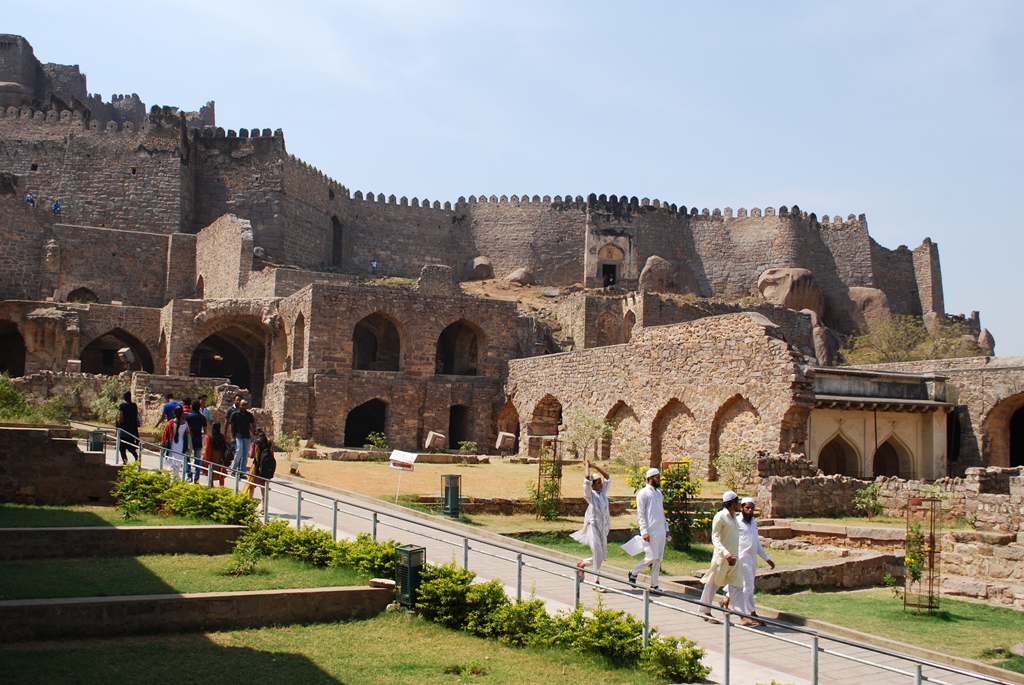
Tourists at the Fort
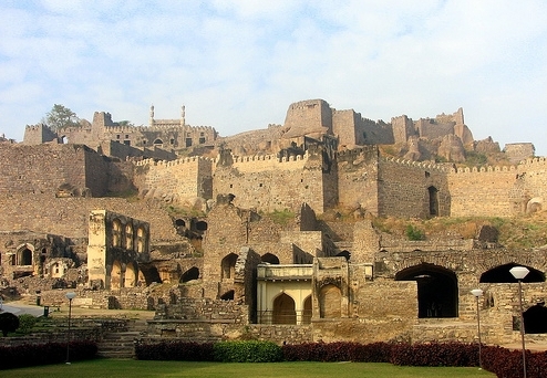
Actually the Golkonda Plan was made after seeing the Kondapalli Quilla near Vijayawada, Krishna Dt.The 13th-century Golkonda Fort was built by the Kakatiyas. It was built in 945 CE-970 CE.[2] The dynasty's name comes either from its association with a town known as Kakatipura (since the kings bore the title “Kakatipuravallabha”) or from their worship of a goddess called Kakati. A temple dedicated to goddess Kakatamma exists in Warangal so Kakatipura could be another name for Warangal itself. Kakatiyas' ancestors belonged to the Durjaya family. [3] In the 16th century, Golkonda was the capital city of the Qutb Shahi kingdom, near Hyderabad. The city was home to one of the most powerful Muslim sultanates of the region and was the flourishing center of diamond trade. The city and fortress are built on a granite hill that is 120 meters (400 ft) high and is surrounded by massive crenelated ramparts. The beginnings of the fort date to 1143, when the Hindu Kakatiya dynasty ruled the area. The Kakatiya dynasty were followed by the state of Warangal, which was later conquered by the Islamic Bahmani Sultanat. The fort became the capital of a major province in the Sultanate and after its collapse the capital of the Qutb Shahi kings. The fort finally fell into ruins after a siege and its fall to Mughal emperor Aurangazeb.
After the collapse of the Bahmani Sultanat, Golkonda rose to prominence as the seat of the Qutb Shahi dynasty around 1507. Over a period of 62 years the mud fort was expanded by the first three Qutb Shahi kings into a massive fort of granite, extending around 5 km in circumference. It remained the capital of the Qutb Shahi dynasty until 1590 when the capital was shifted to Hyderabad. The Qutb Shahis expanded the fort, whose 7 km outer wall enclosed the city. The state became a focal point for Shia Islam in India, for instance, in the 17th century, Bahraini clerics, Sheikh Ja`far bin Kamal al-Din and Sheikh Salih Al-Karzakani both emigrated to Golkonda.[4]
The Qutb Shahi sultanate lasted until its conquest by Mughal emperor Aurangzeb in 1687. The fortress held out against Aurangzeb for nine months, falling to the Mughals through treachery.
Diamonds[]

Darya-ye Noor Diamond

Hope Diamond
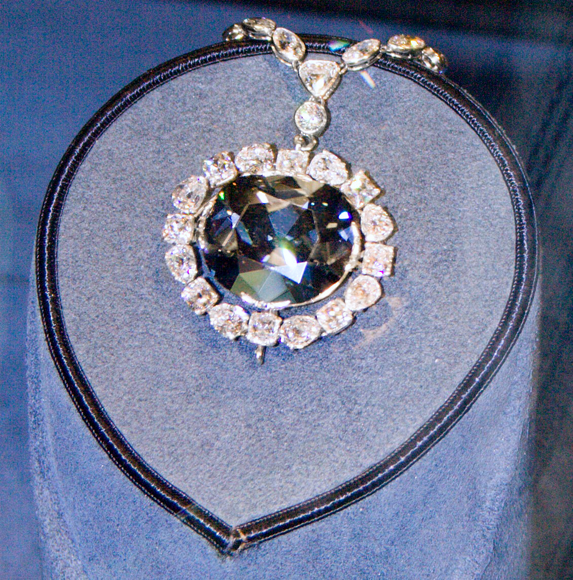
The Golkonda Fort used to have a vault where once the famous Kohinoor and Hope diamonds were stored along with other diamonds.[5]
Golkonda was once renowned for the diamonds found on the south-east at Kollur Mine near Kollur (modern day Guntur district), Paritala (modern day Krishna district) and cut in the city during the Kakatiya reign. At that time, India had the only known diamond mines in the world.
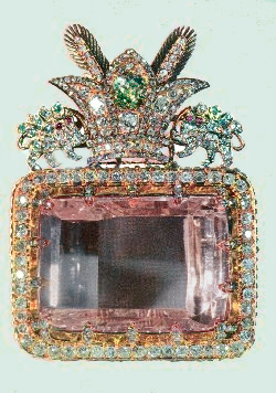
Golkonda's mines yielded few diamonds. Actually, Golkonda was the market city of the diamond trade, and gems sold there came from a number of mines. The fortress city within the walls was famous for diamond trade. However, Europeans believed that diamonds were found only in the fabled Golkonda mines. Magnificent diamonds were taken from the mines in the region surrounding Golkonda, including Darya-e Nur, meaning sea of light, at 185 carats (37.0 g), the largest and finest diamond of the crown jewels of Iran.
Its name has taken a generic meaning and has come to be associated with great wealth. Gemologists use this classification to denote a diamond with a complete (or almost-complete) lack of nitrogen; "Golkonda" material is also referred to as "2A".
Many famed diamonds are believed to have been excavated from the mines of Golkonda, such as:
- Darya-e Nur
- Nur-Ul-Ain Diamond
- The Koh-i-noor
- The Hope Diamond
- Princie Diamond
- The Regent Diamond
- Wittelsbach Diamond
By the 1880s, Golkonda was being used generically by English speakers to refer to any particularly rich mine, and later to any source of great wealth.
During the Renaissance and the early modern eras, the name "Golkonda" acquired a legendary aura and became synonymous for vast wealth. The mines brought riches to the ruling Qutb Shahis of Hyderabad State, who ruled Golkonda up to 1687, then to ruling Asaf Jah of Hyderabad State, who ruled after the independence from the Mughals in 1724, until 1948, when Hyderabad was annexed, to become an Indian state.
The Fort[]


Fort overlooking the city of Hyderabad


Highest point of the fort


A complete view from top


Another view of Golkonda fort

Ruins of the Fort


Ruins of Golkonda Fort with fountain in front at dusk
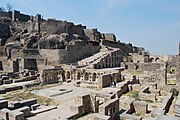
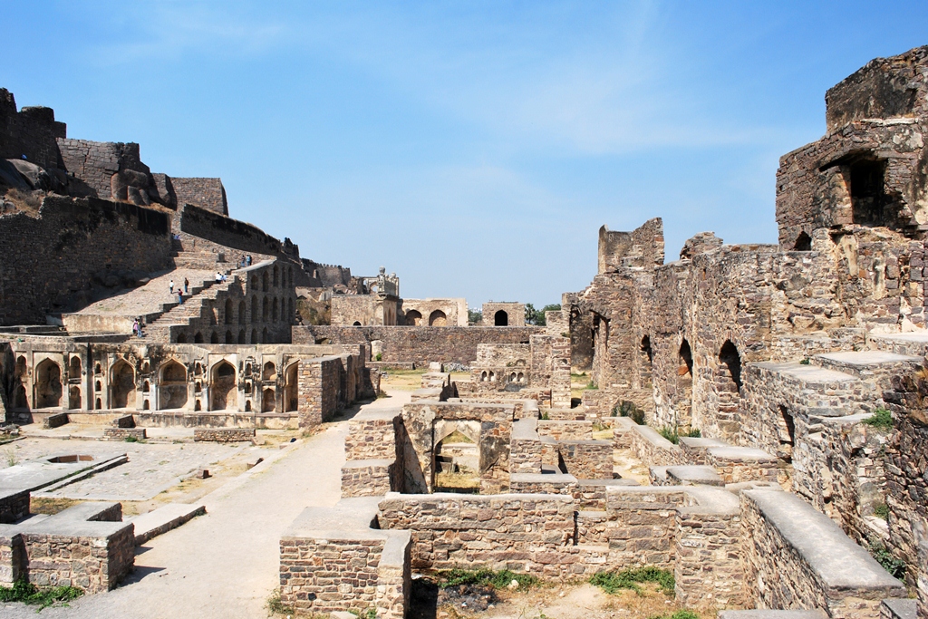
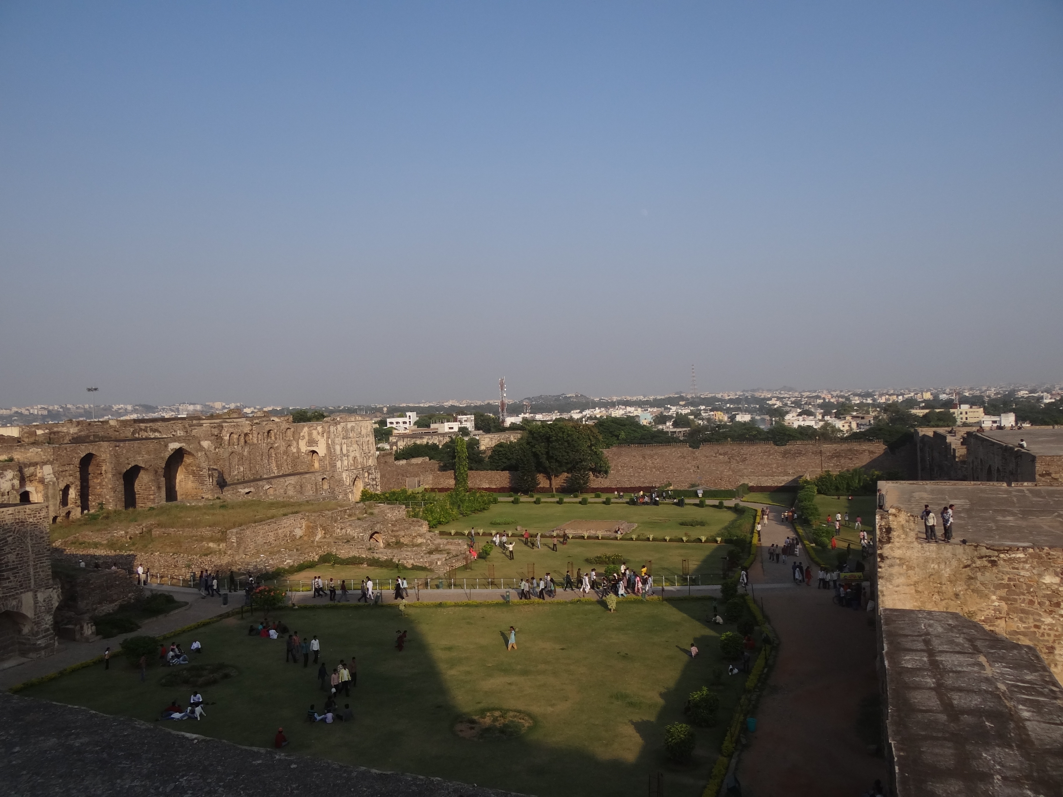
Golkonda consists of four distinct forts with a 10 km long outer wall with 87 semicircular bastions (some still mounted with cannons), eight gateways, and four drawbridges, with a number of royal apartments & halls, temples, mosques, magazines, stables, etc. inside. The lowest of these is the outermost enclosure into which we enter by the "Fateh Darwaza" (Victory gate, so called after Aurangzeb’s triumphant army marched in through this gate) studded with giant iron spikes (to prevent elephants from battering them down) near the south-eastern corner. At Fateh Darwaza can be experienced a fantastic acoustic effect, characteristic of the engineering marvels at Golkonda. A hand clap at a certain point below the dome at the entrance reverberates and can be heard clearly at the 'Bala Hisar' pavilion, the highest point almost a kilometre away. This worked as a warning note to the royals in case of an attack.
The whole of the Golkonda Fort complex and its surrounding spreads across 11 km of total area, and discovering its every nook is an arduous task. A visit to the fort reveals the architectural beauty in many of the pavilions, gates, entrances and domes. Divided into four district forts, the architectural valour still gleams in each of the apartments, halls, temples, mosques, and even stables. The graceful gardens of the fort may have lost their fragrance, for which they were known 400 years ago, yet a walk in these former gardens should be in your schedule when exploring the past glories of Golkonda Fort.
Bala Hissar Gate is the main entrance to the fort located on the eastern side. It has a pointed arch bordered by rows of scroll work. The spandrels have yalis and decorated roundels. The area above the door has peacocks with ornate tails flanking an ornamental arched niche. The granite block lintel below has sculpted yalis flanking a disc. The design of peacocks and lions is a blend of Hindu – Muslim architecture.
Toli Masjid, situated at Karwan, about 2 km from the Golkonda fort, was built in 1671 by Mir Musa Khan Mahaldar, royal architect of Abdullah Qutb Shah. The facade consists of five arches, each with lotus medallions in the spandrels. The central arch is slightly wider and more ornate. The mosque inside is divided into two halls, a transverse outer hall and an inner hall entered through triple arches.
Much thought went into building this gate. A few feet in front of the gate is a large wall. This prevented elephants and soldiers (during enemy attacks) from having a proper ramp to run and break the gate.
The fort of Golkonda is known for its magical acoustic system. The highest point of the fort is the "Bala Hissar", which is located a kilometer away. The palaces, factories, water supply system and the famous "Rahban" cannon, within the fort are some of the major attractions. It is believed that there is a secret underground tunnel that leads from the "Durbar Hall" and ends in one of the palaces at the foot of the hill. The fort also contains the tombs of the Qutub Shahi kings. These tombs have Islamic architecture and are located about 1 km north of the outer wall of Golkonda. They are encircled by beautiful gardens and numerous exquisitely carved stones. It is also believed that there was a secret tunnel to Charminar.
The two individual pavilions on the outer side of Golkonda are also major attractions of the fort. It is built on a point which is quite rocky. The "Kala Mandir" is also located in the fort. It can be seen from the king's durbar (king's court) which was on top of the Golkonda Fort.
The other buildings found inside the fort are :
- Habshi Kamans (Abyssian arches), Ashlah Khana,Taramati mosque,Ramadas Bandikhana,Camel stable, private chambers (kilwat), Mortuary bath, Nagina bagh, Ramasasa's kotha, Durbar hall, Ambar khana etc.
This majestic structure has beautiful palaces and an ingenious water supply system. Sadly, the unique architecture of the fort is now losing its charm.
The ventilation of the fort is absolutely fabulous having exotic designs. They were so intricately designed that cool breeze could reach the interiors of the fort, providing a respite from the heat of summer.
The Huge gates of the fort are decorated with large pointed iron spikes. These spikes prevented Elephants from damaging the fort. The fort of Golkonda is encircled by a 11-km-long outer wall. This was built in order to fortify the fort.
Naya Qila (New Fort)[]

Garden from Top
Naya Qila is an extension of the Golkonda Fort opposite to it. This ramparts of this new fort starts after the residential area in between. This area is very extensive with extenstive ramparts, many towers and Haathiyaan Ka Jhaad - a very large and old Baobab Tree with an enormous girth. It also includes a war mosque. Plans are afoot by the local government to convert the area into a Golf Club.
Qutub Shahi Tombs[]
The tombs of the Qutb Shahi sultans lie about one kilometer north of Golkonda's outer wall. These structures are made of beautifully carved stonework, and surrounded by landscaped gardens. They are open to public and receive many visitors.
In culture[]
- René Magritte's painting Golconda was named after the city.
- John Keats' early poem "On receiving a curious Shell" opens with the lines: "Hast thou from the caves of Golkonda, a gem / pure as the ice-drop that froze on the mountain?"[6]
- Referenced in the classical Russian ballet, La Bayadère
Gallery[]
")
")
")
")
")
")
")
")
")
")
")
")
")
See also[]
- Afanasiy Nikitin – the first European to visit Golkonda
- Andhra Pradesh
- Asaf Jahi
- History of Hyderabad
- History of India
- Middle kingdoms of India
- Naya Qila
- Qutb Shahi dynasty
- Taramati Baradari
References[]
- ↑ Plunkett, R.; T. Cannon, P. Davis, P. Greenway and P. Harding (2001). Lonely Planet South India. Lonely Planet. p. 419. ISBN 1-86450-161-8. http://books.google.com/books?ie=UTF-8&hl=en&id=JmL9KqczbRYC. Retrieved 2006-03-05.
- ↑ Prasad G (1988). History of the Andhras up to 1565. P. G. Publishers, Guntur.
- ↑ . Majumdar, R. C (1977). Ancient India. Motilal Banarsidass. pp. 377. ISBN 81-208-0436-8.
- ↑ Juan Cole, Sacred Space and Holy War, IB Tauris, 2007, p44.
- ↑ Bradnock, Roma. Footprint India. p. 1035. ISBN 978-1-906098-05-6.
- ↑ "6. On receiving a curious Shell. Keats, John. 1884. The Poetical Works of John Keats". Bartleby.com. http://www.bartleby.com/126/6.html. Retrieved 2013-05-01.
External links[]
| Wikimedia Commons has media related to Golkonda. |
- Photos of Golconda on HyderabadPlanet.com
- Golkonda Fort Pictures
- Qutb Shahi Architecture at Golconda
- Golconda Fort pictures, 2013
| |||||
| ||||||||||||||||||||||||||||||||||||||||||||||||||||||||||||||
The original article can be found at Golkonda and the edit history here.
sa:गोल्कोण्डदुर्गम्