
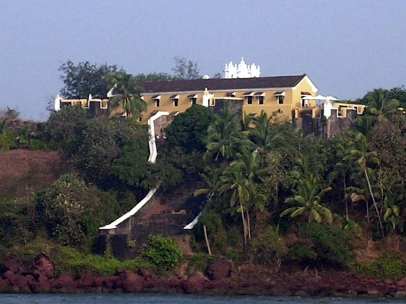
Fort Tiracol
Fort Tiracol, sometimes known as Terekhol Fort, is a fort in Goa, India. Located on the northern tip of Goa at the mouth of the Tiracol River, Fort Tiracol is reached by a ferry from Querim, 42 km North of Panaji. The name probably originated from the Marathi tir-khol meaning "steep river-bank".[1]
The fort was originally built by Maharaja Khem Sawant Bhonsle, the Raja of Sawantwadi, in the 17th century.[2] The site chosen was a hillock on the Northern (right) bank of the river, which gave a commanding view of the Arabian sea. The Bhonsles of Sawantwadi kept a sizeable fleet of native vessels which sheltered in the Tiracol River. The fort initially consisted of 12 guns, a barrack and a chapel.[3]
In 1746, the Portuguese under the 44th Viceroy of Goa, Pedro Miguel de Almeida Portugal e Vasconcelos, conde de Assumar, marquis de Alorna, waged war against the Raja of Sawantwadi. On 16 November 1746, de Almeida brought the Portuguese fleet up to the River Kaisuva, waged a fierce maritime engagement against the naval forces of the Raja of Sawantwadi in which the Portuguese defeated the Sawantwadi forces utterly. Several skirmishes on land followed and Fort Tiracol was finally surrendered on 23 November 1746 to the Portuguese.[3] The fort became an important part of Portuguese maritime defences; being extensively revamped in 1764. It remained in Portuguese control till December 1961 when the last of Portuguese territorial positions in the subcontinent were forcibly annexed by India.
On 17 February 1819, following the defeat of the Marathas, a treaty was signed by Raja Bhonsle Khaima Sawunt of Sawunt Warree who recognised British suzerainty. This treaty effectively abolished the strategic importance of the fort, as it became an enclave in territory controlled by British allies.[4]
During the Portuguese Civil War, the fort served as a rebel stronghold during an uprising in 1825 against the Portuguese led by Dr. Bernardo Peres da Silva, the first Goan born Viceroy of Goa. It was greatly damaged but the fort and the chapel were later rebuilt.[2] A ruthless Commandant, "Tiger-killer" da Cunha entered the fort and ordered the beheading of the entire garrison and the placing of the heads on stakes.[1] Fort Tiracol was a symbolic location where freedom fighters from Goa demonstrated from time to time.[1] On 15 August 1954, Satyagrahis protesting Portuguese rule entered Goa from three different directions - one of which was from the North to Fort Tiracol, which was occupied and flew the Indian flag for a day before they were captured and imprisoned.[1][5]
A Church for the Holy Trinity was constructed in the fort courtyard by de Almeida after its capture. This later became the century old Church of St. Anthony.[1] Now, in a state of ruins, Fort Tiracol has been converted into a hotel, the Fort Tiracol Heritage. The church is not open to the general public except on certain occasions, such as the annual feast that is usually held in May.[2]
")
")
")
")
")
References[]
- ↑ 1.0 1.1 1.2 1.3 1.4 Bradnock, Robert; Bradnock, Roma (2002). Footprint Goa Handbook: The Travel Guide (3rd (illustrated) ed.). Footprint handbooks. ISBN 978-1-903471-22-7. http://books.google.co.in/books?id=pWAnvOJD1qwC. Retrieved 8 February 2011.
- ↑ 2.0 2.1 2.2 "Terekhol Fort". Bharatonline.com. http://www.bharatonline.com/goa/goa-travel/pernem/terekhol-fort.html. Retrieved 13 March 2011.
- ↑ 3.0 3.1 Mhamai, S. K. (1984). Sawants of Wadi - Coastal Politics in 18th and 19th Centuries. New Delhi: Concept Publishing Company. pp. 56–58. http://books.google.co.in/books?id=kUZSHKhKJ4gC. Retrieved 13 March 2011.
- ↑ Great Britain. Foreign and Commonwealth Office (1846). British and foreign state papers, Volume 12. H.M.S.O.. p. 489. http://books.google.co.in/books?id=_5cAAAAAYAAJ&dq=editions%3Apv5UcL6Z5iAC&pg=PA489#v=onepage&q&f=false. Retrieved 13 March 2011.
- ↑ Mody, Nawaz B. (2000). Women in India's freedom struggle. Allied Publishers. p. 323. ISBN 978-81-7764-070-0. http://books.google.co.in/books?id=8RFuAAAAMAAJ&q=Terekhol+fort&dq=Terekhol+fort&hl=en&ei=t_t8TeroMoPOrQfrkJDCBQ&sa=X&oi=book_result&ct=result&resnum=10&ved=0CE4Q6AEwCTgU. Retrieved 13 March 2011.
External links[]
- Fort Tiracol - spherical panorama 360°.
| ||||||||||||||||||||||||||||||||||||||||||||||||||||||||||||||
Coordinates: Earth 15°43′50″N 73°40′55″E / 15.7306°N 73.682°E
The original article can be found at Fort Tiracol and the edit history here.