| Fort Henry | |
|---|---|
 | |
| Established | 1812 |
| Location | Kingston, Ontario, Canada |
| Website | http://www.forthenry.com |
National Historic Site of Canada | |
| Designated | 1923 |
Fort Henry (also known as Fort Henry National Historic Site) is located in Kingston, Ontario, Canada on Point Henry, a strategic point located near the mouth of the Cataraqui River where it flows into the St. Lawrence River, at the upper end of the Thousand Islands. The original fort was constructed during the War of 1812, when present-day Ontario was a British colony known as Upper Canada.[1] The fort was constructed on the high ground of Point Henry to protect the Kingston Royal Naval Dockyard (the site of the present-day Royal Military College of Canada) from a possible United States attack.[2] The fort also monitored maritime traffic on the St. Lawrence River and Lake Ontario, as the loss of this vital shipping route would have cut off supplies to Kingston and the rest of Upper Canada.
History[]
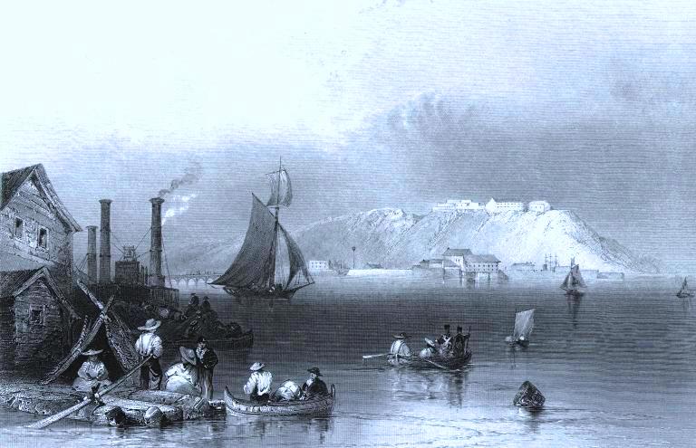
View of an early Fort Henry. Ink print, "Citadel of Kingston", by William Henry Bartlett (1809-1854)
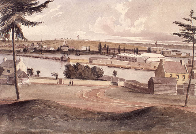
Fort Henry, Point Frederick and Tete du Pont Barracks, Kingston, from the old redoubt (1841)
The present Fort Henry was constructed between 1832 and 1837 to protect the Lake Ontario end of the Rideau Canal. (The canal was part of an alternate route between Kingston and Montreal that bypassed the St. Lawrence River, which separates Canada and the United States.) A system of more elaborate defensive works was planned but cost overruns in the construction of the canal limited the fortifications to four Martello towers and the fort itself. At the time, these fortifications were the strongest defences in Canada west of Quebec City. Among the historic regiments that garrisoned the fort were the Black Watch, the Argyll and Sutherland Highlanders and the Royal Welch Fusiliers. Neither the original nor the second Fort Henry was ever attacked.
With the Rebellions of 1838, the Royal Navy under command of Captain W. Sandom, RN and Royal Marines were on active service at Point Frederick; taking part in the battle of the Windmill at Prescott in 1839. Lieutenant Philip John Bainbrigge (1817-1881), a Royal Engineer posted to Canada from 1836 to 1842, painted "Fort Henry, Point Frederick and Tete du Pont Barracks, Kingston, from the old redoubt" (August 1841) showing the Naval Cottages, the Hospital, Stone Frigate, Point Henry and Fort Henry in the distance. The flag flying from atop the Stone Frigate indicates Sandom's HQ. After activities wound down in the following years, the Royal Naval Dockyard was closed in 1853.
The British Army withdrew in 1870 shortly after Canadian Confederation. Canadian troops then garrisoned the fort until 1891. The fort witnessed the founding of the Royal Canadian Horse Artillery, one of the first units in the Canadian Army, whose B battery was based at the fort. As relations with the United States continued to improve, the need for defences along the border ceased. During the First World War, the adjacent Barriefield Military Camp (now CFB Kingston) was established in 1914; Fort Henry served as a facility for holding German, Austrian and Turkish POWs and some civilian internees, among them Ukrainian immigrants described as "enemy aliens" during Canada's first national internment operations of 1914-1920. Abandoned by the military, the fort fell into disrepair. In the 1930s, under the leadership of Ronald L. Way, restorations took place as part of a government work program during the Great Depression. "Old Fort Henry" became a living museum with the introduction of the Fort Henry Guard, and was opened on August 1, 1938. During the Second World War, the fort served as a prisoner-of-war camp for German Luftwaffe and Kriegsmarine personnel.
Legacy[]
On 30 June 1983 Canada Post issued 'Fort Henry, Ont.' one of the 20 stamps in the “Forts Across Canada Series” (1983 & 1985). The stamps are perforated 12½ x 13 and were printed by Ashton-Potter Limited based on the designs by Rolf P. Harder.[3]
Present[]


Fort Henry Guard
Uniformed military interpreters known as the Fort Henry Guard staff the fort, conducting demonstrations of British military life and tours for visitors. There are also self-guided tours. Throughout the day there are various activities including historical reenactments of drills and battle tactics, the Garrison Parade, the Victorian School Room, and the Muster Parade, where young visitors are dressed in period uniforms and taught to march by a qualified member of the Guard. There is also a Sunset Ceremony every Wednesday and Saturday in July and August, where a full program of historic drill, music and artillery is presented. During evenings year-round, Haunted Walks of Kingston conducts tours of the Fort that take place in the dark, highlighting the Forts notably haunted past. Fort Henry was featured on the Popular Syfy network program Ghost Hunters, where members of The Atlantic Paranormal Society (also known as "TAPS") investigated for evidence of Fort Henry's notable paranormal activity. The episode was filmed in August 2009 and aired in August 2010.
Fort Henry has been designated as a National Historic Site of Canada, and in 2007 was included in the designation of the Rideau Canal as a UNESCO World Heritage Site. One can also view from Cartwright Point (the location of the Cathcart Tower).
Affiliations[]
The Museum is affiliated with: Canadian Museums Association, Canadian Heritage Information Network, and Virtual Museum of Canada.
See also[]
| Wikimedia Commons has media related to Fort Henry, Ontario. |
References[]
- ↑ "Fort Henry National Historic Site of Canada". www.pc.gc.ca. 03-05-2012. http://www.pc.gc.ca/eng/rech-srch/clic-click.aspx?/cgi-bin/MsmGo.exe?grab_id=0&page_id=2935&query=Fort%20Henry&hiword=FORTE%20FORTES%20FORTH%20FORTIN%20FORTIS%20FORTS%20FORTY%20Fort%20HENRI%20HENRYS%20Henry. Retrieved 09-24-2013.
- ↑ Cary, Henry (2003). "Early Works: Preliminary Glimpses of the First Military Complex at Fort Henry, Kingston, Ontario, 1812-1827". pp. 4–22.
- ↑ Canada Post stamp
- Ontario Heritage Plaque - Fort Henry
- Kingston Fortifications national historic site of canada Management Plan (Ottawa: Parks Canada, 2006)
- St. Lawrence Parks Commission, Le Fort Henry: La Citadelle du Haut-Canada, 1980, Kingston, Ontario.
- Mecredy, Stephen D., Fort Henry: An Illustrated History, 2000, James Lorimer and Company, Ltd., Toronto.
- Nick and Helma Mika ``Kingston Heritage, Buildings, Monuments, Plaques`` Mika Publishing, 1983, 160 pages.
- [1] - Ukrainian Canadian Civil Liberties Association
- [2] - Canadian First World War Internment Recognition Fund
External links[]
Coordinates: 44°13′48.95″N 76°27′34.85″W / 44.2302639°N 76.4596806°W
The original article can be found at Fort Henry, Ontario and the edit history here.