Fort Kamehameha was a United States Army military base that was the site of several coastal artillery batteries to defend Pearl Harbor starting in 1907 in Honolulu, Hawaii.
History
The eastern areas of the fort were in the district called Moanalua. It was royal land won by conquest by Kamehameha I in the 1790s and eventually passed to Bernice Pauahi Bishop (named "Bishop's Point") and then inherited by Samuel Mills Damon in 1884. The western side known as Halawa, was the former beach-front estate of Queen Emma of Hawaii. The sandy dunes had been used as a burial site.[1] After annexation of the Territory of Hawaii it was used for the U.S. Army in 1901, and acquired by the U.S. federal government in 1907 by condemnation from Emma's estate. It was sometimes called "Queen Emma Military Reservation" or "Queen Emma Point".
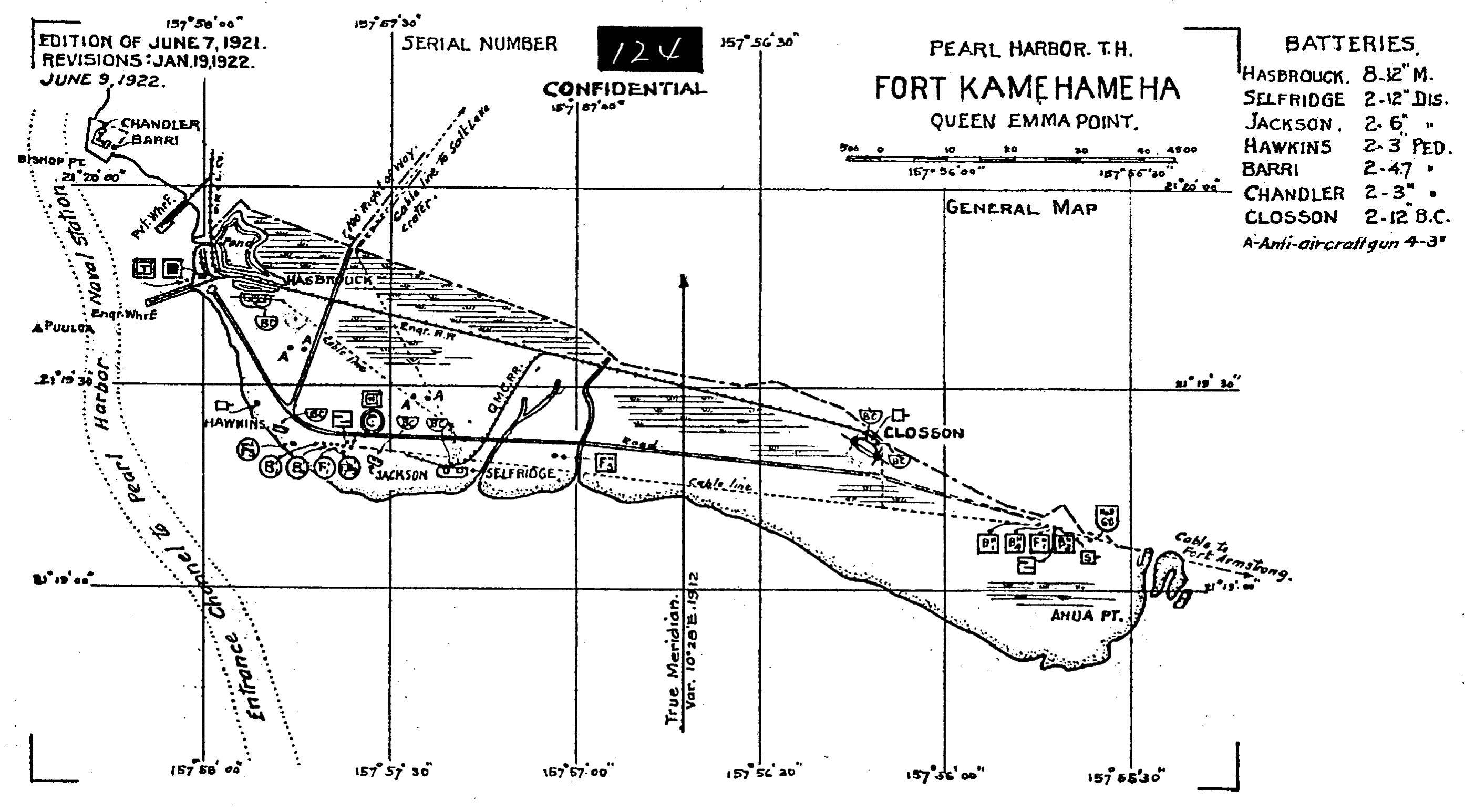
Map from 1922 of Fort Kamehameha
Secretary of war William Howard Taft under President Theodore Roosevelt headed a group to review coastal defenses, in light of "possessions" such as Hawaii and the Philippines, based on the findings of the Board of Fortifications. Originally named Fort Upton for General Emory Upton (1839–1881), on January 28, 1909 after local citizens objected, Archibald Cleghorn suggested the name be changed to honor Kamehameha I, the first king of the unified Hawaiian islands.[2]
First phase
From east to west the sites built in the first phase were:
Battery Selfridge
Battery Selfridge was constructed from November 1907 to 1913 with two 12-inch M1895 guns on disappearing carriages, with a range of about 30,000 yards (27 km).[3] It was fort building 420, NRHP site 84000975, located at 21°19′5″N 157°57′9″W / 21.31806°N 157.9525°W. It was named for Lt Thomas Etholen Selfridge (1882–1908).
Battery Jackson
Battery Jackson was constructed in 1913 was equipped with two 6-inch (150 mm) guns on disappearing carriages, with a range of about 15,000 yards (14 km).[3] It was fort building 430, about 1.1 acres (4,500 m2), state site 80-13-1601 and NRHP site 84000954, 21°19′6″N 157°57′22″W / 21.31833°N 157.95611°W. It was named for American Civil War General Richard H. Jackson. A massive concrete air raid shelter was built in 1915.[4]
Battery Hawkins
Battery Hawkins was constructed in 1914 with two 3-inch (76 mm) guns with a range of about 6,000 yards (5.5 km).[3] It was fort building 440, NRHP site 84000928 located at 21°19′12″N 157°57′36″W / 21.32°N 157.96°W, 440 Nelson Avenue. Another bunker built here was known as Hawkins annex, fort building 450, NRHP site 84000948, state site 80-13-1603. Although the smallest of the batteries, it is the easiest to access.[5] It was named for General Hamilton Smith Hawkins (1834–1910).[6]
Battery Hasbrouck
Battery Hasbrouck (sometimes misspelled as "Hasebrock") was constructed from July 1909 to 1914 and was equipped with eight 12-inch coast defense mortars, with a range of about 15,000 yards (14 km).[3] It was fort building 460 and NRHP site 84000925. It was directly east of the entrance to Pearl Harbor, designed to protect its mine field, at coordinates 21°19′30″N 157°57′40″W / 21.325°N 157.96111°W, covering 2.6 acres (11,000 m2). It was named for General Henry Cornelius Hasbrouck (1839–1910) son of William C. Hasbrouck.[7]
Battery Chandler and Barri
At the west end of Fort Kamehameha, coordinates 21°19′53″N 157°58′6″W / 21.33139°N 157.96833°W Battery Chandler had two 3-inch (76 mm) guns named for Lt. Rex Chandler who died in an airplane crash in 1913. Battery Barri had two 4.7 guns, was named for Captain Thomas O. Barri who died in the Civil War in 1863. Construction on these was started in September 1914. Barri was dismantled in 1925 and both no longer exist.[7]
Batteries Adair and Boyd
Each of these had two 6-inch (150 mm) guns in casemates located on Ford Island. They were constructed starting in August 1916 and named for Lt Henry R. Adair (died 1916) and Captain Charles T. Boyd (died 1916). A few years later an airfield called Luke Field was built on Ford Island, and the site is now owned by the Navy.[7]
Battery Closson
The batteries were placed behind massive reinforced concrete walls about 20 feet (6.1 m) thick, which were in turn behind 30 feet (9.1 m) of earth. Within a few years the armaments of the first phase were obsolete. In 1920, two 12-inch (300 mm) guns of a new style on a barbette carriage that could traverse a full 360 degrees were installed and named after Civil War General Henry Whitney Closson (1834–1917).[8] This design had a 975-pound (442 kg) projectile with elevation up to 35 degrees and range of 17 miles (27 km). It was located about 21°19′9″N 157°56′3″W / 21.31917°N 157.93417°W. Anti-aircraft guns were also added to protect from attack from above. In 1942, concrete shielding was added above the guns.[7] A row of officers' houses was built in 1916, and a chapel added in 1940.
Use

Cockpit of the "Zero" shot down in 1941 Pearl Harbor attack
World War II some of the anti-aircraft guns were used in the attack on Pearl Harbor on December 7, 1941, and a Japanese Mitsubishi A6M2 model 21 "Zero" crashed to become the first to fall into American hands.
Preservation
None of the large caliber guns were ever fired except in practice about once a year. They were salvaged after the war. Some other sites within the fort besides the ones listed above were destroyed.[9] The area around Selfridge and Jackson batteries are now used for the Hawaii Air National Guard. The eastern side of the military reservation (where Battery Closson was located) became the Mamala Bay Golf Course. The "Artillery District of Honolulu" (state historic site 80-13-1382)[10] was added to the National Register of Historic Places listings in Oahu on June 5, 1984.[11] Fort DeRussy Military Reservation Battery Randolf (which now houses a museum) was also included in the preservation effort.[12]
In 1991 a sewage treatment plant was built on the western end of the fort. (Note: the sewage treatment plant existed from before the early 1970s - former resident). On October 1, 1992 its 506 acres (205 ha) became part of Hickam Air Force Base.[13] The residents were forced out of the homes by the U.S. Air Force and the historic homes were tragically abandoned in 2008 since they were near the runway of Honolulu International Airport despite belonging on the National Register of Historic Places.[14]
See also
- U.S. Army Coast Artillery Corps
- 41st Field Artillery Regiment (United States)
- 15th Coast Artillery (United States)
References
- ↑ U.S. Army Corps of Engineers (March 1996). "Collections Summary for Fort Kamehameha, Hawaii". U.S. Army Native American Graves Protection and Repatriation Act Compliance Project, Technical Report No. 87. http://www.dtic.mil/cgi-bin/GetTRDoc?AD=ADA363659&Location=U2&doc=GetTRDoc.pdf.
- ↑ Gregg K. Kakesako (October 27, 1997). "Fort Kamehameha looks nothing like it did in 1920: The post used to guard Pearl Harbor's entrance but is now part of Hickam". http://archives.starbulletin.com/97/10/27/news/story4.html. Retrieved 2010-02-01.
- ↑ 3.0 3.1 3.2 3.3 Glen Williford, Terrance McGovern (2003). Defenses of Pearl Harbor and Oahu 1907-50. Osprey Publishing. p. 60. ISBN 978-1-84176-572-3.
- ↑ John C. Wright (April 1977). "Air Raid Shelter: Battery Jackson". Inventory of Historic Property form. http://pdfhost.focus.nps.gov/docs/NRHP/Text/84000954.pdf.
- ↑ "A Brief History of Hickam Field: Establishing A New Airfield". http://www2.hickam.af.mil/shared/media/document/AFD-070507-118.pdf.
- ↑ Jeffrey J. Gudmens (2005). Staff Ride Handbook for the Attack on Pearl Harbor, 7 December 1941: a study of defending America. Fort Leavenworth, Kansas: Combat Studies Institute. p. 80. ISBN 978-1-4289-1644-9. http://books.google.com/books?id=4MQ5rL0ThYUC&pg=PA80&lpg=PA80.
- ↑ 7.0 7.1 7.2 7.3 William H. Dorrance, (1995). "Land Defenses of O'ahu's Forts, 1908-1920". Hawaiian Journal of History. Hawaiian Historical Society. pp. 147–161. hdl:10524/622.
- ↑ "Henry Whitney Closson". Arlington National Cemetery web site. http://www.arlingtoncemetery.net/hwclosson.htm. Retrieved 2010-02-03.
- ↑ "The Harbor Defenses of Honolulu, Hawaii". The Coast Defense Study Group. http://www.cdsg.org/hawaii.htm. Retrieved 2010-02-02.
- ↑ "National and State Register of Historic Places on Oʻahu". Hawaii Department of Land and Natural Resources. June 2009. http://hawaii.gov/dlnr/hpd/register/regoahu.pdf. Retrieved 2010-02-02.
- ↑ Cite error: Invalid
<ref>tag; no text was provided for refs namednris - ↑ Alvin L. Char (November 23, 1983). "Artillery District of Honolulu nomination form". National Park Service. http://pdfhost.focus.nps.gov/docs/NRHP/Text/64000142.pdf.
- ↑ John R. K. Clark (2001). Hawai'i place names: shores, beaches, and surf sites. University of Hawaii Press. p. 76. ISBN 978-0-8248-2451-8. http://books.google.com/books?id=K6ChFt5o-qUC&pg=PA76.
- ↑ William Cole (November 5, 2008). "Group fights to preserve historic military sites". http://the.honoluluadvertiser.com/article/2008/Nov/05/ln/hawaii811050376.html. Retrieved 2010-02-02.
Further reading
- William H. Dorrance (1993). Fort Kamehameha: the story of the harbor defenses of Pearl Harbor. White Mane Publishing Company. ISBN 978-0-942597-51-6. http://books.google.com/books?id=M2_fAAAAMAAJ.
| ||||||||||||||||||||||||||
| ||||||||||||||||||||
The original article can be found at Fort Kamehameha and the edit history here.