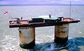
HM Fort Roughs, also known as Roughs Tower

The stages involved in sinking of the naval fort.
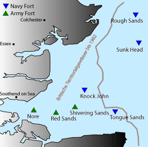
The locations of the seven Maunsell Forts off the east coast of England with HM Fort Roughs right above.
HM Fort Roughs was one of several World War II installations that were designed by Guy Maunsell and known collectively as His Majesty's Forts or as Maunsell Sea Forts, and its purpose was to guard the port of Harwich, Essex. The naval fort is situated on Rough Sands, a sandbar located approximately six miles from the coast of Suffolk and eight miles from the coast of Essex. It is today the self-proclaimed and unrecognised state, the Principality of Sealand.[1]
History
1943: Dry dock construction
Fort Roughs was constructed in 1942. It comprised a floating pontoon base with a superstructure of two hollow towers joined by a deck upon which other structures could be added. The pontoon was reinforced concrete measuring 168 by 88 feet. The fort was topped by a gun deck, an upper deck and a central tower unit which housed the radar equipment. The twin towers were divided into seven floors that provided dining and sleeping accommodation and storage areas for generators and munitions. There was a steel framework at one end supporting a landing jetty and crane which was used to hoist supplies aboard. Electricity needs were met by several generators.
On 11 February 1943 the fort was towed by three tugs to a location on Rough Sands where its base was intentionally flooded so that it sank to a resting place on the sandbar. At that time Rough Sands was situated in international waters. The superstructure of the vessel above the waterline remained visible from the coastline of England.
HM Fort Roughs was in operation within 30 minutes of being launched. The crew had been aboard during the fitting out in harbour and were well acquainted with the fort's equipment. Approximately 100 men were assigned to the barge before deployment on Rough Sands, and the facility was occupied by 150-300 Royal Navy personnel throughout World War II. At the conclusion of hostilities all original personnel were evacuated from HM Fort Roughs. The armament consisted of 3.75 inch AA guns and Bofors 40 mm guns - the standard medium and light anti-aircraft weaponry of the British and Commonwealth forces.
1956: Removal of full-time HMG personnel from Roughs Tower
British government official entities used Roughs Tower for a variety of purposes until 1956 when all full-time personnel were finally removed. Roughs Tower remained identified by name on buoys placed in position by the Ministry of Defence which are maintained under an arrangement with Trinity House. Their purpose is to warn vessels of this obstacle, especially in time of fog because busy shipping lanes criss-crossed the area with vessels going to and from the container Port of Felixstowe, Suffolk, and the Port of Harwich, Essex. UK Ordnance Survey now identify the former sea barge fort as Roughs Tower on their charts.
1966: Occupation
In 1966 Paddy Roy Bates, who operated Radio Essex, and Ronan O'Rahilly, who operated Radio Caroline, landed on Fort Roughs and occupied it. However, after disagreements, Roy Bates seized the tower as his own. O'Rahilly attempted to storm the fort in 1967, but Roy Bates defended the fort with guns and petrol bombs and continued to occupy the fort. The British Royal Marines went on alert and the British Authorities ordered Roy Bates to surrender. In his refusal, Roy Bates founded the Principality of Sealand on 2 September 1967.[2]
Location
Bob Le-Roi's Fort Fanatics webpage stated on 28 Sep 2011 that modern charts (not available online) using the WGS84 coordinates normally used for GPS, showed the fort at 51°53.71′N 1°28.83′E (i.e. 51°53′42.6″N 1°28′49.8″E). Maritime charts are normally considered more authoritative than land maps for location of maritime obstructions, so those coordinates are chosen for this article.Template:Or The fort can also be found online on UK government Ordnance Survey maps at grid reference TM3964227615, within 100 m, and on OpenStreetMap within 200 m, of the chart location 51°53′42.6″N 1°28′49.8″E / 51.895167°N 1.4805°E. OpenStreetMap notes that the structure includes a helipad.
References
- ↑ Frank Jacobs (March 20, 2012). "All Hail Sealand". The New York Times. http://opinionator.blogs.nytimes.com/2012/03/20/all-hail-sealand/.
- ↑ Ryan, John; George Dunford, Simon Sellars (2006). Micronations: The Lonely Planet Guide to Home-Made Nations. Lonely Planet. ISBN 1-74104-730-7.
Coordinates: 51°53′42.6″N 1°28′49.8″E / 51.895167°N 1.4805°E
Template:SealandNavigation
The original article can be found at HM Fort Roughs and the edit history here.