| HNoMS Svenner (G03) | |
|---|---|
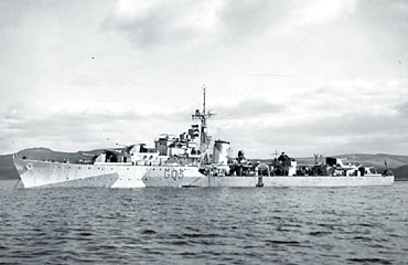 The S-class destroyer Svenner at Scapa Flow | |
| Career (Norway) | |
| Name: | Svenner |
| Namesake: | The island of Svenner |
| Builder: | Scotts, Greenock[1] |
| Laid down: | 5 November 1941 |
| Launched: | 1 June 1943 |
| Commissioned: | 11 March 1944 |
| Fate: | Sunk 6 June 1944 |
| General characteristics | |
| Class & type: | S-class |
| Displacement: | 1,710 tons (standard) |
| Length: | 363 ft (110.64 m)363 |
| Propulsion: | 40000 hp, geared turbines, 2 shafts |
| Speed: | 37 knots (68.52 km/h) |
| Complement: | 180 men |
| Armament: |
4 x 4.5 in. main guns 2 x 40 mm Bofors anti-aircraft guns 6 x 20 mm Oerlikon anti-aircraft guns 8 x 21 in. torpedo tubes |
HNoMS Svenner was an S-class destroyer in the service of the exiled Royal Norwegian Navy during World War II. She was launched on 1 June 1943 as the Royal Navy ship HMS Shark (G03), but was rechristened HNoMS Svenner when she was commissioned in the Norwegian Navy in 1944. Svenner was sunk off Sword Beach, Normandy, at dawn on 6 June 1944, while supporting the British Army landings.
HNoMS Svenner was hit by two torpedoes fired from one of two German T-boats, either Jaguar or Moewe of 5th T Flotilla operating out of Le Havre, that managed to get within firing range. The Svenner was the only allied ship to be sunk by German Naval activity on the morning of 6 June. She was struck amidships, exploded, broke in two and sank very quickly. 32 Norwegian and one British crew were killed, 185 (15 wounded) were rescued from the crew of 219. (The book D-Day by Stephen Ambrose contains a photograph, in the 16 pages of photographs after page 160, of the moment that the Svenner blew up.)
The anchor from the Svenner was recovered in 2003 and now forms 'The Svenner Memorial' at Sword Beach. The memorial can be found approximately 100 yards on the sea-side of the coast road at Hermanville-sur-Mer, Normandy, France.
See also[]
Notes[]
References[]
- Raven, Alan; Roberts, John (1978). War Built Destroyers O to Z Classes. London: Bivouac Books. ISBN 0-85680-010-4.
- Whitley, M. J. (1988). Destroyers of World War 2. Annapolis, Maryland: Naval Institute Press. ISBN 0-87021-326-1.
| ||||||||||||||||||||||||||
| |||||||||||||||||||||||
Coordinates: 49°27′N 0°15′W / 49.45°N 0.25°W
The original article can be found at HNoMS Svenner (G03) and the edit history here.