
Route of the expedition
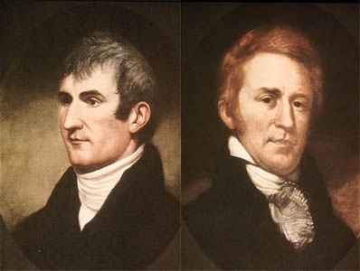
The Lewis and Clark Expedition, also known as the Corps of Discovery Expedition, was the first American expedition to cross what is now the western portion of the United States, departing in May, 1804 from St. Louis on the Mississippi River, making their way westward through the continental divide to the Pacific coast. The expedition was commissioned by President Thomas Jefferson shortly after the Louisiana Purchase in 1803, consisting of a select group of U.S. Army volunteers under the command of Captain Meriwether Lewis and his close friend Second Lieutenant William Clark. Their perilous journey lasted from May 1804 to September 1806. The primary objective was to explore and map the newly acquired territory, find a practical route across the Western half of the continent, and establish an American presence in this territory before Britain and other European powers tried to claim it. The campaign's secondary objectives were scientific and economic: to study the area's plants, animal life, and geography, and establish trade with local Indian tribes. With maps, sketches and journals in hand, the expedition returned to St. Louis to report their findings to Jefferson.[1][2]
Overview[]
According to Jefferson himself, one goal was to find "the most direct & practicable water communication across this continent, for the purposes of commerce." Jefferson also placed special importance on declaring U.S. sovereignty over the land occupied by the many different tribes of Native Americans along the Missouri River, and getting an accurate sense of the resources in the recently completed Louisiana Purchase.[3][4][5][6]
Although the expedition did make notable contributions to science,[7] scientific research itself was not the main goal of the mission.[8]
References to Lewis and Clark "scarcely appeared" in history books even during the United States Centennial in 1876 and the expedition was largely forgotten.[9][10] Lewis and Clark began to gain new attention around the start of the 20th century. Both the 1904 Louisiana Purchase Exposition, in St. Louis, and the 1905 Lewis and Clark Centennial Exposition, in Portland, Oregon, showcased Lewis and Clark as American pioneers. However, the story remained relatively shallow—a celebration of US conquest and personal adventures—until the mid-century, since which time it has been more thoroughly researched and retold in many forms to a growing audience.[9]
A complete and reliable set of the expedition's journals was finally compiled by Gary E. Moulton in 2004.[11][12][13] In the 2000s the bicentennial of the expedition further elevated popular interest in Lewis and Clark.[10] Today, no U.S. exploration party is more famous, and no American expedition leaders are more instantly recognizable by name.[9]
Preparations[]
For years Jefferson had heard of and read accounts of the various ventures of other explorers in parts of the western frontier and consequently had a long held interest in further exploring this largely still unknown region of the continent. In the 1780s, while Minister to France, Jefferson met John Ledyard in Paris and discussed a proposed trip to the Pacific Northwest.[14][15] Jefferson had also read Captain James Cook's A Voyage to the Pacific Ocean (London, 1784), an account of Cook's third voyage, and Le Page du Pratz's The History of Louisiana (London, 1763), all of which greatly influenced his decision to send an expedition. Like Captain Cook, Jefferson also wished to discover a practical route through the Northwest to the Pacific coast. However it was Alexander Mackenzie's Voyages from Montreal (1801), which informed Jefferson (who read the book at Monticello in 1802) of Britain's intent to control the lucrative fur trade of the Columbia River, and convinced him of the importance of securing the territory as soon as possible.[16][17]
Two years into his presidency, Jefferson asked Congress to fund an expedition through the Louisiana Purchase to the Pacific Ocean. He did not attempt to hide the Lewis and Clark expedition itself from Spanish, French, and British officials but obfuscated his reasons for the venture. He used a secret message to ask for funding due to poor relations with the opposition party in Congress.[18][19][20][21] In 1803, Jefferson commissioned the Corps of Discovery, and named U.S. Army Captain Meriwether Lewis its leader, who in turn selected William Clark as second in command. Lewis demonstrated remarkable skills and potential as a frontiersman. As the expedition was gaining approval and funding Jefferson made efforts to prepare him for the long journey ahead.[22] Jefferson chose Lewis to lead the expedition rather than a "qualified scientist" because, "It was impossible to find a character who to a complete science in botany, natural history, mineralogy & astronomy, joined the firmness of constitution & character, prudence, habits adapted to the woods & a familiarity with the Indian manners and character, requisite for this undertaking. All the latter qualifications Capt. Lewis has." In 1803, Jefferson sent Lewis to study medicinal cures under Benjamin Rush, a physician and humanitarian. Jefferson also arranged for Lewis to be further educated by Andrew Ellicott, an astronomer who instructed him in the use of the sextant and other navigational instruments.[23][24] Lewis however was not ignorant of science and had demonstrated to Jefferson a marked capacity to learn, especially with Jefferson as his teacher. At Monticello Jefferson possessed the largest library in the world on the subject of the geography of the North American continent, and Lewis had full access to that library. Lewis spent time consulting maps and books and conferring with Jefferson at Jefferson's library in Monticello.
Lewis and Clark met near Louisville in October 1803 at the Falls of the Ohio and before departing later in the month, the core "Nine Young Men" were enlisted into the Corps of Discovery.[25][26] Their goals were to explore the vast territory acquired by the Louisiana Purchase and to establish trade and U.S. sovereignty over the native peoples along the River Missouri. Jefferson also wanted to establish a U.S. claim of "Discovery" to the Pacific Northwest and Oregon territory by documenting an American presence there before Europeans could claim the land.[5][27][28][29] According to some historians, Jefferson understood he would have a better claim of ownership to the Pacific Northwest if the team gathered scientific data on animals and plants.[30][31] However his main objectives were centered around finding an all-water route to the Pacific coast and commerce. Before their departure Jefferson's instructions to them stated:
The object of your mission is to explore the Missouri River, & such principle stream of it, as,
by its course and communication with the waters of the Pacific ocean, whether the Columbia,
Oregon, Colorado or any other river may offer the most direct & practicable water communication
across this continent for the purpose of commerce.[32]
The U.S. mint prepared special silver medals with a portrait of Jefferson and inscribed with a message of friendship and peace, called Indian Peace Medals or peace medals. The soldiers were to distribute them to the nations they met. These symbolized U.S. sovereignty over the indigenous inhabitants. The expedition also prepared advanced weapons to display their military firepower. Among these was a .46 caliber Girandoni air rifle, a repeating rifle with a 20-round tubular magazine that was powerful enough to kill a deer.[33][34][35]
The expedition was prepared with sufficient black powder and lead for their flintlock firearms, knives, blacksmithing supplies, and cartography equipment. They also carried flags, gift bundles, medicine and other items they would need for their journey. Much time went into ensuring a sufficient supply of these items.[33][34]
The route of Lewis and Clark's expedition took them up the Missouri River to its headwaters, then on to the Pacific via the Columbia River, and may have been influenced by the purported transcontinental journey of Moncacht-Apé by the same route about a century before. Jefferson had a copy of Le Page's book detailing Moncacht-Apé's itinerary in his library, and Lewis carried a copy with him during the expedition. Le Page's description of Moncacht-Apé's route across the continent, which neglects to mention the need to cross the Rocky Mountains, may be the source of Lewis and Clark's mistaken belief that they could easily carry boats from the Missouri's headwaters to the westward-flowing Columbia.[36]
The historian John L. Loos of Louisiana State University wrote William Clark's Part in the Preparation of the Lewis and Clark Expedition, a 511-page manuscript published in 1954 by the Missouri Historical Society.[37]
Journey[]
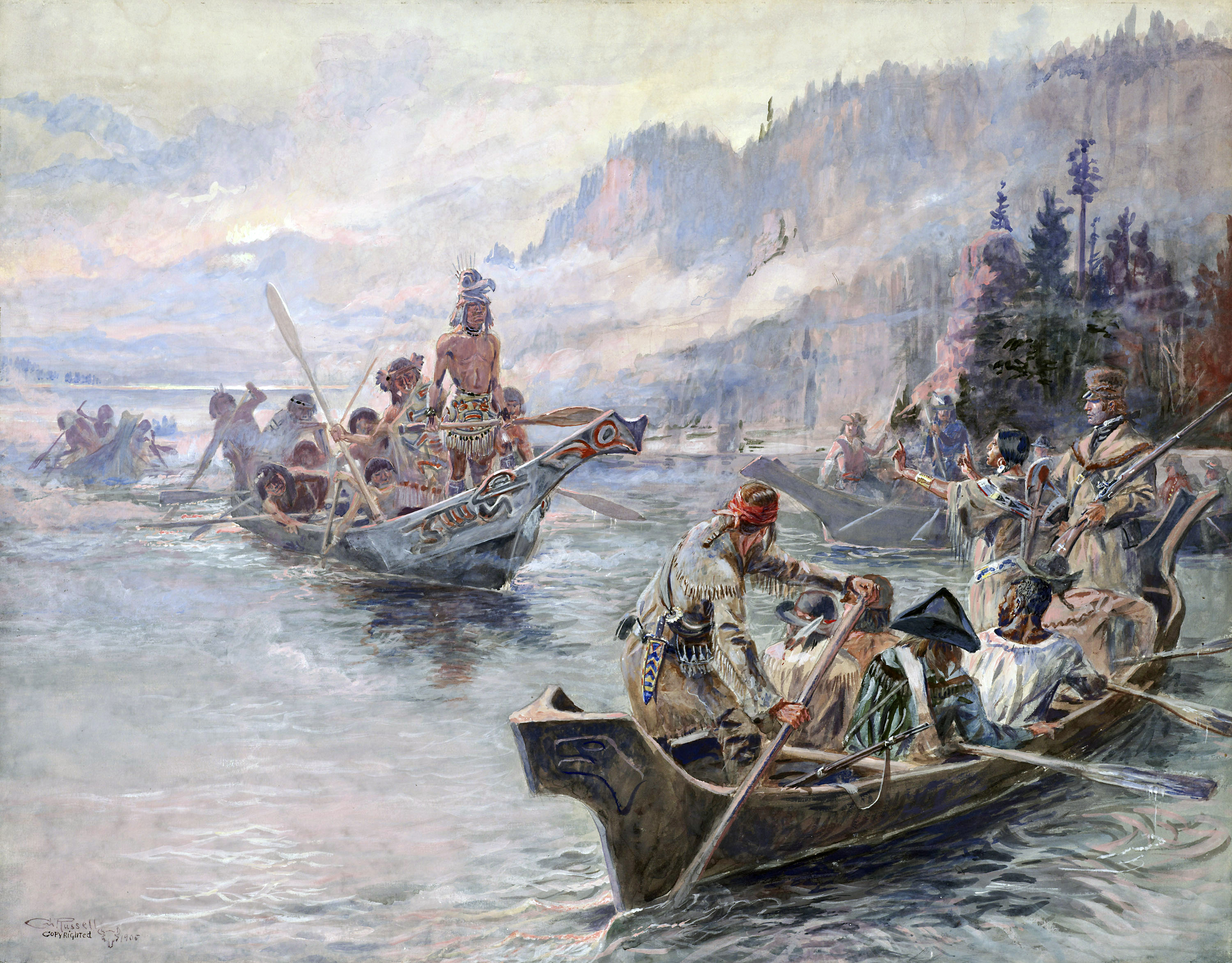
Corps of Discovery meet Chinnoks on the Lower Columbia, October 1805 (Charles Marion Russel, c.1905.)
There were 33 people, including 29 participants in training at the 1803–1804 Camp Dubois (Camp Wood) winter staging area, then in the Indiana Territory, near present day Wood River, Illinois on the east bank of the Mississippi. In March 1804, the Spanish in New Mexico learned from U.S. General James Wilkinson, later discovered to be a paid agent of the Spanish crown,[note 1] that the Americans were encroaching on territory claimed by Spain. On August 1, they sent four armed expeditions of fifty two soldiers, mercenaries, and Indians from Santa Fe northward under Pedro Vial and José Jarvet, to intercept Lewis and Clark and imprison the entire expedition. When they reached the Pawnee settlement on the Platte River in central Nebraska they learned that the expedition had been there many days before, but because the expedition at that point was covering seventy to eighty miles a day Vial's attempt to intercept them was unsuccessful.[38][39]
Departure[]
The Corps of Discovery departed from Camp Dubois at 4 p.m. on May 14, 1804, and met up with Lewis in St. Charles, Missouri, a short time later, marking the beginning of the voyage to the Pacific coast. The Corps followed the Missouri River westward. Soon they passed La Charrette, the last Euro-American settlement on the Missouri River.
The expedition followed the Missouri through what is now Kansas City, Missouri, and Omaha, Nebraska. On August 20, 1804, Sergeant Charles Floyd died, apparently from acute appendicitis. He was the only member of the expedition to die, and was among the first to sign up with the Corps of Discovery. He was buried at a bluff by the river, now named after him, in what is now Sioux City, Iowa. His burial site was marked with a cedar post on which was inscribed his name and day of death. A mile up the river the expedition camped at a small river which they named Floyd's River.[40][41][42] During the final week of August, Lewis and Clark reached the edge of the Great Plains, a place abounding with elk, deer, bison, and beavers.
The Lewis and Clark Expedition established relations with two dozen indigenous nations, without whose help the expedition would have risked starvation during the harsh winters and/or become hopelessly lost in the Rocky Mountains.[43]
The Americans and the Lakota nation (whom the Americans called Sioux or "Teton-wan Sioux") had problems when they met, and there was a concern the two sides might fight. According to Harry W. Fritz, "All earlier Missouri River travelers had warned of this powerful and aggressive tribe, determined to block free trade on the river. ... The Sioux were also expecting a retaliatory raid from the Omaha Indians, to the south. A recent Sioux raid had killed 75 Omaha men, burned 40 lodges, and taken four dozen prisoners."[44]
One of their horses disappeared, and they believed the Sioux were responsible. Afterward, the two sides met and there was a disagreement, and the Sioux asked the men to stay or to give more gifts instead before being allowed to pass through their territory. They came close to fighting several times, and both sides finally backed down and the expedition continued on to Arikara territory. Clark wrote they were "warlike" and were the "vilest miscreants of the savage race".[45][46][47][48]
In the winter of 1804–05, the party built Fort Mandan, near present-day Washburn, North Dakota. One chief asked Lewis and Clark to provide a boat for passage through their national territory. As tensions increased, Lewis and Clark prepared to fight, but the two sides fell back in the end. The Americans quickly continued westward (upriver), and camped for the winter in the Mandan nation's territory. After the expedition had set up camp, nearby Indians came to visit in fair numbers, some staying all night. For several days Lewis and Clark met in council with Mandan Indian chiefs. Here they met a French-Canadian fur trapper named Toussaint Charbonneau, and his young Shoshone wife Sacagawea. Charbonneau at this time began to serve as the expedition's translator. Peace was established between the expedition and the Mandan chiefs with the sharing of the Mandan peace pipe.[49] By April 25 Captain Lewis wrote his progress report of the expedition's activities and observations of the Indian nations they have encountered to date: A Statistical view of the Indian nations inhabiting the Territory of Louisiana which outlined the names of various tribes, their locations, trading practices and water routes used, among other things. President Jefferson would later present this report to Congress.[50]
They followed the Missouri to its headwaters, and over the Continental Divide at Lemhi Pass. In canoes, they descended the mountains by the Clearwater River, the Snake River, and the Columbia River, past Celilo Falls and past what is now Portland, Oregon at the meeting of the Willamette and Columbia Rivers. Lewis and Clark used William Robert Broughton's 1792 notes and maps to orient themselves once they reached the lower Columbia River. The sighting of Mount Hood and other stratovolcanos confirmed that the expedition had almost reached the Pacific Ocean.[51]


Reconstruction of Fort Mandan, Lewis & Clark Memorial Park, North Dakota
The expedition faced its second bitter winter, and on November 24, 1805 voted on whether to camp on the south side of the Columbia river (modern Astoria, Oregon), building Fort Clatsop. Because Sacagawea and Clark's slave York were both allowed to participate in the vote, it may have been the first time in American history where a woman and a slave were allowed to vote.[52] Lack of food was a major factor. The elk, the party's main source of food, had retreated from their usual haunts into the mountains, and the party was now too poor to purchase enough food from neighboring tribes. Lewis was determined to remain at the fort until April 1 but was anxious to move on at the earliest opportunity. By March 22 the stormy weather had subsided and the following morning the Corps began their journey homeward using canoes, and later by land.[53][54]
On July 3, before crossing the Continental Divide, the Corps split into two teams so Lewis could explore the Marias River. Lewis' group of four met some men from the Blackfeet nation. During the night, the Blackfeet tried to steal their weapons. In the struggle, the soldiers killed two Blackfeet men. Lewis, Drouillard, and the Field brothers fled over 100 miles (160 km) in a day before they camped again.
Meanwhile, Clark had entered the Crow tribe's territory. In the night, half of Clark's horses disappeared, but not a single Crow had been seen. Lewis and Clark stayed separated until they reached the Yellowstone and Missouri Rivers on August 11, along with Clark's. Before reuniting, one of Clark's hunters, Pierre Cruzatte, mistook Lewis for an elk and fired, injuring Lewis in the thigh. Once reunited, the Corps were able to return home quickly via the Missouri River. They reached St. Louis on September 23, 1806.
Return trip[]
The Corps met their objective of reaching the Pacific, mapping and establishing their presence for a legal claim to the land. They established diplomatic relations and trade with at least two dozen indigenous nations. They did not find a continuous water to the Pacific Ocean.[55] On March 23 the journey home began. They made their way to Camp Chopunnish[note 2] in Idaho, along the north bank of the Clearwater River, where the members of the expedition collected 65 horses in preparation to cross the Bitterroot Mountains, lying between modern day Idaho and western Montana. However the range was still covered in snow, which prevented the expedition from making the crossing. On April 11, while the Corps was waiting for the snow to diminish, Lewis' dog was stolen by Indians but was retrieved shortly. Worried that other such acts might follow, Lewis warned the chief that any other wrongdoing or mischievous acts would result in instant death.
Geography, science[]


Famous map of Lewis and Clark's expedition. It changed mapping of northwest America by providing the first accurate depiction of the relationship of the sources of the Columbia and Missouri Rivers, and the Rocky Mountains around 1814.
The Lewis and Clark Expedition gained an understanding of the geography of the Northwest and produced the first accurate maps of the area. During the journey, Lewis and Clark drew about 140 maps. Stephen Ambrose says the expedition "filled in the main outlines" of the area.[56]
The expedition documented natural resources and plants that had been previously unknown to Euro-Americans, though not to the indigenous peoples.[57] Lewis and Clark were the first Americans to cross the continental divide, and the first Americans to see Yellowstone, enter into Montana and produce an official description of these different regions.[58][59] Their visit to the Pacific Northwest, maps, and proclamations of sovereignty with medals and flags were legal steps needed to claim title to each indigenous nation's lands under the Doctrine of Discovery.[60]
Lewis and Clark's expedition had no greater advocate and no greater beneficiary than the American Philosophical Society (APS).[35] Their duties, as assigned by Jefferson, were preeminently scientific. Specifically, they were instructed in geography, astronomy, ethnology, climatology, mineralogy, meteorology, botany, ornithology, and zoology.[61]
The expedition recorded more than 200 plants and animals that were new to science and noted at least 72 native tribes.[62]
Jefferson had the expedition declare "sovereignty" and demonstrate their military strength to ensure native tribes would be subordinate to the U.S., as European colonizers did elsewhere. After the expedition, the maps that were produced allowed the further discovery and settlement of this vast territory in the years that followed.[63][64]
In 1807 Patrick Gass, a private in the US Army, published an account of the journey. He was promoted to Sergeant during the course of the expedition.[65] Paul Allen edited a two-volume history of the Lewis and Clark expedition that was published in 1814, in Philadelphia, but without mention of the actual author, banker Nicholas Biddle.[66] [note 3] Even then, the complete report was not made public until more recently.[67] The earliest authorized edition of the Lewis and Clark journals resides in the Maureen and Mike Mansfield Library at the University of Montana.
Encounters with Indian nations[]
One of the primary objectives of the Expedition as directed by President Jefferson was to observe and record the whereabouts, lives, activities and cultures of the various American Indian tribes that inhabited the newly acquired territory and the north west in general. The expedition encountered many different tribes along the way, many of whom offered their assistance, providing the expedition with their knowledge of the wilderness and with the acquisition of food. Along with the standard provisions of weapons, powder, tools and cooking utensils the expedition also had blank leather-bound journals and ink for the purpose of recording such encounters, as well as for scientific and geological information. They were also provided with various gifts of medals, ribbons, needles, mirrors and other artifacts which were intended to ease any tensions when negotiating their passage with the various Indian Chiefs they would encounter along their way. As many of the tribes had had previous friendly experiences with British and French fur traders in various isolated encounters along the Missouri and Columbia rivers the expedition subsequently did not encounter any hostilities with the exception of the Teton-Sioux tribe under Black Buffalo [note 4] and the Partisan tribe on September 25, 1804. Both of these tribes were rivals and hoped to use the expedition to their own advantage and who both demanded tribute from the expedition for their passage over the river at that particular juncture. Captain Lewis made his first mistake by offering the Sioux chief gifts first which insulted and angered the Partisan chief. Communication was difficult since the expedition's only Sioux interpreter, Pierre Dorion, had stayed behind with the other party and was also involved with diplomatic affairs with another tribe. Consequently both chiefs were offered a few gifts but neither was satisfied. At that point some of the warriors from the Partisan tribe then took hold of their boat and one of the oars. Lewis took a firm stand, ordering a display of force, presenting arms; Captain Clark by gesture of brandishing his sword, threatening violent reprisal. Just before the situation erupted into a violent confrontation Black Buffalo ordered his warriors to back off. After the ensuing diplomacy and with the aid of better gifts and now a bottle of whiskey, of which some was consumed, the captains were able to negotiate their passage through without further incident. During the next two days the expedition made camp not far from Black Buffalo's tribe. When they attempted to leave there were other similar incidents, but they were averted with still more gifts, this time, of tobacco.[68][69][70][71]
Observations[]
As the expedition encountered the various Indian tribes during the course of their journey they observed and recorded information regarding their lifestyles, customs and the social codes they lived by, as directed by President Jefferson. By western standards the Indian way of life seemed harsh and unforgiving as witnessed by members of the expedition. After many encounters and camping in close proximity to the Indian nations for extended periods of time during the winter months they soon learned first hand of their customs and social orders. One of the primary customs that distinguished Indian cultures from those of the West was that it was customary for the men to take on two or more wives if they were able to provide for them and often took on a wife or wives who were members of the immediate family circle. e.g.Men in the Minnetaree [note 5] and Mandan tribes would often take on a sister for a wife. Chastity among women was not held in high regard. Infant daughters were often sold by the father to men who were grown, usually for horses or mules. They learned that women in Sioux nations were often bartered away for horses or other supplies, yet this was not practiced among the Shoshone nation who held their women in higher regard.[72] They witnessed that many of the Indian nations were constantly at war with other tribes, especially the Sioux, who, while remaining generally friendly to the white fur traders, had proudly boasted and justified the almost complete destruction of the once great Cahokia nation, along with the Missouris, Illinois, Kaskaskia, and Piorias tribes that lived about the countryside adjacent to the upper Mississippi and Missouri rivers.[73]
Sacagawea[]

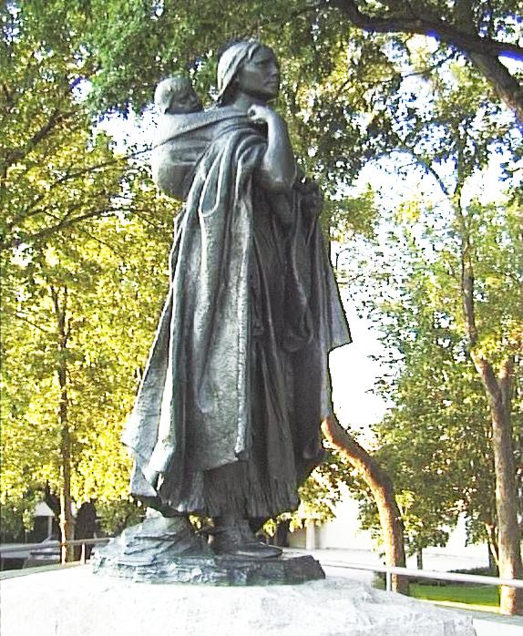
Statue of Sacagawea, a Shoshone woman who accompanied the Lewis and Clark Expedition
Sacagawea, sometimes called Sakajawea or Sakagawea (c. 1788–December 20, 1812), was a Shoshone Indian woman who arrived with her husband Toussaint Charbonneau on the expedition to the Pacific Ocean. On Feb. 11, 1805, a few weeks after her first contact with the expedition, Sacagawea went into labor and gave birth to a baby boy. Her labor was slow and painful and so the Frenchman Charbonneau, with whom she had arrived on the scene, suggested that she be given a potion of rattlesnake's rattle to aid in her delivery. Lewis happened to have some snakes rattle with him. A short time after administering the potion she delivered a healthy baby boy who was given the name Jean Baptiste Charbonneau.[74][75]
When the expedition reached Maria's River, June 16, 1805, Sacagawea became dangerously ill. She was able to find some relief by drinking mineral water from the sulphur spring that fed into the river.[76]
Though she has been discussed in literature frequently, much of the information is exaggeration or fiction. Scholars say she did notice some geographical features, but "Sacagawea...was not the guide for the Expedition, she was important to them as an interpreter and in other ways."[77] The sight of a woman and her infant son would have been reassuring to some indigenous nations, and she played an important role in diplomatic relations by talking to chiefs, easing tensions, and giving the impression of a peaceful mission.[78][79]
In his writings, Meriwether Lewis presented a somewhat negative view of her, though Clark had a higher regard for her, and provided some support for her children in subsequent years. In the journals, they used the terms "squar" and "savages" to refer to Sacagawea and other indigenous peoples.[80]
Legacy and honors[]
Since the expedition Lewis and Clark have been commemorated and honored over the years on various coins, currency and commemorative postage stamps as well as in a number of other capacities.
200th Anniversary issue U.S. postage stamp commemorating the 200th anniversary of the Expedition |   In February 1954, the 150th anniversary of the expedition's departure, Congressman Charles B. Hoeven of Iowa introduced a bill to the U.S.Congress authorizing the Lewis and Clark commemorative postage stamp. Along with Lewis and Clark the Indian woman Sacagawea and husband Toussaint Charbonneau are also depicted. |   Lewis & Clark were honored (along with the American bison) on the Series of 1901 $10 Legal Tender |
Before Lewis and Clark[]
In 1682 René-Robert Cavelier, Sieur de La Salle went down the Mississippi from the Great Lakes to the Gulf. The French then established a chain of posts along the Mississippi from New Orleans to the Great Lakes. There followed a number of French explorers including Pedro Vial and Pierre Antoine and Paul Mallet, among others. Vial may have preceded Lewis and Clark to Montana. In 1787, he gave a map of the upper Missouri River and locations of "territories transited by Pedro Vial" to Spanish authorities.[81]
Early in 1792 the American explorer Robert Gray, sailing in the Columbia Rediviva, discovered the yet to be named Columbia River, naming it after his ship and claiming it for the United States. Later in 1792, the Vancouver Expedition had learned of Gray's discovery and using maps charted by Gray, Vancouver's expedition explored over 100 miles (160 km) up the Columbia, into the Columbia River Gorge. It was the maps produced by these expeditions that Lewis and Clark used when they descended the lower Columbia to the Pacific coast.[82][83] Everything west from North Dakota to the Pacific was unknown to non-natives, except that the Rocky Mountains existed, that the upper Missouri seemed to flow from that direction, and that on the other side of the Rockies the large Columbia River entered the Pacific.[citation needed] Alexander Mackenzie had crossed North America to the Pacific from Quebec in 1792-93.[84]
See also[]
- The Red River Expedition (1806) and the Pike Expedition were also commissioned by Jefferson.
- Jefferson National Expansion Memorial
- The Far Horizons, a movie of the expedition
- York (explorer) – the slave on the expedition
- Lewis and Clark Pass (Montana) – the only non motorized pass on the expeditions route
Notes[]
- ↑ It wasn't discovered that Wilkinson was a spy until after his death in 1825
- ↑ Chopunnish was the Captain's term for the Nez Perce Pass
- ↑ An anomaly of some proportion is the fact that the 1814 account, now commonly referred to as the Biddle edition, carried no mention of Biddle anywhere. ... The only logical explanation of this incredible omission is that Biddle wanted it that way, insisted on complete anonymity.
- ↑ Commonly referred to in folk lore and various history texts as 'Crazy Horse'.
- ↑ aka the Hidatsa
References[]
- ↑ Woodger, Toropov, 2009 p.150
- ↑ Ambrose, 1996, Chap. VI
- ↑ Miller, 2006 p.108
- ↑ Fenelon & Wilson, 2006 pp.90–91
- ↑ 5.0 5.1 Lavender, 2001 pp.32, 90
- ↑ Ronda, 1984 pp.82, 192
- ↑ Fritz, 2004 p.113
- ↑ Ronda, 1984 p.9
- ↑ 9.0 9.1 9.2 Ronda, 1984 pp.327–328
- ↑ 10.0 10.1 Fresonke & Spence, 2004 pp.159–162
- ↑ Moulton, 2004
- ↑ Ambrose, 1996 p.480
- ↑ Saindon, 2003 pp.vi, 1040
- ↑ Ambrose, 1996 p.69
- ↑ Gray, 2004 p.358
- ↑ DeVoto, 1997 p.xxix
- ↑ Schwantes, 1996 pp.54–55
- ↑ Rodriguez, 2002 p.xxiv
- ↑ Furtwangler, 1993 p.19
- ↑ Ambrose, 1996 p.83
- ↑ Bergon, 2003, p.xiv
- ↑ Woodger & Toropov, 2009 p.270
- ↑ Gass & MacGregor, 1807 p.7
- ↑ Ambrose, 1996 pp.79, 89
- ↑ Ambrose, 1996 p.13
- ↑ Homser, James Kendall, 1903 p.1
- ↑ Kleber, 2001 pp.509–510
- ↑ Fritz, 2004 pp.1–5
- ↑ Ronda, 1984 p.32
- ↑ Miller, 2006 pp.99–100, 111
- ↑ Bennett, 2002 p.4
- ↑ Ambrose, 1996 p.94
- ↑ 33.0 33.1 Saindon, 2003 pp.551–552
- ↑ 34.0 34.1 Miller, 2006 p.106
- ↑ 35.0 35.1 Woodger, Toropov, 2009 pp.104, 265, 271 Cite error: Invalid
<ref>tag; name "Woodger104" defined multiple times with different content - ↑ Lavender, 2001 pp.30–31
- ↑ John L. Loos, William Clark's Part in the Preparation of the Lewis and Clark Expedition. Missouri Historical Society. http://books.google.com/books/about/William_Clark_s_part_in_the_preparation.html?id=cS31GwAACAAJ. Retrieved October 3, 2011.
- ↑ Uldrich, 2004 p.82
- ↑ Ambrose, 1996 p.402
- ↑ Allen, Lewis & Clark, Vol. 1, 1916 pp.26–27
- ↑ Woodger & Toropov, 2009 p.142
- ↑ Coues, Lewis, Clark, Jefferson 1893, Vol. 1 p.79
- ↑ Fritz, 2004 p.13
- ↑ Fritz, 2004 p.14
- ↑ Fritz, 2004 pp.14–15
- ↑ Ambrose, 1996 p.170
- ↑ Ronda, 1984 pp.27, 40
- ↑ Lavender, 2001 p.181
- ↑ Clark & Edmonds, 1983 p.12
- ↑ Allen, Lewis & Clark, Vol.1, 1916 pp.81–82
- ↑ Elin Woodger; Brandon Toropov (1 January 2009). Encyclopedia of the Lewis and Clark Expedition. Infobase Publishing. pp. 244–245. ISBN 978-1-4381-1023-3. http://books.google.com/books?id=8vYA0zDFy_IC&pg=PA244. Retrieved 28 August 2013.
- ↑ Clark & Edmonds, 1983 pp.51–52
- ↑ Ambrose, 1996 p.334
- ↑ Coues, Lewis, Clark, Jefferson 1893 pp.902–904
- ↑ Fritz, 2004 pp.33–35
- ↑ Ambrose, 1996 p.483
- ↑ Fritz, 2004 p.60
- ↑ Ambrose, 1996 p.409
- ↑ Woodger & Toropov, 2009 p.99
- ↑ DeVoto, 1997 p.552
- ↑ Fritz, 2004 p.59
- ↑ Uldrich, 2004 p.37
- ↑ Fresonke & Spence, 2004 p.70
- ↑ Fritz, 2004 p.88
- ↑ Gass & MacGregor, 1807 pp.iv, 3
- ↑ Ambrose, 1996 pp.479–480
- ↑ Lewis and Clark Journals
- ↑ Joesphy, 2006 p.vi
- ↑ Allen, Lewis & Clark, Vol.1, 1916 p.52
- ↑ Ambrose, 1996 p.169
- ↑ Woodger & Toropov, 2009 pp.8, 337–338
- ↑ Coues, Lewis, Clark, Jefferson 1893, Vol. 2 pp.557–558
- ↑ Lewis, Clark Floyd, Whitehouse, 1905 p.93
- ↑ Coues, Lewis, Clark, Jefferson 1893, Vol.1 p.229
- ↑ Clark & Edmonds, 1983 p.15
- ↑ Coues, Lewis, Clark, Jefferson 1893, Vol.1 p.377
- ↑ Clark & Edmonds, 1983 p.16
- ↑ Fritz, 2004 p.19
- ↑ Clark & Edmonds, 1983 pp.16, 27
- ↑ Ronda, 1984 pp.258–259
- ↑ Loomis & Nasatir 1967 pp.382–386, map: p.290
- ↑ Ambrose, 1996 p.70, 91
- ↑ Woodger, Toropov, 2009 pp.191, 351
- ↑ Encyclopedia Britannica: Sir Alexander Mackenzie.
Bibliography[]
- [[Paul Allen (editor)
Elliott-Madison Company |Allen, Paul]]; Clark, William; Lewis, Meriwether (1916). Meriwether Lewis and William Clarke, Volume 1. pp. 366.Ebook (full view)
- [[Stephen E. Ambrose
Simon and Schuster, New York |Ambrose, Stephen E.]] (1996). Undaunted Courage: Meriwether Lewis, Thomas Jefferson, and the Opening of the American West. pp. 511. ISBN 9780684811079. URL
- Bennett, George D. (2002). The United States Army: Issues, Background and Bibliography. pp. 229. ISBN 9781590333006. URL
- Clark, Ella E.; Edmonds, Margot (1983). Sacagawea of the Lewis and Clark Expedition
University of California Press. pp. 184. ISBN 9780520050600. URL
- Cutright, Paul Russell (2000). Contributions of Philadelphia to Lewis and Clark History. pp. 47
Lewis and Clark Trail Heritage Foundation. URL
- [[Bernard DeVoto
Houghton Mifflin Company |DeVoto, Bernard Augustine]] (1953/1997). The Journals of Lewis and Clark. pp. 504. ISBN 0-395-08380-X., URL - 2
Houghton Mifflin Harcourt (1998). The Course of Empire. pp. 647. ISBN 9780395924983. URL
- Fenelon, James; Defender-Wilson, Mary Louise (1985). Voyage of Domination, "Purchase" as Conquest, Sakakawea for Savagery: Distorted Icons from Misrepresentations of the Lewis and Clark Expedition
University of Minnesota Press. pp. Wicazo Sa Review, 85–104.URL
- Fresonke, Kris; Spence, Mark (2004). Lewis and Clark
University of California Press. pp. 290. ISBN 9780520228399. URL
- Fritz, Harry W. (2004). The Lewis and Clark Expedition,. pp. 143. ISBN 978-0-313-31661-6. URL
- Furtwangler, Albert (1993). Acts of discovery: visions of America in the Lewis and Clark journals
University of Illinois Press. ISBN 978-0-252-06306-0. URL
- [[Patrick Gass
Mountain Press Publishing |Gass, Patrick]]; MacGregor, Carol Lynn (1807). The Journals of Patrick Gass: Member of the Lewis and Clark Expedition. pp. 447. ISBN 9780878423514. URL
- Gray, Edward (2004). "Visions of Another Empire: John Ledyard, an American Traveler across the Russian Empire, 1787–1788;
Journal of the Early Republic, Vol. 24, No. 3". ; University of Pennsylvania Press. URL
- Josephy, Alvin M., Jr.,; Marc, Jaffe, eds (2006). Lewis and Clark Through Indian Eyes. pp. 196. ISBN 9781400042678. URL <-- Joesphy, 2006 pp.xx-xy</ref> -->
- Kleber, John (2001). The encyclopedia of Louisville
University Press of Kentucky. pp. 509. ISBN 978-0-8131-2100-0. URL
- Lavender, David Sievert (2001). The Way to the Western Sea: Lewis and Clark Across the Continent. pp. 444. ISBN 9780803280038. URL
- Loomis, Noel M; Nasatir, Abraham P (1967). Pedro Vial and the Roads to Santa Fe
University of Oklahoma Press. ISBN 9780806111100. URL
- Miller, Robert J. Miller (2006). Native America, Discovered And Conquered: Thomas Jefferson, Lewis & Clark, And Manifest Destiny. pp. 240. ISBN 9780275990114. URL
- Saindon, Robert A. (2003). Explorations Into the World of Lewis and Clark, Volume 3. pp. 528
Digital Scanning Inc. ISBN 9781582187655. URL
- Schwantes, Carlos. The Pacific Northwest: an interpretive history. pp. 568. ISBN 978-0-8032-9228-4. URL
- Rodriguez, Junius (2002). The Louisiana Purchase: a historical and geographical encyclopedia , , page=513. ISBN 978-1-57607-188-5. URL
- Ronda, James P. (1984). Lewis & Clark among the Indians. pp. 310. ISBN 9780803289901. URL
- Uldrich, Jack (2004
AMACOM Div American Mgmt Assn.). Into the unknown: leadership lessons from Lewis & Clark's daring westward adventure. pp. 245. ISBN 0-8144-0816-8. URL
- Woodger, Elin; Toropov, Brandon (2009). Encyclopedia of the Lewis and Clark Expedition. pp. 438. ISBN 0-8160-4781-2. URL
Primary sources[]
- Lewis, Meriwether; Clark, William (2004). The Journals Of Lewis And Clark. pp. 312. ISBN 9781419167997. URL, Full view
- Lewis, Meriwether; Clark, William; Floyd, Charles; Whitehouse, Joseph (1905).
Original Journals of the Lewis and Clark Expedition, 1804-1806, V.6. pp. 280. Ebook (full view)
- Lewis, Meriwether; Clark, William (2003). Bergon, Frank. ed. The Journals of Lewis & Clark
Penguin. pp. 560. ISBN 9780142437360. URL
- [[James Kendall Hosmer
A. C. McClurg & Company, Chocago |Lewis, William]]; Clark, Clark (1903). Hosmer, James Kendall. ed. History of the Expedition of Captain Lewis and Clark, 1804-5-6, Volume 1. pp. 500. Ebook (full view)
Francis P. Harper, New York Lewis, Meriwether; Clark, William; Jefferson, Thomas (1893).
History of the expedition under the command of Lewis and Clark:...Volume 1. pp. 1364. -- Ebook (full view)
- 2
Francis P. Harper, New York Lewis, Meriwether; Clark, William; Jefferson, Thomas (1893).
History of the expedition under the command of Lewis and Clark:...Volume 2. pp. 1364. -- Ebook (full view)
History of the expedition under the command of Lewis and Clark:...Volume 3. pp. 1298. -- Ebook (full view)
History of the expedition under the command of Lewis and Clark:...Volume 4. pp. 1298. -- Ebook (full view)
- Jackson, Donald Dean (1962). Letters of the Lewis and Clark Expedition: with related documents, 1783-1854. pp. 728. URL
- Lewis, Meriwether; Clark, William (2004). Moulton, Gary E.. ed.
The Definitive Journals of Lewis & Clark. pp. 357. ISBN 9780803280328. URL
Further reading[]
- Bassman, John H. (2009). A Navigation Companion for the Lewis & Clark Trail. Volume 1, History, camp locations and daily summaries of expedition activities. John H. Bassman.
- Betts, Robert B. (2002). In Search of York: The Slave Who Went to the Pacific With Lewis and Clark. ISBN 0-87081-714-0.
- Online text of The Journals of Lewis and Clark, 1804–1806 by William Clark and Meriwether Lewis at Project Gutenberg
- Burns, Ken (1997). Lewis & Clark: The Journey of the Corps of Discovery. ISBN 0-679-45450-0.
- Hayes, Derek (1999). Historical Atlas of the Pacific Northwest: Maps of Exploration and Discovery: British Columbia, Washington, Oregon, Alaska, Yukon. pp. 208. ISBN 9781570612152. URL
- Gilman, Carolyn (2003). Lewis and Clark: Across the Divide. Smithsonian Books
Washington, D.C.. ISBN 9781588340993., Book - Schmidt, Thomas (2002). National Geographic Guide to the Lewis & Clark Trail. ISBN 0-7922-6471-1.
- "Why Sacagawea Deserves the Day Off and Other Lessons from the Lewis and Clark Trail" by Stephenie Ambrose Tubbs (University of Nebraska Press, 2008)
- Wheeler, Olin Dunbar (1904). The Trail of Lewis and Clark, 1804–1904: A Story of the Great Exploration Across the Continent in 1804–6.... G.P. Putnam's Sons
New York. pp. 377. URL
External links[]
| Wikimedia Commons has media related to Lewis and Clark Expedition. |
- Full text of the Lewis and Clark journals online – edited by Gary E. Moulton, University of Nebraska–Lincoln
- "National Archives photos dating from the 1860s–1890s of the Native cultures the expedition encountered". Archived from the original on 2008-02-12. http://web.archive.org/web/20080212142331/http://lewisandclarkjournals.unl.edu/images2.html.
- Lewis and Clark Expedition, a National Park Service Discover Our Shared Heritage Travel Itinerary
- "History of the Expedition Under the Command of Captains Lewis and Clark: To the Sources of the Missouri, thence Across the Rocky Mountains and down the River Columbia to the Pacific Ocean" published in 1814; from the World Digital Library
- Lewis & Clark Fort Mandan Foundation: Discovering Lewis & Clark
The original article can be found at Lewis and Clark Expedition and the edit history here.