The Marshall Islands, officially the Republic of the Marshall Islands (Marshallese language: Aolepān Aorōkin M̧ajeļ),[note 1] is an island country located in the northern Pacific Ocean. Geographically, the country is part of the larger island group of Micronesia, with the population of 68,480 people spread out over 24 low-lying coral atolls, comprising 1,156 individual islands and islets. The islands share maritime boundaries with the Federated States of Micronesia to the west, Wake Island to the north,[note 2] Kiribati to the south-east, and Nauru to the south. The most populous atoll is Majuro, which also acts as the capital.
Micronesian colonists gradually settled the Marshall Islands during the 2nd millennium BC, with inter-island navigation made possible using traditional stick charts. Islands in the archipelago were first explored by Europeans in the 1520s, with Spanish explorer Alonso de Salazar sighting an atoll in August 1526. Other expeditions by Spanish and English ships followed,with the islands' current name stemming from British explorer John Marshall. Recognised as part of the Spanish East Indies in 1874, the islands were sold to Germany in 1884, and became part of German New Guinea in 1885. The Empire of Japan occupied the Marshall Islands in World War I, which were later joined with other former German territories in 1919 by the League of Nations to form the South Pacific Mandate. In World War II, the islands were conquered by the United States in the Gilbert and Marshall Islands campaign. Along with other Pacific Islands, the Marshall Islands were then consolidated into the United-States-governed Trust Territory of the Pacific Islands. Self-government was achieved in 1979, and full sovereignty in 1986, under a Compact of Free Association with the United States.
Politically, the Marshall Islands is a presidential republic in free association with the United States, with the US providing defense, funding grants, and access to social services. Having few natural resources, the islands' wealth is based on a service economy, as well as some fishing and agriculture, with a large percentage of the islands' gross domestic product coming from United States aid. The country uses the United States dollar as its currency. The majority of citizens of the Marshall Islands are of Marshallese descent, with small numbers of immigrants from the Philippines and other Pacific islands. The two official languages are Marshallese, a member of the Malayo-Polynesian languages, and English. Almost the entire population of the islands practises some religion, with three-quarters of the country either following the United Church of Christ – Congregational in the Marshall Islands (UCCCMI) or the Assemblies of God.
History
The Marshall Islands were settled by Micronesians in the 2nd millennium BC. Little is known of this early history. People traveled by canoe between islands using traditional stick charts.[1]
Spanish exploration
Spanish explorer Alonso de Salazar was the first European to see the islands in 1526, commanding the ship Santa Maria de la Victoria, the only surviving vessel of the Loaísa Expedition. On August 21, he sighted an island at 14°N that they named "San Bartolome" (probably Taongi).[2]
On September 21, 1529, Álvaro de Saavedra Cerón commanded the Spanish ship Florida, on his second attempt to recross the Pacific from the Maluku Islands. He stood off a group of islands from which several natives came off and hurled stones at his ship. These islands, named by him "Los Pintados," may have been Ujelang. On October 1, he found another group of islands where he went ashore for eight days, exchanged gifts with natives and took on water. These islands, "Los Jardines," could be Eniwetok or Bikini Atoll.[3][4]
The Spanish ship San Pedro and two other vessels in an expedition commanded by Miguel Lopez de Legazpi on January 9, 1530, discovered an island at 10°N where they went ashore and traded with natives and named it "Los Barbudos" (possibly Mejit). On January 10, they sighted another island that they named "Placeres" (perhaps Ailuk), ten leagues away, they sighted another island that they called "Pajares" (perhaps Jemo). On January 12, they sighted another island at 10°N which they called "Corrales" (possibly Wotho). On January 15, another low island was sighted at 10°N (perhaps Ujelang) where they made a good description of the people on "Barbudos."[5][6] After that, ships like San Jeronimo, Los Reyes, Todos los Santos also visited the islands in different years.
Other european exploration
Captain John Charles Marshall together with Thomas Gilbert came to the islands in 1788. The islands were named after John Marshall by Russian and French explorers Adam Johann von Krusenstern and Louis Isidore Duperrey who drew maps circa 1820 and later on English maps.[citation needed]The islands were claimed under the Spanish sovereignty as part of the Spanish East Indies. In 1874, Spanish sovereignty was recognized by the international community. Spain sold the island to Germany in 1884 through papal mediation.
German protectorate
Although Spain had a residual claim on the Marshalls in 1874, when she began asserting her sovereignty over the Carolines, she made no effort to prevent Germany from gaining a foothold there. Britain in turn raised no objection to a German protectorate over the Marhsalls in exchange for German recognition of Britain's rights in the Gilbert and Ellice Islands.[7] On October 13, 1885, the SMS Nautilus under Captain Rötger landed at Jaluit and signed a treaty with Kabua, whom the Germans had earlier recognised as "King of the Ralik Islands", on October 15. The treaty in German and Marshallese was subsequently adhered to by other chiefs (on seven other islands) and a final copy witnessed by Rötger on November 1 was sent to the Foreign Office.[8] A sign declaring "Imperial German Protectorate" was erected at Jaluit. It has been speculated that the crisis over the Carolines with Spain, which almost provoked a war, was in fact "a feint to cover the acquisition of the Marshall Islands", which went almost unnoticed at the time, despite their being the largest source of copra in Micronesia.[9]
A German trading company, the Jaluit Gesellschaft, administered the islands from 1887 until 1905. After the German–Spanish Treaty of 1899, in which Germany acquired the Carolines, Palau and Marianas, it placed all of its Micronesian islands, including the Marshalls, under the governor of German New Guinea.
Japanese mandate
Under German control, and even before then, Japanese traders and fishermen from time to time visited the Marshall Islands, although contact with the islanders was irregular. After the Meiji Restoration (1868), the Japanese government adopted a policy of turning Japan into a great economic and military power in East Asia.
In 1914, Japan joined the Entente during World War I, and captured various German colonies including several in Micronesia. On September 29, 1914, Japanese troops occupied the Enewetak Atoll, and on September 30, 1914, the Jaluit Atoll, the administrative center of the Marshall Islands.[10] After the war, on June 28, 1919, Germany renounced all of its Pacific possessions, including the Marshall Islands. On December 17, 1920, the Council of the League of Nations approved the mandate for Japan to take over all former German colonies in the Pacific Ocean located north of the equator.[10] The Administrative Center of the Marshall Islands atoll remained Jaluit.
The German Empire had primarily economic interests in Micronesia. The Japanese interests were in land. Despite the Marshalls small area and few resources, the absorption of the territory by Japan would to some extent alleviate Japan's problem of an increasing population with a diminishing amount of available land to house it.[11] During its years of colonial rule, Japan moved more than 1,000 Japanese to the Marshall Islands although they never outnumbered the indigenous peoples as they did in the Mariana Islands and Palau.
The Japanese enlarged administration and appointed local leaders, which weakened the authority of local traditional leaders. Japan also tried to change the social organization in the islands from Matrilineality to the Japanese Patriarchal system, but with no success.[11] Moreover, during the 1930s, one third of all land up to the high water level was declared the property of the Japanese government. On the archipelago, before it banned foreign traders, the activities of Catholic and Protestant missionaries were allowed.[11] Indigenous people were educated in Japanese schools, and studied Japanese language and Japanese culture. This policy was the government strategy not only in the Marshall Islands, but on all the other mandated territories in Micronesia. On March 27, 1933, Japan left the League of Nations, but continued to manage the islands, and in the late 1930s began building air bases on several atolls. The Marshall Islands were in an important geographical position, being the easternmost point in Japan's defensive ring at the beginning of World War II.[11][12]
World War II
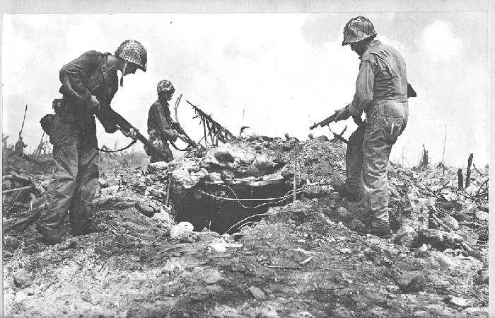
US troops inspecting an enemy bunker, Kwajalein Atoll. 1944.
In the months before the attack on Pearl Harbor, Kwajalein Atoll was the administrative center of the Japanese 6th Fleet Forces Service, whose task was the defense of the Marshall Islands.[13]
In World War II, the United States, during the Gilbert and Marshall Islands campaign, invaded and occupied the islands in 1944, destroying or isolating the Japanese garrisons. The US government added the archipelago to the U.S. Trust Territory of the Pacific Islands, along with several other island groups in the South Sea.
The battle in the Marshall Islands caused irreparable damage, especially on Japanese bases. During the American bombing, the islands' population suffered from lack of food and various injuries.
U.S. attacks started in mid-1943, and caused half the Japanese garrison of 5,100 people in the atoll Mili to die from hunger by August 1945.[14] In just one month in 1944, Americans captured Kwajalein Atoll, Majuro and Enewetak, and in the next two months the rest of the Marshall Islands except Wotje, Mili, Maloelap and Jaluit.

Shipping Lane Patrol Kwajalein Island (Marshall Islands-April 1945)
Nuclear tests after World War II

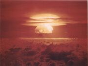
Mushroom cloud from the largest nuclear test the United States ever conducted, Castle Bravo.
From 1946 to 1958, as the site of the Pacific Proving Grounds, the U.S. tested 67 nuclear weapons in the Marshall Islands,[15] including the largest nuclear test the U.S. ever conducted, Castle Bravo.[16] In 1956, the Atomic Energy Commission regarded the Marshall Islands as "by far the most contaminated place in the world".[17]
Nuclear claims between the U.S. and the Marshall Islands are ongoing, and health effects from these nuclear tests linger.[16] Project 4.1 was a medical study conducted by the United States of those residents of the Bikini Atoll exposed to radioactive fallout. From 1956 to August 1998, at least $759 million was paid to the Marshallese Islanders in compensation for their exposure to U.S. nuclear testing.[18]
With the 1952 test of the first U.S. hydrogen bomb, code named "Ivy Mike", the island of Elugelab in the Enewetak atoll was destroyed.
Independence
In 1979, the Government of the Marshall Islands was officially established and the country became self-governing.
In 1986, the Compact of Free Association with the United States entered into force, granting the Republic of the Marshall Islands (RMI) its sovereignty. The Compact provided for aid and U.S. defense of the islands in exchange for continued U.S. military use of the missile testing range at Kwajalein Atoll. The independence procedure was formally completed under international law in 1990, when the UN officially ended the Trusteeship status.
Government


The Marshall Islands Capitol building
The government of the Marshall Islands operates under a mixed parliamentary-presidential system as set forth in its Constitution.[19] Elections are held every four years in universal suffrage (for all citizens above 18), with each of the twenty-four constituencies (see below) electing one or more representatives (senators) to the lower house of RMI’s bicameral legislature, the Nitijela. (Majuro, the capital atoll, elects five senators.) The President, who is head of state as well as head of government, is elected by the 33 senators of the Nitijela. Four of the five Marshallese presidents who have been elected since the Constitution was adopted in 1979 have been traditional paramount chiefs.[20]
Legislative power lies with the Nitijela. The upper house of Parliament, called the Council of Iroij, is an advisory body comprising twelve tribal chiefs. The executive branch consists of the President and the Presidential Cabinet, which consists of ten ministers appointed by the President with the approval of the Nitijela. The twenty-four electoral districts into which the country is divided correspond to the inhabited islands and atolls. There are currently three political parties in the Marshall Islands: Aelon Kein Ad (AKA), United People's Party (UPP), and United Democratic Party (UDP). Rule is shared by the UDP and the UPP. The following senators are in the legislative body:
- Ailinglaplap Atoll – Christopher J. Loeak (AKA), Ruben R. Zackhras (UDP)
- Ailuk Atoll – Maynard Alfred (UDP)
- Arno Atoll – Nidel Lorak (UPP), Gerald M. Zackios (UDP)
- Aur Atoll – Norman Matthew (UPP)
- Ebon Atoll – John M. Silk (UDP)
- Enewetak Atoll – Jack Ading (UPP)
- Jabat Island – Kessai H. Note (UDP)
- Jaluit Atoll – Rien R. Morris (UDP), Speaker Alvin T. Jacklick (UDP)
- Kili Island – Tomaki Juda (UDP)
- Kwajalein Atoll – Michael Kabua (AKA), Tony A. deBrum (AKA), Jeban Riklon (AKA)
- Lae Atoll – Rellong D. Lemari (AKA)
- Lib Island – Jerakoj Jerry Bejang (AKA)
- Likiep Atoll – Donald F. Capelle (UDP)
- Majuro Atoll – Wilfred I. Kendall (UDP), David Kramer (IND), Brenson S. Wase (UDP), Vice Speaker Alik J. Alik (UDP), 'H.E. President Christopher Loeak' (UDP)
- Maloelap Atoll – Michael Konelios (UDP)
- Mejit Island – Dennis Momotaro (UPP)
- Mili Atoll – Kejjo Bien (UPP)
- Namdrik Atoll – Mattlan Zackhras (UDP)
- Namu Atoll – Kaiboke Kabua (AKA)
- Rongelap Atoll – Kenneth Kedi (IND)
- Ujae Atoll – Frederick H. Muller (UPP)
- Utirik Atoll – Amenta Matthew (IND)
- Wotho Atoll – David Kabua (AKA)
- Wotje Atoll – Litokwa Tomeing (UPP)
Foreign affairs and defense
The Compact of Free Association with the United States gives the U.S. sole responsibility for international defense of the Marshall Islands. It allows islanders to live and work in the United States, and establishes economic and technical aid programs.
In international politics, Marshall Islands has often voted with the United States with respect to United Nations General Assembly resolutions.[21]
Geography

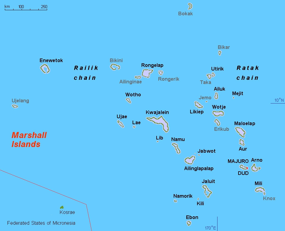
Map of the Marshall Islands


.jpg)
Beach scenery at Laura, Majuro.
The islands are located north of Nauru and Kiribati, east of the Federated States of Micronesia, and south of the U.S. territory of Wake Island, to which it lays claim.
The country consists of 29 atolls and 5 isolated islands.[22] The atolls and islands form two groups: the Ratak Chain and the Ralik Chain (meaning "sunrise" and "sunset" chains). 24 of them are inhabited (see above section). The uninhabited atolls are:
- Ailinginae Atoll
- Bikar (Bikaar) Atoll
- Bikini Atoll
- Bokak Atoll
- Erikub Atoll
- Jemo Island
- Nadikdik Atoll
- Rongerik Atoll
- Toke Atoll
- Ujelang Atoll
A majority of the islands' land mass is at sea level.
Shark sanctuary
In October 2011, the government declared that an area covering nearly 2,000,000 square kilometres (772,000 sq mi) of ocean shall be reserved as a shark sanctuary. This is the world's largest shark sanctuary, extending the worldwide ocean area in which sharks are protected from 2,700,000 square kilometres (1,042,000 sq mi) to 4,600,000 square kilometres (1,776,000 sq mi). In protected waters all shark fishing is banned and all by-catch must be released. However, the ability of the Marshall Islands to enforce this zone has been questioned.[23]
Territorial claim on Wake Island
The Marshall Islands also lays claim to Wake Island. While Wake has been administered by the United States since 1899, the Marshallese government refers to it by the name Enen-kio.
Climate
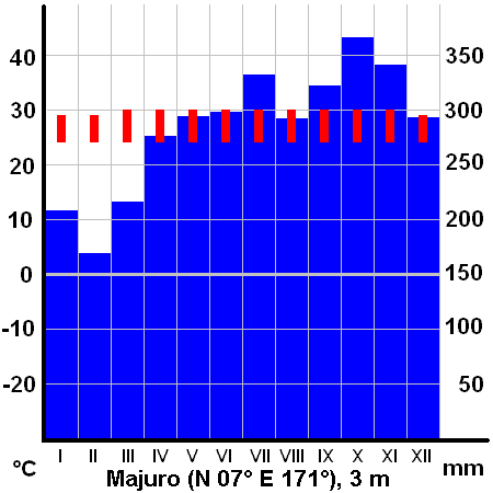
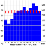
Average monthly temperatures (red) and precipitation (blue) on Majuro.
The climate is hot and humid, with a wet season from May to November. The islands occasionally suffer from typhoons. Many Pacific typhoons start in the Marshall Islands region and grow stronger as they move west toward the Mariana Islands and the Philippines.
In 2008, extreme waves and high tides caused widespread flooding in the capital city of Majuro and other urban centres, located at 1 metre (3 ft 3 in) above sea level. On Christmas morning in 2008, the government declared a state of emergency.[24] In 2013, heavy waves once again breached the city walls of Majuro. In 2013, the northern atolls of the Marshall Islands experienced drought. The drought left 6,000 people surviving on less than one litre of water per day. This resulted in the failure to grow food crops and the spread of diseases such as diarrhea, pink eye and influenza. These emergencies resulted in the United States President declaring an emergency in the MI. This declaration activated support from US government agencies, under the Republic’s ‘free association’ status with the United States, which provides humanitarian and other vital support.[25]
Following the 2013 emergencies, the Minister of Foreign Affairs Tony de Brum called for countries to turn the crises into an opportunity for climate leadership. He demanded new commitment and international leadership to stave off further climate disasters from battering his country, and other similarly vulnerable countries. This September, the Marshall Islands will host the 44th Pacific Islands Forum summit. de Brum is proposing a Majuro Declaration for Climate Leadership to galvanize concrete action on climate change.[26]
The Marshall Islands are threatened by the potential effects of storm surges as well as sea level rise.[27] According to the president of Nauru, the Marshall Islands are the nation ranked as the most endangered due to flooding from climate change.[28]
Economy


Graphical depiction of Marshall Islands's product exports in 28 color-coded categories.
The islands have few natural resources, and imports far exceed exports.
Labor
In 2007, the Marshall Islands joined the International Labor Organization, which means its labor laws will comply with international benchmarks. This may impact business conditions in the islands.[29]
Taxation
The income tax has two brackets, with rates of 8% and 12%.[citation needed][Clarification needed] The corporate tax is 3% of revenue.[citation needed] The Majuro Atoll sales tax is 4% on goods and 3% on services.[citation needed] There are no property taxes. There is an 8% import tax.[citation needed]
Foreign assistance
United States government assistance is the mainstay of the economy. Under terms of the Amended Compact of Free Association, the U.S. is committed to provide US$57.7 million per year in assistance to the Marshall Islands (RMI) through 2013, and then US$62.7 million through 2023, at which time a trust fund, made up of U.S. and RMI contributions, will begin perpetual annual payouts.[30]
The United States Army maintains the Ronald Reagan Ballistic Missile Defense Test Site on Kwajalein Atoll. Marshallese land owners receive rent for the base, and a large number[quantify] of Marshallese work there. The main airport was built by the Japanese during World War II.[citation needed]
The only tarmac road through the capital was built partly by the Taiwanese and partly by the Americans.[citation needed]
Agriculture
Agricultural production is concentrated on small farms. The most-important commercial crops are coconuts, tomatoes, melons, and breadfruit.
Industry
Small-scale industry is limited to handicrafts, fish processing, and copra.
Fishing
Fishing has been critical to the economy of this island nation since its settlement.
In 1999, a private company built a tuna loining plant with more than 400 employees, mostly women. But the plant closed in 2005, after a failed attempt to convert it to produce tuna steaks, a process that requires half as many employees. Operating costs exceeded revenue, and the plant's owners tried to partner with the government to prevent closure. But government officials personally interested in an economic stake in the plant refused to help. After the plant closed, it was taken over by the government, which had been the guarantor of a $2 million loan to the business.
Energy
On September 15, 2007, Witon Barry (of the Tobolar Copra processing plant in the Marshall Islands capital of Majuro) said power authorities, private companies, and entrepreneurs had been experimenting with coconut oil as alternative to diesel fuel for vehicles, power generators, and ships. Coconut trees abound in the Pacific's tropical islands. Copra, the meat of the coconut, yields coconut oil (1 liter for every 6 to 10 coconuts).[31] In 2009, a 57 kW solar power plant was installed, the largest in the pacific at the time, including New Zealand.[32] It is estimated that 330 kW of solar and 450 kW of wind power would be required to make the College of the Marshall Islands energy self-sufficient.[33] Marshalls Energy Company (MEC), a government entity, provides the islands with electricity. In 2008, 420 solar home systems of 200 Wp each were installed on Ailinglaplap Atoll, sufficient for limited electricity use.[34]
Demographics
There are 68,000 people living in the Marshall Islands. Most of these are Marshallese. The Marshallese are of Micronesian origin and migrated from Asia several thousand years ago. A minority of Marshallese have some recent Asian ancestry, mainly Japanese. Two-thirds of the nation's population lives on Majuro, the capital, and Ebeye, a densely populated island.[35][36][37][38] The outer islands are sparsely populated due to lack of employment opportunities and economic development. Life on the outer atolls is generally traditional.
The official language of the Marshall Islands is Marshallese, but it is common to speak the English language.[39]
Religion
Major religious groups in the Republic of the Marshall Islands include the United Church of Christ (formerly Congregational), with 51.5 percent of the population; the Assemblies of God, 24.2 percent; and the Roman Catholic Church, 8.4 percent. The Church of Jesus Christ of Latter-day Saints (Mormons), 8.3 percent;[40] Also represented are Bukot Nan Jesus (also known as Assembly of God Part Two), 2.2 percent; Baptist, 1.0 percent; Seventh-day Adventists, 0.9 percent; Full Gospel, 0.7 percent; and the Baha'i Faith, 0.6 percent.[40] Persons without any religious affiliation account for a very small percentage of the population.[40] There is also a small community of Ahmadiyya Muslims based in Majuro, with the first mosque opening in the capital in September 2012.[41]
Education
The Marshall Islands Ministry of Education operates the state schools in the Marshall Islands.[42] There are two tertiary institutions operating in the Marshall Islands – the College of the Marshall Islands[43] and The University of the South Pacific.
Transportation
The Marshall Islands are served by the Marshall Islands International Airport in Majuro, the Bucholz Army Airfield in Kwajalein, and other small airports and airstrips.
In 2005, Aloha Airlines canceled its flight services to the Marshall Islands.
Media
The Marshall Islands have several AM and FM radio stations.
AM: V7AD 1098 • 1557
FM: V7AD 97.9 • V7AA 104.1 (formerly 96.3)
AFRTS: AM 1224 (NPR) • 99.9 (Country) • 101.1 (Active Rock) • 102.1 (Hot AC)
Culture


Marshallese fans
Marshallese is used by the government. Although the ancient skills are now in decline, the Marshallese were once able navigators, using the and stick-and-shell charts.
See also
- Outline of the Marshall Islands
- Index of Marshall Islands-related articles
- List of island countries
- MIVA
- The Plutonium Files
Notes
- ↑ Pronunciations:
* English: Republic of the Marshall Islands i/ˈmɑrʃəl ˈaɪləndz/
* Marshallese: Aolepān Aorōkin M̧ajeļ ([ɑ̯ɑ͡ɒɔ̯ɔ͡ɛlʲɛbʲænʲ ɑ̯ɑ͡ɒo̯o͡ɤrˠɤɡɯ͡inʲ mˠɑɑ̯zʲɛ͡ʌɫ]) - ↑ Wake Island is claimed as a territory of the Marshall Islands, but is also claimed as an unorganized, unincorporated territory of the United States, with de facto control vested in the Office of Insular Affairs.
References
- ↑ The History of Mankind by Professor Friedrich Ratzel, Book II, Section A, The Races of Oceania page 165, picture of a stick chart from the Marshall Islands. MacMillan and Co., published 1896.
- ↑ Sharp, pp. 11–3
- ↑ Wright 1951: 109–10
- ↑ Sharp, pp. 19–23
- ↑ Filipiniana Book Guild 1965: 46–8, 91, 240
- ↑ Sharp, pp. 36–9
- ↑ Francis X. Hezel, The First Taint of Civilization: A History of the Caroline and Marshall Islands in Pre-colonial Days, 1521–1885 (University of Hawaii Press, 1994), 304–06.
- ↑ Dirk H. R. Spennemann, Marshall Islands History Sources No. 18: Treaty of friendship between the Marshallese chiefs and the German Empire (1885). marshall.csu.edu.au
- ↑ Francis X. Hezel (2003) Strangers in Their Own Land: A Century of Colonial Rule in the Caroline and Marshall Islands, University of Hawaii Press, pp. 45–46, ISBN 0824828046.
- ↑ 10.0 10.1 "Marshall Islands. Geographic Background". enenkio.org. Archived from the original on March 3, 2009. http://web.archive.org/web/20090303214701/http://www.enenkio.org/adobe/GeographyMarshallIslands.pdf.
- ↑ 11.0 11.1 11.2 11.3 "Marshall Islands". Pacific Institute of Advanced Studies in Development and Governance (PIAS-DG), University of the South Pacific, Suva, Fiji. http://piasdgserver.usp.ac.fj/peacenet//index.php?id=152. Retrieved June 11, 2010.[dead link]
- ↑ "History". Marshall Islands Visitors Authority. Archived from the original on March 21, 2009. http://web.archive.org/web/20090321063209/http://visitmarshallislands.com/history.htm. Retrieved June 11, 2010.
- ↑ "Marshall Islands". World Statesmen. http://www.worldstatesmen.org/Marshall_islands.htm. Retrieved June 11, 2010.
- ↑ Dirk H.R. Spennemann. "Mili Island, Mili Atoll: a brief overview of its WWII sites". http://marshall.csu.edu.au/Marshalls/html/WWII/Mili.html. Retrieved June 11, 2010.
- ↑ "Nuclear Weapons Test Map", Public Broadcasting Service
- ↑ 16.0 16.1 "Islanders Want The Truth About Bikini Nuclear Test". Japanfocus.org. http://japanfocus.org/-Yoichi-Funabashi/1576. Retrieved July 4, 2010.
- ↑ Stephanie Cooke (2009). In Mortal Hands: A Cautionary History of the Nuclear Age, Black Inc., p. 168, ISBN 978-1-59691-617-3.
- ↑ "50 Facts About Nuclear Weapons". Brookings Institution. July 19, 2011. Archived from the original on July 19, 2011. http://web.archive.org/web/20110719155737/http://www.brookings.edu/projects/archive/nucweapons/50.aspx.
- ↑ "Constitution of the Marshall Islands". Paclii.org. http://www.paclii.org/mh/legis/consol_act/cotmi363/. Retrieved July 4, 2010.
- ↑ Giff Johnson (November 25, 2010). "Huge funeral recognizes late Majuro chief". Marianas Variety News & Views. Archived from the original on July 14, 2011. http://web.archive.org/web/20110714141135/http://mvariety.com/2010112432258/local-news/huge-funeral-recognizes-late-majuro-chief.php. Retrieved November 28, 2010.
- ↑ General Assembly – Overall Votes – Comparison with U.S. vote lists Marshall Islands as in the country with the second high coincidence of votes. Micronesia has always been in the top two.
- ↑ [1]
- ↑ "Vast shark sanctuary created in Pacific". BBC News. October 3, 2011. http://www.bbc.co.uk/news/science-environment-15142472. Retrieved November 25, 2011.
- ↑ "Marshall atolls declare emergency ", BBC News, December 25, 2008.
- ↑ President Obama Signs a Disaster Declaration for the Republic of the Marshall Islands | The White House. Whitehouse.gov (June 14, 2013). Retrieved on September 11, 2013.
- ↑ NEWS: Marshall Islands call for “New wave of climate leadership” at upcoming Pacific Islands Forum Climate & Development Knowledge Network. Downloaded July 31, 2013.
- ↑ Storm Surges, Rising Seas Could Doom Pacific Islands This Century April 12, 2013 ClimateWire and Scientific American
- ↑ Stephen, Marcus (November 14, 2011). "A sinking feeling: why is the president of the tiny Pacific island nation of Nauru so concerned about climate change?". New York Times Upfront. http://upfront.scholastic.com/news/2011/11/a-sinking-feeling. Retrieved July 17, 2013.
- ↑ "Republic of the Marshall Islands becomes 181st ILO member State". Ilo.org. July 6, 2007. http://web.archive.org/web/20080724051220/http://www.ilo.org/global/About_the_ILO/Media_and_public_information/Press_releases/lang--en/WCMS_083235/index.htm.
- ↑ "COMPACT OF FREE ASSOCIATION AMENDMENTS ACT OF 2003" (PDF). Public Law 108–188, 108th Congress. December 17, 2003. http://web.archive.org/web/20071026023104/http://www.doi.gov/oia/Firstpginfo/laws/public%20law%20108-188,%20December%2017,%202003.pdf.
- ↑ "Pacific Islands look to coconut power to fuel future growth". afp.google.com. September 13, 2007. Archived from the original on June 9, 2007. http://web.archive.org/web/20070609092458/http://afp.google.com/article/ALeqM5iwlwgv6YIwatWfk9HEp0bSjAiV-Q.
- ↑ College of the Marshall Islands. (PDF) . reidtechnology.co.nz. June 2009
- ↑ College of the Marshall Islands: Reiher Returns from Japan Solar Training Program with New Ideas. Yokwe.net. Retrieved on September 11, 2013.
- ↑ Republic of the Marshall Islands. Rep5.eu. Retrieved on September 11, 2013.
- ↑ David Vine (2006). "The Impoverishment of Displacement: Models for Documenting Human Rights Abuses and the People of Diego Garcia". pp. 21–24. http://www.wcl.american.edu/hrbrief/13/2vine.pdf.
- ↑ David Vine (January 7, 2004) Exile in the Indian Ocean: Documenting the Injuries of Involuntary Displacement. Ralph Bunche Institute for International Studies. Web.gc.cuny.edu. Retrieved on September 11, 2013.
- ↑ David Vine (2006). Empire's Footprint: Expulsion and the United States Military Base on Diego Garcia. ProQuest. p. 268. ISBN 978-0-542-85100-1. http://books.google.com/books?id=rIXdsrzWof4C.
- ↑ David Vine (2011). Island of Shame: The Secret History of the U.S. Military Base on Diego Garcia (New in Paper). Princeton University Press. p. 67. ISBN 978-0-691-14983-7. http://books.google.com/books?id=3ankJb0skpwC.
- ↑ "Marshall Islands Travel". Wwp.greenwichmeantime.com. March 11, 2010. http://wwp.greenwichmeantime.com/time-zone/pacific/marshall-islands/travel.htm. Retrieved July 4, 2010.
- ↑ 40.0 40.1 40.2 International Religious Freedom Report 2009: Marshall Islands. United States Bureau of Democracy, Human Rights and Labor (September 14, 2007). This article incorporates text from this source, which is in the public domain.
- ↑ First Mosque opens up in Marshall Islands by Radio New Zealand International, September 21, 2012
- ↑ Education. Office of the President, Republic of the Marshall Islands. rmigovernment.org. Retrieved on May 25, 2012.
- ↑ College of the Marshall Islands (CMI). Cmi.edu. Retrieved on September 11, 2013.
Bibliography
- Sharp, Andrew (1960). Early Spanish Discoveries in the Pacific.
Further reading
- Barker, H. M. (2004). Bravo for the Marshallese: Regaining Control in a Post-nuclear, Post-colonial World. Belmont, California: Thomson/Wadsworth.
- Rudiak-Gould, P. (2009). Surviving Paradise: One Year on a Disappearing Island. New York: Union Square Press.
- Niedenthal, J. (2001). For the Good of Mankind: A History of the People of Bikini and Their Islands. Majuro, Marshall Islands: Bravo Publishers.
- Carucci, L. M. (1997). Nuclear Nativity: Rituals of Renewal and Empowerment in the Marshall Islands. DeKalb: Northern Illinois University Press.
- Hein, J. R., F. L. Wong, and D. L. Mosier (2007). Bathymetry of the Republic of the Marshall Islands and Vicinity [Miscellaneous Field Studies; Map-MF-2324]. Reston, VA: U.S. Department of the Interior, U.S. Geological Survey.
- Woodard, Colin (2000). Ocean's End: Travels Through Endangered Seas. New York: Basic Books. (Contains extended account of sea-level rise threat and the legacy of U.S. Atomic testing.)
External links
- Government
- Office of the President
- Embassy of the Republic of the Marshall Islands Washington, DC official government site
- Chief of State and Cabinet Members
- General information
- Marshall Islands entry at The World Factbook
- Country Profile from New Internationalist
- Marshall Islands from UCB Libraries GovPubs
- Marshall Islands at DMOZ
- Marshall Islands from the BBC News
- News media
- Marshall Islands Journal Weekly independent national newspaper[citation needed]
- Other
- Digital Micronesia – Marshalls by Dirk HR Spennemann, Associate Professor in Cultural Heritage Management
- Plants & Environments of the Marshall Islands Book turned website by Dr. Mark Merlin of the University of Hawaii
- Atomic Testing Information
- infoplease.com
- Pictures of victims of U.S. nuclear testing in the Marshall Islands on Nuclear Files.org
- "Kenner hearing: Marshall Islands-flagged rig in Gulf oil spill was reviewed in February"
- NOAA's National Weather Service – Marshall Islands
Lat. and Long. 7°4′N 171°16′E / 7.067°N 171.267°ECoordinates: 7°4′N 171°16′E / 7.067°N 171.267°E (Majuro)
The original article can be found at Marshall Islands and the edit history here.