Coordinates: 9°07′03.61″N 79°43′12.60″W / 9.1176694°N 79.720167°W
| Panama Canal Zone Zona del Canal de Panamá | |||||||||
|---|---|---|---|---|---|---|---|---|---|
| Former territory of United States | |||||||||
| 1903–1979 | |||||||||
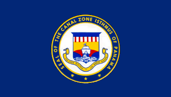 Flag
 Coat of arms
| |||||||||
| Capital | Balboa | ||||||||
| History | |||||||||
| Government | |||||||||
| • Motto | The Land Divided, The World United | ||||||||
| History | |||||||||
• Established | 1903 | ||||||||
• Disestablished | 1979 | ||||||||
| |||||||||
| Today part of | Panama | ||||||||
The Panama Canal Zone (Spanish language: Zona del Canal de Panamá ) is a 553-square-mile (1,430 km2) former unorganized U.S. territory located within the Republic of Panama consisting of the Panama Canal and an area generally extending five miles (8.0 km) on each side of the centerline, but excluding Panama City and Colón, which otherwise would have been partly within the limits of the Zone. Its border spanned two of Panama's provinces and was created on November 18, 1903, with the signing of the Hay–Bunau-Varilla Treaty. When reservoirs were created to assure a steady supply of water for the locks, those lakes were included within the Zone.
On February 26, 1904, the Isthmian Canal Convention was proclaimed. In it, the Republic of Panama granted to the United States in perpetuity the use, occupation, and control of a zone of land and land under water for the construction, maintenance, operation, sanitation, and protection of the canal.
From 1903 to 1979 the territory was controlled by the United States, which had built the canal and financed its construction. From 1979 to 1999 the canal itself was under joint U.S.–Panamanian control. In 1977 the Torrijos–Carter Treaties established the neutrality of the canal.[1]
Except during times of crisis or political tension, Panamanians could freely enter the Zone – anyone could walk across a street in Panama City and enter the jurisdiction. However, the 1903 treaty restricted the rights of Panamanians to buy at retail stores in the Zone.
During the period of U.S. control, the Canal Zone was used to support world commerce and provide daily living services to the workforce of the canal. The military personnel assigned to the Canal Zone were there primarily to defend the canal and ensure its continuous operation. The territory was also used for scientific discovery and much of the land of the Canal Zone was environmentally protected. The infrastructure of the Zone was used to provide drinking water and electricity to the cities of Colón and Panama City. According to the 1970 census, the population was 44,198, including American civilians who made up the core of permanent residents and 8,494 assigned military and local nationals working for the Panama Canal Company. The median income was $9,684 per year. Exclusive U.S. control of the Zone ended in 1979, and the full operation of the canal was turned over to Panama on December 31, 1999. The canal is a tourist destination, especially for visiting cruise ships.
The largest U.S. Army unit based in the Zone was the 193rd Infantry Brigade (Light), a mixed parachute-infantry/air-assault-capable light infantry unit. It was honored in 1994 as the first major unit to deactivate in accordance with the Panama Canal Treaty of 1977 implementation plan. The brigade was reactivated in 2007, tasked with conducting basic combat training for new U.S. Army recruits.
History[]
Proposals for a canal[]
Proposals for a canal across the Isthmus of Panama date back to 1529, soon after the Spanish conquest. Álvaro de Saavedra Cerón, a lieutenant of conquistador Vasco Núñez de Balboa, suggested four possible routes, one of which closely tracks the present-day canal. Saavedra believed that such a canal would make it easier for European vessels to reach Asia. Although King Carlos I was enthusiastic and ordered preliminary works started, his officials in Panama soon realized that such an undertaking was beyond the capabilities of 16th-century technology. One official wrote to Carlos, "I pledge to Your Majesty that there is not a prince in the world with the power to accomplish this".[2] The Spanish instead built a road across the isthmus. The road came to be crucial to Spain's economy, as treasure obtained along the Pacific coast of South America was offloaded at Panama City and hauled through the jungle to the Atlantic port of Nombre de Dios (now Colón).[3] Although additional canal building proposals were made throughout the 16th and 17th centuries, they came to naught.[2]
The late 18th and early 19th centuries saw a number of canals built. The success of the Erie Canal in the United States and the collapse of the Spanish Empire in Latin America led to a surge of American interest in building an interoceanic canal. Beginning in 1826, US officials began negotiations with New Granada (present-day Colombia and Panama), hoping to gain a concession for the building of a canal. Jealous of their newly obtained independence and fearing that they would be dominated by an American presence, New Granadan officials declined American offers. The new nation was politically unstable, and Panama rebelled several times during the 19th century.[4]
In 1836, U.S. statesman Charles Biddle reached an agreement with the New Granadan government to replace the old road with an improved one or a railroad, running from Panama City on the Pacific coast to the Chagres River, where a steamship service would allow passengers and freight to continue to Colón. His agreement was repudiated by the Jackson administration, which wanted rights to build a canal. In 1841, with Panama in rebellion again, British interests secured a right of way over the isthmus from the insurgent regime and occupied Nicaraguan ports that might have served as the Atlantic teminus of a canal.[5][6] In 1846, the new US envoy to Bogotá, Benjamin Bidlack, was surprised when, soon after his arrival, the New Granadans proposed that the United States be the guarantor of the neutrality of the isthmus. The resulting Mallarino–Bidlack Treaty allowed the United States to intervene militarily to ensure that the interoceanic road (and when it was built, the Panama Railroad as well) would not be disrupted. New Granada hoped that other nations would sign similar treaties, but the one with the United States, which was ratified by the US Senate in June 1848 after considerable lobbying by New Granada, was the only one.[7]
The treaty led the U.S. government to contract for steamship service to Panama from ports on both coasts. When the California Gold Rush began in 1848, traffic through Panama greatly increased, and New Granada agreed to allow the Panama Railroad to be constructed by American interests. This first "transcontinental railroad" opened in 1850.[8] There were riots in Panama CIty in 1856; several Americans were killed. US warships landed Marines, who occupied the railroad station and kept the railroad service from being interrupted by the unrest. The United States demanded compensation from New Granada, including a zone 20 miles (32 km) wide, to be governed by US officials and in which the United States might build any "railway or passageway" it desired. The demand was dropped in the face of resistance by New Granadan officials, who accused the United States of seeking a colony.[9]
Through the remainder of the 19th century, the United States landed troops several times to preserve the railway connection. At the same time, it pursued a canal treaty with Colombia (as New Granada was renamed). One treaty, signed in 1868, was rejected by the Colombian Senate, which hoped for better terms from the incoming Grant administration. Under this treaty, the canal would have been in the middle of a 20-mile zone, under American management but Colombian sovereignty, and the canal would revert to Colombia in 99 years. The Grant administration did little to pursue a treaty, and in 1878, the concession to build the canal fell to a French firm. The French efforts eventually failed, but with Panama apparently unavailable, the United States considered possible canal sites in Mexico and Nicaragua.[10]
The Spanish–American War of 1898 added new life to the canal debate. During the war, American warships in the Atlantic seeking to reach battle zones in the Pacific had been forced to round Cape Horn. Influential naval pundits, such as Captain Alfred Thayer Mahan, urged the construction of a Central American canal. In 1902, with the French efforts moribund, US President Theodore Roosevelt backed the Panama route, and Congress passed legislation authorizing him to purchase the French assets[11] on the condition that an agreement was reached with Colombia.[12] In March 1902, Colombia set its terms for such a treaty: Colombia was to be sovereign over the canal, which would be policed by Colombians paid for by the United States. The host nation would receive a larger percentage of the tolls than provided for in earlier draft treaties. The draft terms were quickly rejected by American officials. Roosevelt was in a hurry to secure the treaty; the Colombians, to whom the French property would revert in 1904, were not. Negotiations dragged on into 1903, during which time there was unrest in Panama CIty and Colón; the United States sent in Marines to guard the trains. Nevertheless, in early 1903, the United States and Colombia signed a treaty which, despite Colombia's previous objections, gave the United States a 6 miles (9.7 km) wide zone in which it could deploy troops with Colombian consent. On August 12, 1903, the Colombian Senate voted down the treaty 24–0.[13]
Roosevelt was angered by the Colombians' actions, especially when the Colombian Senate made a counteroffer that was more financially advantageous to Colombia. A Frenchman who had worked on his nation's canal efforts, Philippe Bunau-Varilla, represented Panamanian insurgents; he met with Roosevelt and with Secretary of State John Hay, who saw to it that his principals received covert support. When the revolution came in November 1903, the United States intervened to protect the rebels, who succeeded in taking over the province, declaring it independent as the Republic of Panama. Bunau-Varilla was initially the Panamanian representative in the United States, though he was about to be displaced by actual Panamanians, and hastily negotiated a treaty, giving the United States a zone 20 miles (32 km) wide and full authority to pass laws to govern that zone. The Panama Canal Zone (Canal Zone, or Zone) excluded Panama City and Colón, but included four offshore islands, and permitted the United States to add to the zone any additional lands needed to carry on canal operations. The Panamanians were minded to disavow the treaty, but Bunau-Varilla told the new government that if Panama did not agree, the United States would withdraw its protection and make the best terms it could with Colombia. The Panamanians agreed, even adding a provision to the new constitution, at US request, allowing the larger nation to intervene to preserve public order.[14]
Construction (1903–1914)[]
The treaty was approved by the provisional Panamanian government on December 2, 1903, and by the US Senate on February 23, 1904. Under the treaty, Panama received US$10 million, much of which the United States required to be invested in that country, plus annual payments of US$250,000; with those payments made, as well as for the purchase of the French company assets, the Canal Zone was formally turned over by Panama on May 4, 1904, when American officials reopened the Panama City offices of the canal company and raised the American flag.[15]
Governance of the Canal Zone[]
The canal was operated by the Panama Canal Company until 1979, when the Panama Canal Commission took over its governance until December 31, 1999. This situation was described[citation needed] as a cross between a colonial company enclave and a socialist government. Everyone worked for the company or the government in one form or another. There were no independent stores; goods were brought in and sold at stores run by the company, such as a commissary, housewares, and so forth. Although denied by the government, for many years there was blatant racism in the Zone, with "gold" and "silver" facilities separated largely on the basis of color.[16]
The Canal Zone had its own police force (the Canal Zone Police), courts, and judges (the United States District Court for the Canal Zone).
The head of the company was also the Governor of the Panama Canal Zone. Residents did not own their homes; instead, they rented houses assigned primarily based on seniority in the zone. When an employee moved away, the house would be listed and employees could apply for it. The utility companies were also managed by the company.
Tensions and the end of the Canal Zone[]
In 1903, the United States, having failed to obtain from Colombia the right to build a canal across the Isthmus of Panama, which was part of that country, sent warships in support of Panamanian independence from Colombia. This being achieved, the new nation of Panama ceded to the Americans the rights they wanted in the Hay–Bunau-Varilla Treaty. Over time, though, the existence of the Canal Zone, a political exclave of the United States that cut Panama geographically in half and had its own courts, police, and civil government, became a cause of conflict between the two countries. Demonstrations occurred at the opening of the Thatcher Ferry Bridge, now known as the Bridge of the Americas, in 1962 and serious rioting occurred in January 1964. This led to the United States easing its controls in the Zone. For example, Panamanian flags were allowed to be flown alongside American ones. After extensive negotiations, the Canal Zone ceased to exist on October 1, 1979, in compliance with provisions of the Torrijos-Carter Treaties.
Lifestyle of residents[]
"Gold" roll and "silver" roll[]
From its first days, the labor force in the Canal Zone (which was almost entirely publicly employed) was divided into a "gold" roll, upon which an employee's name was enrolled, and a "silver" roll. The origins of this system are unclear, but it was the practice on the 19th-century Panama Railroad to pay Americans in US gold and local workers in silver coin.[17] Although some Canal Zone officials compared the gold roll to military officers and the silver roll to enlisted men, the characteristic that determined on which roll an employee was placed was race. With very few exceptions, American and Northern European whites were placed on the gold roll, and blacks and southern European whites on the silver roll. American blacks were generally not hired; black employees were from the Caribbean, often from Barbados. American whites seeking work as laborers, which were almost entirely silver roll positions, were discouraged from applying.[18] In the early days of the system, bosses could promote exceptional workers from silver to gold, but this practice soon ceased as race came to be the determining factor.[19] As a result of the initial policy, there were several hundred skilled blacks and southern Europeans on the gold roll.[20] In November 1906, Chief Engineer John Stevens ordered that most blacks on the gold roll be placed on the silver roll instead (a few remained in such roles as teachers and postmasters); the following month, the Canal Commission reported that the 3,700 gold roll employees were "almost all white Americans" and the 13,000 silver roll workers were "mostly aliens".[18] On February 8, 1908, President Roosevelt ordered that no further non-Americans be placed on the gold roll. After Panamanians objected, the gold roll was reopened to them in December 1908; however, efforts to remove blacks and non-Americans from the gold roll continued.[21]
Until 1918, when all employees began to be paid in US dollars, gold roll employees were paid in gold, in American currency, while their silver roll counterparts were paid in silver coin, initially Colombian pesos. Through the years of canal construction, silver roll workers were paid with coins from various nations; in several years, coin was imported from the United States because of local shortages. Even after 1918, both the designations and the disparity in privileges lingered.[20]
"Diasporization" in the Panama Canal Zone[]
Until the end of World War II in 1945, the Panama Canal Zone operated under a Jim Crow society, where the category of “gold” represented white, U.S. workers and the title “silver” represented the non-white, non-U.S. workers on the Zone. After the strike of 1920, the Afro diasporic workers were banned from unionizing by the U.S. Canal officials. As a result, the Panama Canal West Indian Employees Association (PCWIEA) was created in 1924 to fill this vacuum of representation.[22] The PCWIEA did not garner too much support on the Canal Zone because of its restrictive membership policies and the haunting of the 1920 strike and its damaging consequences. However, in 1946, the PCWIEA summoned the Congress of Industrial Organizations (CIO) for representation and the establishment of a local union. In July of that year, the West Indian and Panamanian workers received a charter for Local 713 of the United Public Workers of America (UPWA)-CIO.[23] Together, with the assistance of U.S. representatives for the Local, these Afro-diasporic workers came together to secure material benefits in their livelihoods. They organized together in order to pose a serious threat to the Jim Crow system which resulted, however, only in minimal gains. The imperial system of the U.S. and its segregationist policies persisted as it related to housing and schooling.[24] In the end, ties to communism destroyed the UPWA and as a result Local 713 collapsed.[25] Nevertheless, it is important to see this as a moment of what Frank Gurridy describes as diasporization, “diaspora in action, or the ways Afro-diasporic linkages were made in practice”.[26] In the case of the Panama Canal Zone, these linkages were made not only by the West Indian and Panamanian communities, but also between the Afro descended workers on the Zone and African Americans, on the mainland of the U.S., through the transnational struggle to dismantle the system of Jim Crow.
Community[]
Housing and goods[]
Canal Zone housing was constructed in the early days of construction, as part of Stevens' plans. Housing constructed for couples and families consisted of structures containing four two-story apartments. The units had corrugated-iron roofs, and were uniformly painted gray with white trim. Constructed of pine clapboard, they had long windows and high ceilings, allowing for air movement. Better-paid employees were entitled to more square feet of housing, the unit in which allowances were expressed. Initially, employees received one square foot per dollar of monthly salary. Stevens from the first encouraged gold roll employees to send for their wives and children; to encourage them to do so, wives were granted a housing allowance equal to their husband's, even if they were not employees. Bachelors mostly resided in hotel-like structures. The structures all had screened verandas and up-to-date plumbing. The government furnished power, water, coal for cooking, ice for iceboxes, lawn care, groundskeeping, garbage disposal, and, for bachelors only, maid service.[27]
In the first days of the Canal Zone, the ICC provided no food, and workers had to fend for themselves, obtaining poor-quality food at inflated prices from Panamanian merchants. When Stevens arrived in 1905, he ordered food to be provided at cost, leading to the establishment of the Canal Zone Commissary. The functions of the Commissary quickly grew, generally against the will of the Panamanian government, which saw more and more goods and services provided in the Zone rather than in Panama. Merchants could not compete with the commissary's prices or quality; for example, it boasted that the meat it sold had been refrigerated every moment from the Chicago slaughterhouse to the moment it was passed to the consumer. By 1913, it consisted of 22 general stores, 7 cigar stores, 22 hostels, 2 hotels, and a mail-order division. It served high-quality meals at small expense to workers and more expensive meals to upper-echelon canal employees and others able to afford it.[28]
The commissary was a source of friction between the Canal Zone and Panama for several other reasons. The commissary dominated sales of supplies to passing ships, and Panamanian merchants could make no sales within Canal Zone waters.[29] The commissary was off limits to Panamanians who were not resident in the Canal Zone or employed there, a restriction nominally for the benefit of Panamanian storekeepers, who feared the loss of trade. Panama had laws restricting imports from the Canal Zone, which were indifferently enforced. Goods from the commissary would sometimes show up in Panamanian stores and in vendor displays, where Comisariato goods were deemed of high quality.[30]
Citizenship[]
Although the Panama Canal Zone was legally an unincorporated US territory until the implementation of the Torrijos-Carter Treaties in 1979,[citation needed] questions arose almost from its inception as to whether it was considered part of the United States for constitutional purposes, or, in the phrase of the day, whether the Constitution followed the flag. In 1901 the US Supreme Court had ruled in Downes v. Bidwell that unincorporated territories are not the United States.[31] On July 28, 1904, Controller of the Treasury Robert Tracewell stated, "While the general spirit and purpose of the Constitution is applicable to the zone, that domain is not a part of the United States within the full meaning of the Constitution and laws of the country."[32] Accordingly, the Supreme Court held in 1905 in Rasmussen v. United States that the full Constitution only applies for incorporated territories of the United States.[33] Until the rulings in these so-called Insular Cases, children born of two US citizens in the Canal Zone had been subject to the Naturalization Act of 1795, which granted them statutory US citizenship at birth. With the ruling of 1905, persons born in the Canal Zone became US nationals, not full citizens.[34] This no man's land with regard to US citizenship was perpetuated until Congress passed legislation in 1937 that corrected this deficiency. The law is now codified under title 8, section 1403.[35] It not only grants statutory and declaratory born citizenship to those born in the Canal Zone after February 26, 1904, of at least one US citizen parent, but also does so retroactively for all children born of at least one US citizen in the Canal Zone before the law's enactment.[36]
In 2008, during a minor controversy over whether Canal Zone–born John McCain, born in the Zone in 1936, was legally eligible for the presidency, the US Senate resolved that McCain was a "natural born Citizen" of the United States.[37]
Notable people[]
Notable people born in the Panama Canal Zone include Richard Prince, Kenneth Bancroft Clark, Rod Carew, Earl Bell,[38] Thomas H. Jordan, Edward A. Murphy, Jr., and John McCain, the Republican 2008 presidential candidate and US Senator from Arizona.
Culture[]
Documentary filmmaker Theo Uittenbogaard made a film about the Panama Canal zone, entitled 'The Treaty', which was released and aired on the Dutch national TV-channel VPRO in the series 'Macchiavelli' in 1976.
Documentary filmmaker Frederick Wiseman made a film about the Panama Canal Zone, entitled film, which was released and aired on PBS in 1977.
Townships and military installations[]

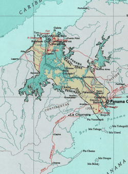
Map of the Panama Canal Zone.


Map of the area before canal construction


Abandoned theatre in Fort Davis (2011)
The Canal Zone was generally divided into two sections, the Pacific side and the Atlantic side, separated by Gatun Lake.
A partial list of Canal Zone townships and military installations:
Pacific side[]
Townships[]
- Ancón – built on the lower slopes of Ancon Hill, adjacent to Panama City. Also home to Gorgas Hospital.
- Balboa – the Zone's administrative capital, as well as location of the harbor and main Pacific-side high school.
- Balboa Heights
- Cardenas – as the Canal Zone was gradually handed over to Panamanian control, Cardenas was one of the last Zonian holdouts.
- Cocoli
- Corozal
- Curundu – on a military base, but housed civilian military workers
- Curundu Heights
- Diablo
- Diablo Heights
- Gamboa – headquarters of dredging division, located on Gatun Lake. Many new arrivals to the Canal Zone were assigned here.
- La Boca – home of the Panama Canal College.
- Los Rios
- Paraíso
- Pedro Miguel
- Red Tank – abandoned and allowed to be overgrown around 1950.
- Rosseau – built as a naval hospital during World War II, housed FAA personnel until Cardenas was built. Torn down after about 20 years.
Military installations[]
- Fort Amador – on the coast, partly built on land extended into the sea using excavation materials from the canal construction
- Fort Clayton – on the east side of the canal, it was the headquarters of the 193rd Infantry and the Southern Command Network, an American Forces Radio and Television Service outlet.
- Corozal Army Post – close to, but separate from, the civilian township.
- Fort Kobbe
- Rodman Marine Barracks
- Albrook Air Force Base
- Howard Air Force Base
- Quarry Heights – headquarters of the United States Southern Command.
Atlantic side[]
Townships[]
- Brazos Heights: privately owned housing (by United Brands and other, mostly shipping companies) where employees and owners of shipping agencies, lawyers, and the head of the YMCA lived.
- Coco Solo – main hospital and site of the only Atlantic-side high school, Cristobal High School.
- Cristóbal – main harbor and port.
- Gatún
- Margarita
- Mount Hope – site of the only Atlantic-side cemetery and drydock.
- Rainbow City
Military installations[]
- Fort Gulick – home to the School of the Americas.
- Galeta Island
- Fort Randolph – located on Margarita Island in Manzanillo Bay.
- Fort De Lesseps – located in Colón.
- Fort Davis
- France Field
- Fort Sherman – home to Jungle Operations Training Center.
Postage stamps[]


Two Canal Zone stamps showing precancels.
The Panama Canal Zone issued its own postage stamps from 1904 until October 25, 1978. After a transition period, Panama administered the stamps.
See also[]
References[]
- ↑ "Panama Canal". infoplease.com. http://www.infoplease.com/ce6/world/A0837445.html. Retrieved 2008-06-02.
- ↑ 2.0 2.1 Maurer and Yu, pp. 15–18.
- ↑ Major, p. 9.
- ↑ Major, pp. 10–11.
- ↑ Major, p. 11.
- ↑ Maurer and Yu, pp. 33–34.
- ↑ Maurer and Yu, pp. 35–36.
- ↑ Major, p. 13.
- ↑ Major, pp. 15–16.
- ↑ Major, pp. 18–24.
- ↑ Major, pp. 24–28.
- ↑ Maurer and Yu, p. 76.
- ↑ Maurer and Yu, pp. 78–82.
- ↑ Maurer and Yu, pp. 82–86.
- ↑ McCullough, pp. 397–399, 402.
- ↑ Rhonda D. Frederic (2005). "Colón Man a Come": Mythographies Of Panama Canal Migration". Lexington Books. p. 33. ISBN 0-7391-0891-3. http://books.google.com/?id=CSNTpYIB228C.
- ↑ Greene, p. 62.
- ↑ 18.0 18.1 Major, pp. 78–81.
- ↑ Greene, p. 63.
- ↑ 20.0 20.1 Maurer and Yu, p. 111.
- ↑ Maurer & Yu, pp. 111–112.
- ↑ Kaysha Lisbeth Corinealdi, “Redefining Home: West Indian Panamanians and Transnational Politics of Race, Citizenship, and Diaspora, 1928-1970” (PhD diss., Yale University, 2011), 43.
- ↑ Ibid, 44-45; “Canal Zone Workers Rally to CIO: Plan Program,” Chicago Defender, Aug. 31, 1946.
- ↑ Ibid, 47-48
- ↑ Michael Conniff, Black Labor on a White Island: Panama, 1904-1981 (Pittsburgh: University of Pittsburgh Press, 1985), 113.
- ↑ Frank Gurridy, Forging Diaspora: Afro-Cubans and African Americans (Chapel Hill: The University of North Carolina Press, 2010), 5.
- ↑ McCullough, pp. 478–79.
- ↑ Maurer and Wu, pp. 192–94.
- ↑ Maurer and Wu, pp. 194–96.
- ↑ Knapp and Knapp, pp. 183–84.
- ↑ United States Supreme Court, Downes v. Bidwell.
- ↑ "Not Part of United States" (PDF). The New York Times. July 29, 1904. http://query.nytimes.com/mem/archive-free/pdf?res=9C06E1DF113BE631A2575AC2A9619C946597D6CF. Retrieved 2008-06-02.|
- ↑ United States Supreme Court, [1].
- ↑ "Nationality" in: 7 FAM 1111.3 (c).
- ↑ 8 U.S.C. § 1403
- ↑ Cf. 8 U.S.C. § 1403, paragraph (a): "whether before or after the effective date of this chapter".
- ↑ Impomeni, Mark. Clinton, Obama Sponsor McCain Citizenship Bill. PoliticsDaily.com. May 2008. Retrieved 2012-09-04.
- ↑ "Earl Holmes Bell (1955–)". The Encyclopedia of Arkansas History & Culture. http://www.encyclopediaofarkansas.net/encyclopedia/entry-detail.aspx?search=1&entryID=3092. Retrieved June 5, 2013.
Further reading and viewing[]
- "More American than America". Jan 24, 1964. http://content.time.com/time/magazine/article/0,9171,875649,00.html.
- "PANAMA: No More Tomorrows". Oct 15, 1979. http://content.time.com/time/magazine/article/0,9171,916932-1,00.html.
- Greene, Julie (2009). The Canal Builders: Making America's Empire at the Panama Canal. New York: The Penguin Press. ISBN 978-1-59420-201-8.
- Harding, Robert C. (2001). Military Foundations of Panamanian Politics. Transaction Publishers. ISBN 978-0-7658-0075-6.
- Harding, Robert C. (2006). The History of Panama. Greenwood Publishing. ISBN 978-0-313-33322-4.
- Knapp, Herbert and Knapp, Mary (1984). Red, White and Blue Paradise: The American Canal Zone in Panama. San Diego: Harcourt, Brace, and Jovanovich. ISBN 0-15-176135-3.
- Major, John (1993). Prize Possession: The United States and the Panama Canal, 1903–1979. Cambridge: Cambridge University Press. ISBN 978-0-521-52126-0.
- Maurer, Noel and Yu, Carlos (2011). The Big Ditch: How America Took, Built, Ran, and Ultimately Gave Away the Panama Canal. Princeton, New Jersey: Princeton University Press. ISBN 978-0-691-14738-3.
- McCullough, David (1977). The Path Between the Seas: The Creation of the Panama Canal, 1870–1914. New York: Simon and Schuster. ISBN 978-0-671-24409-5.
- Mellander, Gustavo A. (1971) The United States in Panamanian Politics:The Intriguing Formative Years. Danville, Ill.: Interstate Publishers, OCLC 138568
- Mellander, Gustavo A.; Nelly Maldonado Mellander (1999). Charles Edward Magoon: The Panama Years. Río Piedras, Puerto Rico: Editorial Plaza Mayor. ISBN 1-56328-155-4. OCLC 42970390.
- "Canal Zone". Zipporah Films. 1977. http://www.zipporah.com/films/31.
External links[]
| Wikimedia Commons has media related to Panama Canal Zone. |
- Lots of Panama Canal info, including data on military bases
- Governor Parfitt's Address at Flag-lowering Ceremonies September 30, 1979
- Maps of the Canal Zone
- Live Panama Canal webcams
- Air Defense of the Panama Canal 1958–1970
- Panama & the Canal Digital Collection
- Medicine in the Panama Canal Zone: The Samuel Taylor Darling Memorial Library Archives
The original article can be found at Panama Canal Zone and the edit history here.