
The Penobscot Expedition was an American naval expedition sent to reclaim Maine, which the British had conquered and renamed New Ireland. It was the largest American naval expedition of the American Revolutionary War and is the United States' worst naval defeat until Pearl Harbor.[6] The fighting took place both on land and on sea, in what is today Castine, Maine. The defeat of the Expedition was one of the greatest British victories of the war.
In June 1779, British Army forces under the command of British General Francis McLean established a series of fortifications centered on the British fort, Fort George, located on the Majabigwaduce Peninsula in Penobscot Bay, with the goals of establishing a military presence on that part of the coast and beginning a new colony to be known as New Ireland. In response, the state of Massachusetts, with some support from the Continental Congress, raised an expedition to drive the British out.
The Americans landed troops in late July and attempted to establish a siege of the Fort George in a series of actions seriously hampered by disagreements over control of the expedition between Commodore Dudley Saltonstall and General Solomon Lovell. For two weeks British General Francis McLean held off the assault until a British fleet under the command of Sir George Collier arrived on August 13, driving the American fleet to total self-destruction up the Penobscot River. The survivors of the American expedition were forced to make an overland journey back to more-populated parts of Massachusetts with minimal food and armament.
Background[]
Following partially successful raid of Machias in 1777, as well as General John Burgoyne's failed Saratoga campaign, British war planners looked for other ways to gain control over the rebellious New England colonies, while most of their effort was directed at another campaign targeted at the southern colonies. Lord Germain, the Secretary of State responsible for the war effort, and his under-secretary, William Knox, wanted to establish a base on the coast of the District of Maine (which was then a part of Massachusetts) that could be used to protect Nova Scotia's shipping and communities from American privateers and raiders.[7]
Opportunity arrived when John Nutting, a Loyalist who had piloted Sir George Collier's expedition against Machias, came to London with the idea of establishing a British military presence in Maine. In September 1778, Nutting left for New York carrying orders for Lieutenant General Sir Henry Clinton to assist with the establishment of "a province between the Penobscot and St. Croix rivers. Post to be taken on Penobscot River."[8] It was Knox's idea to call this province New Ireland.[6] Unfortunately for the British, Nutting's ship was captured by an American privateer, and he was forced to dump his dispatches, putting an end to execution of the idea in 1778.[8]
British forces arrive[]
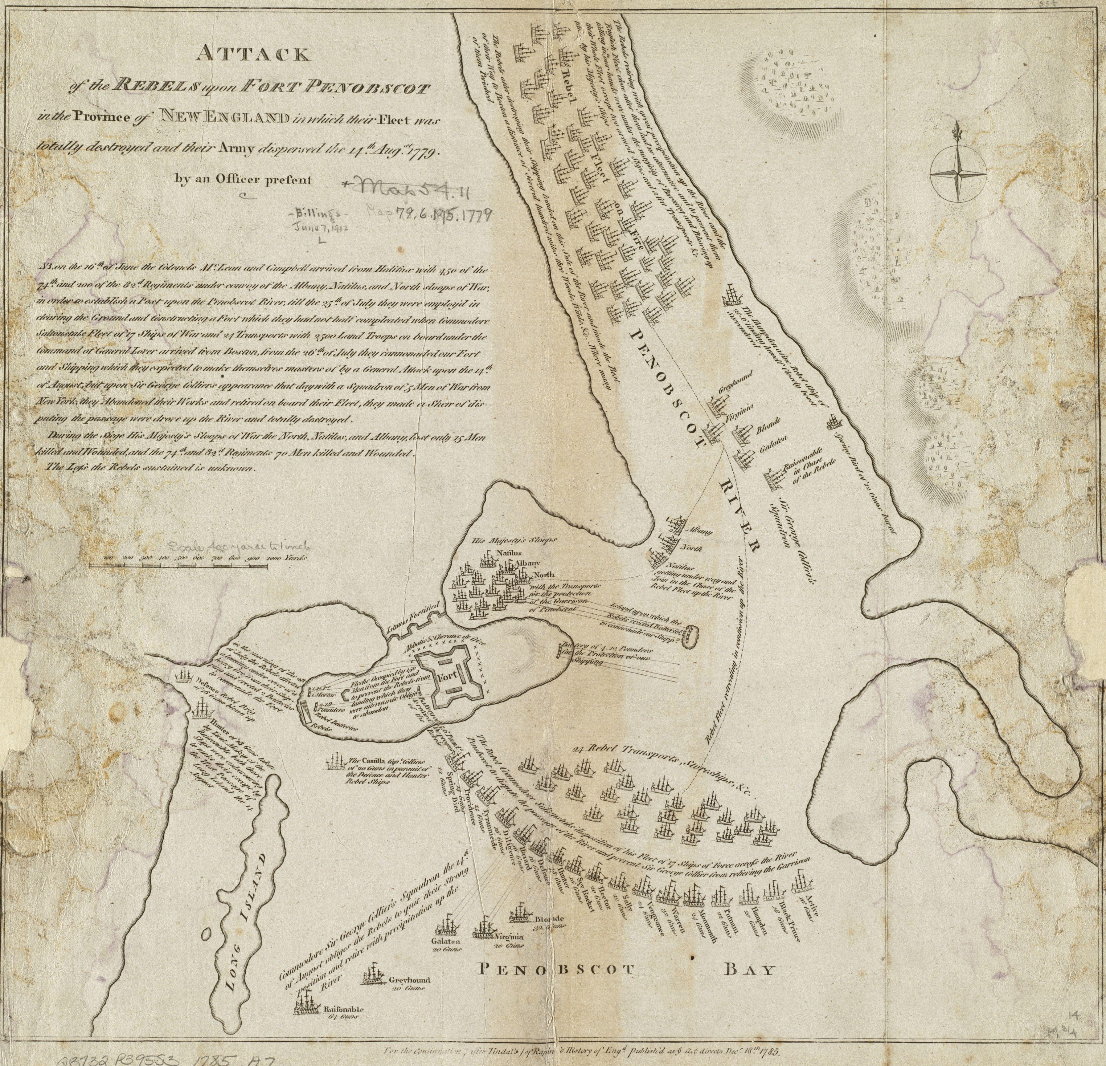

A 1785 map depicting this action. The map is in mirror image (the Penobscot River is actually west of the Majabigwaduce peninsula, where the fort is located) and not to scale.
Nutting reached New York in January 1779, but General Clinton had received copies of the orders from other messengers. Clinton had already assigned the expedition to General Francis McLean, who was based in Halifax, so he sent Nutting there with Germain's detailed instructions.[9]
McLean's expedition set sail from Halifax on May 30, 1779, and arrived in Penobscot Bay on June 12. The next day McLean and Andrew Barkley, the captain of the naval convoy, identified a suitable site at which they could establish a post.[10] On June 16, his forces began landing on a peninsula that was then called Majabigwaduce (now Castine), between the mouth of the Bagaduce River and a finger of the bay leading to the Penobscot River.[6] The troops numbered approximately 700: 50 men of the Royal Artillery and engineers, 450 of the 74th Regiment of (Highland) Foot and 200 of the 82nd (Duke of Hamilton's) Regiment.[1] These began to build a fortification on the peninsula, which jutted into the bay and commanded the principal passage into the inner harbor.
The principal works, called Fort George, was in the center of the small peninsula, with two batteries outside the fort to provide cover for the Albany, which was the only ship expected to stay in the area. A third battery was constructed on an island south of the bay in which Albany was harbored, near the mouth of the Bagaduce River. Construction of the works occupied the troops for the next month, until rumors came that an American expedition was being raised to oppose them,[11] following which efforts were redoubled to have works suitable for defense against the Americans prepared before they arrived.[12] Albany's captain, Henry Mowat, who was familiar with Massachusetts politics, took the rumors (which were followed by reports that a fleet had left Boston) quite seriously, and convinced General McLean to leave additional ships that had been part of the initial convoy as further defense. Some of the convoy ships had already left; orders for armed sloops North and Nautilus were countermanded before they were able to leave.[13]
American reaction[]


Francis McLean Plaque, St. Paul's Church (Halifax), Nova Scotia
When news of this reached the American authorities in Boston, they hurriedly made plans to drive the British from the area. The Penobscot River was the gateway to lands controlled by the Penobscot Indians, who generally favored the British. Congress feared that if a fort were successfully constructed at the mouth of the river, all chance of enlisting the Penobscots as allies would be lost. Massachusetts was also motivated by the fear of losing their claim over the territory to rival states in any post-war settlement.[14]
To spearhead the expedition, Massachusetts petitioned Congress for the use of three Continental Navy warships—the 12-gun sloop Providence, 14-gun brig Diligent, and 32-gun frigate Warren—while the rest of over 40 ships were made up of ships of the Massachusetts State Navy and private vessels under the command of Commodore Dudley Saltonstall. The Massachusetts authorities mobilized more than 1,000 militia, acquired six small field cannons, and placed Brigadier General Solomon Lovell in command of the land forces. The expedition departed from Boston on July 24 and arrived off Penobscot Bay that same day.
Landing[]
On July 25, nine of the larger vessels in the American flotilla exchanged fire with the Royal Navy ships from 3.30 p.m to 7.00 p.m. While this was going on, seven American boats approached the shore for a landing but turned back when enemy fire killed an American-allied Native warrior in one of the boats.[15] On July 26, Lovell sent a force of Continental Marines to capture the British battery on Nautilus Island (also known as Banks Island),[16] while the militia were to land at Bagaduce. The marines achieved their objective but the militia turned back when British shot overturned the leading boat, drowning Major Daniel Littlefield and two of his men.[17] Meanwhile, 750 men under Lovell landed and began construction of siege works under constant fire. On July 27, the American artillery bombarded the British fleet for three hours, wounding four men aboard HMS Albany.[18]
Assault[]
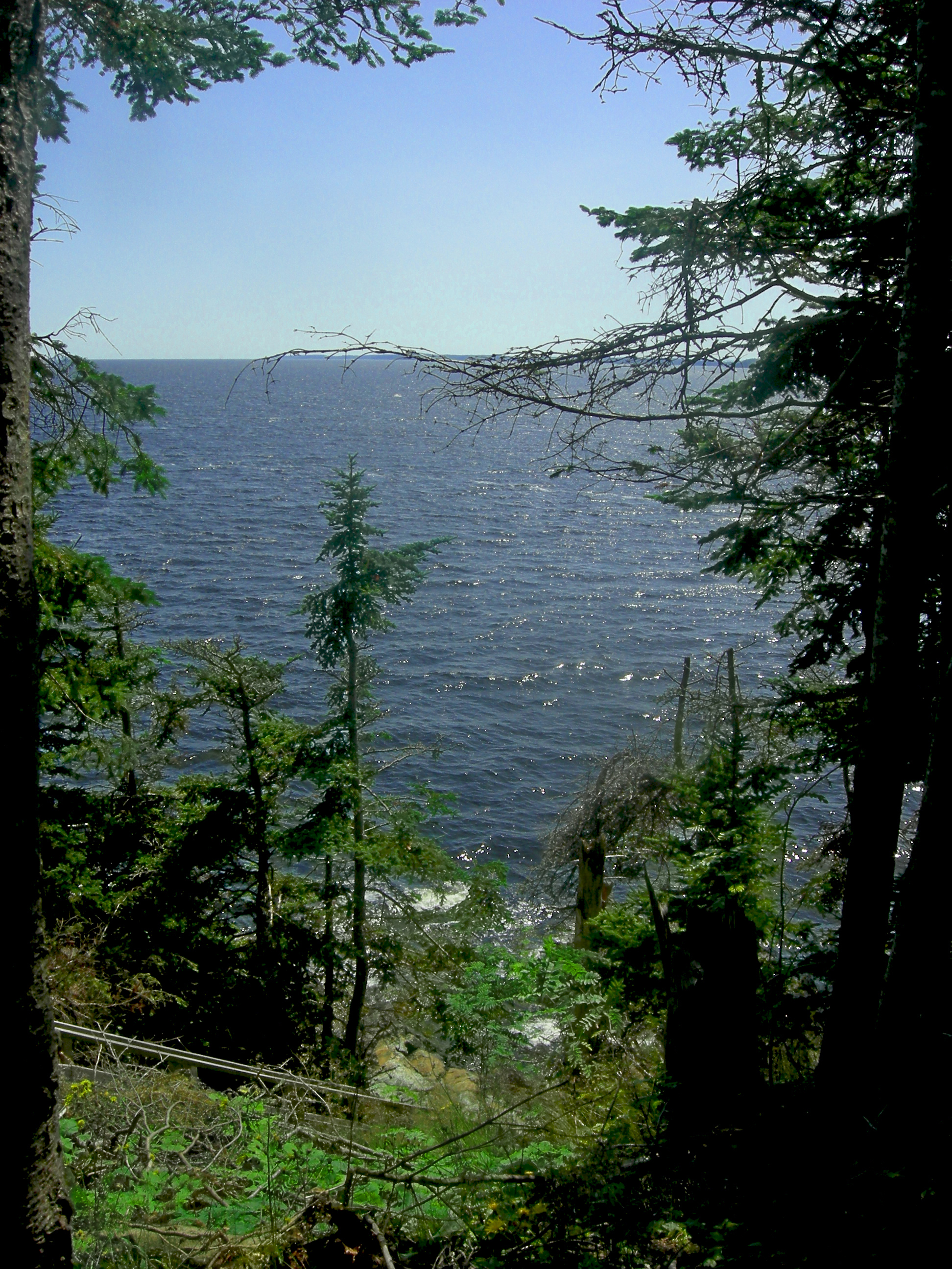

The Penobscot Bay seen from Dyce's Head, the site of the American's pre-dawn landing on July 28, 1779
On July 28, under heavy covering fire from the Tyrannicide, the Hunter and the Sky Rocket, Brigadier General Peleg Wadsworth led an assault force of 400 (200 marines and 200 militia)[19] ashore before dawn at Dyce's Head on the western tip of the peninsula with orders to capture the British fort. They landed on the narrrow beach and advanced up the steep bluff leading to the fort. The British pickets, who included Lieutenant John Moore, put up a determined resistance but received no reinforcement from the fort and were forced to retire, leaving the Americans in possession of the heights. Eight British troops were captured.[4] At this point, Lovell ordered the attackers to halt and entrench where they were. Instead of assaulting the fort, Lovell had decided to build a battery within "a hundred rods" of the British lines and bombard them into surrender.[20] The American casualties in the assault had been severe: "one hundred out of four hundred men on the shore and bank",[21] with the Continental Marines suffering more heavily than the militia. Commodore Saltonstall was so appalled by the losses incurred by his marines that he refused to land any more and even threatened to recall those already on shore.[19]
Siege[]

Sir John Moore served at Halifax (1779-1781) and protected New Ireland from American patriot Penobscot Expedition
.
On July 29, 1 American was killed.[22] On July 30, both sides cannonaded each other all day.[23] On July 31, 2 American sailors belonging to the Active were wounded by a shell.[22] On August 1, Lovell ordered a night assault on the Half-Moon Battery, next to Fort George, whose guns posed a danger to the American shipping. The Americans opened fire at 2.00 a.m. Colonel Samuel McCobb's center column, comprising his own Lincoln County Regiment, broke and fled as soon as the British returned fire. The left column comprising Captain Thomas Carnes and a detachment of marines, and the right column comprising sailors from the fleet, both kept going and stormed the Battery. As dawn broke, the Fort’s guns opened up on the captured battery and a detachment of redcoats charged out and recaptured the Half-Moon, routing the Americans, who took 18 prisoners with them. Their own casualties were 4 men missing (who were killed) and 12 wounded.[24] The siege continued with minor skirmishing. On August 2, militiaman Wheeler Riggs, of Falmouth, was killed by an enemy cannon shot that bounced off a tree before hitting him.[22] On August 4, Surgeon John Calef recorded in his journal that several men were wounded in exchanges of fire.[25] On August 5, one American-allied Indian was killed and another man captured.[22] On August 7, 100 Americans engaged 80 British but the only casualties were 1 killed and 1 wounded on the American side and 2 wounded among the British.[26]


British Commander George Collier - destroyed the American Fleet
During this time, the British had been able to send word of their condition, and request reinforcements. On August 3, British commander George Collier led a fleet of 10 warships out of New York.[27]
On August 11, about 250 American militia advanced from their fortified camp and occupied a recently abandoned battery about a quarter mile (400 meters) from the British fort. As expected, a sortie of about 55 British troops advanced from the fort to engage: but the poorly trained American troops fired only one volley at the attacking British troops, inflicting about 13 casualties, and fled back to their fort, leaving behind all of their arms and equipment.
The next day, Saltonstall finally decided to launch a naval attack against the British fort, but Collier in command of the British relief fleet arrived and attacked the American ships.[28] Over the next two days, the American fleet fled upstream on the Penobscot River, pursued by the Collier. On August 13, an American officer was wounded by enemy fire.[22] Several vessels were scuttled or burned along the way with the rest destroyed at Bangor. In the 18th century there were rapids at Bangor at the approximate location of the old Water Works. The surviving crews then fled overland back to Boston with virtually no food or ammunition.
Casualties[]
Over the course of the siege, Colonel David Stewart claims the British garrison suffered 25 killed and 34 wounded.[3] Stewart gives no figures for captured or missing but 26 prisoners are known to have been taken by the Americans.[4] Apart from the 100 men killed and wounded during the assault of July 28, the known American casualties throughout the siege came to 12 killed, 16 wounded and 1 captured, in addition to "several wounded" on August 4. This adds up to at least 130 killed and wounded. The History of Penobscot says that "our whole loss of men was probably not less than 150".[29] The chaotic retreat however, brought the American loss up to 474 killed, wounded, captured or missing.[5]
Aftermath[]
A committee of inquiry blamed the American failure on poor coordination between land and sea forces and on Commodore Saltonstall's failure to engage the British naval forces. Saltonstall was declared to be primarily responsible for the debacle, and he was court-martialed, found guilty, and dismissed from military service. Paul Revere, who commanded the artillery in the expedition, was accused of disobedience and cowardice. This resulted in his dismissal from the militia, even though he was later cleared of the charges. Peleg Wadsworth, who mitigated the damage by organizing a retreat, was not charged in the court martial.
The British evacuated the area pursuant to the terms of the 1783 Peace of Paris, abandoning their attempts to establish New Ireland. During the War of 1812 the British again occupied the area they called New Ireland, and used it as a naval base before withdrawing again with the arrival of peace. Full ownership of present-day Maine (principally the northeastern borders with New Brunswick) remained disputed until the Webster-Ashburton Treaty in 1842. Maine was a part of Massachusetts until 1820, when it was admitted into the Union as the 23rd state.
Legacy[]
In 1972 the Maine Maritime Academy and the Massachusetts Institute of Technology searched for and found the wreck of the Defence, a privateer that was part of the American fleet.[30] Evidence of scuttled ships has also found under the Joshua Chamberlain Bridge in Bangor and under the Bangor town dock, and several artifacts were recovered. Cannonballs were also reported to have been recovered during the construction of the concrete casements for the I-395 bridge in 1986.
The earthworks of Fort George still stand at the mouth of the Penobscot River in Castine, accompanied by concrete work added later by the Americans in the 19th century. Archaeological evidence of the expedition, including cannonballs and cannon, was located during an archaeological project in 2000–2001.
See also[]
References[]
- ↑ 1.0 1.1 Buker, p. 11
- ↑ 2.0 2.1 2.2 Campbell, p. 498
- ↑ 3.0 3.1 Stewart, p. 115
- ↑ 4.0 4.1 4.2 Buker, p. 176, note 67
- ↑ 5.0 5.1 Boatner, p. 852
- ↑ 6.0 6.1 6.2 Bicheno, p.149
- ↑ Buker, pp. 4–5
- ↑ 8.0 8.1 Buker, p. 5
- ↑ Buker, p. 6
- ↑ Buker, p. 7
- ↑ Buker, p. 13
- ↑ Buker, p. 15
- ↑ Buker, p. 14
- ↑ Bicheno, pp. 149–150
- ↑ Buker, p. 37
- ↑ A Naval History of the American Revolution: Chapter XII, The Penoboscot Expedition, http://www.americanrevolution.org/navy/nav12.html
- ↑ Buker, pp. 36,39–40
- ↑ Buker, p. 41
- ↑ 19.0 19.1 Goold, quoting General Wadsworth
- ↑ Buker, pp. 42–45
- ↑ Williams and Chase, p. 89, quoting William D. Williamson's History of Maine. Williamson got this casualty information directly from General Wadsworth
- ↑ 22.0 22.1 22.2 22.3 22.4 Goold, quoting William Moody’s Journal
- ↑ Buker, p. 49
- ↑ Buker, pp. 50–52
- ↑ Buker, p. 56
- ↑ Buker, p. 66
- ↑ Campbell, p. 497
- ↑ Bicheno, p. 152
- ↑ Williams and Chase, p. 90
- ↑ http://ina.tamu.edu/defence/defence.htm
Sources[]
- Bicheno, Hugh (2003). Redcoats and Rebels: The American Revolutionary War. London: Harper Collins. ISBN 978-0-00-715625-2. OCLC 51963515.
- Boatner, Mark Mayo (1966). Cassell's Biographical Dictionary of the American War of Independence, 1763-1783. London: Cassell & Company. ISBN 0-304-29296-6.
- Buker, George E (2002). The Penobscot Expedition: Commodore Saltonstall and the Massachusetts Conspiracy of 1779. Annapolis, Maryland: Naval Institute Press. ISBN 1-55750-212-9. OCLC 47869426.
- Campbell, John; Berkenhout, John, and Yorke, Henry Redhead (1813). Lives of the British Admirals: Containing Also a New and Accurate Naval History, from the Earliest Periods, volume 5. London: C. J. Barrington. OCLC 17689863. http://books.google.com/books?id=XQcSAAAAYAAJ.
- Bagaduce Expedition, 1779: Collections of the Maine Historical Society, Second Series. Vol.10, 1899
- Hunter III, James W (2003). "Penobscot Expedition Archaeological Project Field Report" (PDF). Naval Historical Center. https://www.denix.osd.mil/portal/page/portal/content/environment/CR/ArchaeologicalResources/UnderwaterArchaeology/Penobscot_Report.pdf. Retrieved 2009-04-08.
- Stewart, David (1977 (first published, 1822)). Sketches of the Character, Manners, and Present State of the Highlanders of Scotland; with Details of the Military Service of the Highland Regiments. Volume II. Edinburgh: John Donald Publishers.
- Wheeler, George A (1875). History of Castine: Battle Line of Four Nations. Bangor, Maine: Burr & Robinson. OCLC 2003716. http://books.google.com/books?id=HReiMAr8lf4C.
- Williams and Chase (1882). History of Penobscot, Maine, with Illustrations and Biographical Sketches. Cleveland, OH: Williams, Chase & Co..
Further reading[]
- Bernard Cornwell, The Fort, HarperCollins, 2010. An historical novel depicting the Penobscot Expedition, with a non-fiction "Historical Note" (pp. 451–468) on sources and key details.
- Thesis - Penobscot Expedition
External links[]
- Revolutionary War-Era Swivel Gun reveals its secrets (about a gun raised from Penobscot Bay)
- "The Ancient Penobscot, or Panawanskek." Historical Magazine, February, 1872.
- A Short History of the Penobscot Expedition
Coordinates: 44°23′28″N 68°48′20″W / 44.391°N 68.8056°W
The original article can be found at Penobscot Expedition and the edit history here.