| RAF Henley-on-Thames | |||
|---|---|---|---|
| IATA: none – ICAO: none | |||
| Summary | |||
| Airport type | Military | ||
| Owner | Air Ministry | ||
| Operator | Royal Air Force | ||
| Location | Henley-on-Thames, Berkshire | ||
| Built | 1939 | ||
| In use | 1940-1945 | ||
| Coordinates | 51°32′05″N 000°51′18″W / 51.53472°N 0.855°WCoordinates: 51°32′05″N 000°51′18″W / 51.53472°N 0.855°W | ||
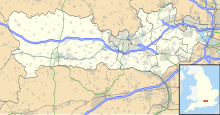
| Map | |||
| Location in Berkshire | |||
| Runways | |||
| Direction | Length | Surface | |
| ft | m | ||
| 00/00 | 0 | 0 | Grass |
| 00/00 | 0 | 0 | Grass |
RAF Henley-on-Thames is a former Royal Air Force grass-strip airfield in Berkshire, England, located near Henley-on-Thames. It was also known by a variety of other names: Cockpole Green, Upper Culham Farm, Crazies Hill, or Crazies Hill Farm.[citation needed]
History
The site was used to assemble and test Supermarine Spitfires and as a Relief Landing Ground for RAF White Waltham and RAF Woodley. It was built in late 1939 and closed in October 1945.[1]
Current use
There is currently little to see on satellite imagery that the airfield existed as the runways were grass.
See also
References
External links
| ||||||||||||||||||||||||||||||||
The original article can be found at RAF Henley-on-Thames and the edit history here.

