| Santo-Pekoa International Airport | |||
|---|---|---|---|
| IATA: SON – ICAO: NVSS | |||
| Summary | |||
| Operator | Airports Vanuatu Limited | ||
| Location | Luganville, Vanuatu | ||
| Elevation AMSL | 184 ft / 56 m | ||
| Coordinates | 15°30′21″S 167°13′17″E / 15.50583°S 167.22139°ECoordinates: 15°30′21″S 167°13′17″E / 15.50583°S 167.22139°E | ||
| Map | |||
 SON | |||
| Runways | |||
| Direction | Length | Surface | |
| ft | m | ||
| 12/30 | 6,523 | 1,988 | Asphalt |
| Sources: World Aero Data,[1] Great Circle Mapper [2] | |||
| Pekoa Airfield | |
|---|---|
| Espiritu Santo, New Hebrides Islands | |
| Coordinates | 15°30′18.12″S 167°13′11.07″E / 15.5050333°S 167.2197417°E |
| Type | Military Airfield |
| Site information | |
| Controlled by |
United States Army Air Forces United States Navy |
| Condition | abandoned |
| Site history | |
| Built | 1942 |
| Built by | Seebees |
| In use | 1942-5 |
| Materials | Coral |
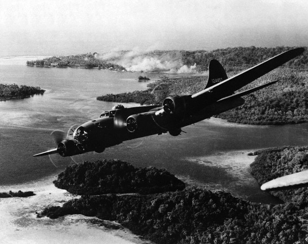
Boeing B-17F 41-24457 (Aztec's Curse), 11th Bomb Group, 31st Bombardment Squadron from Pekoa Airfield, Espiritu Santo, flying over Rendova, Solomon Islands 5 October 1942 after a raid of Japanese-held positions on Gizo Island.
Santo-Pekoa International Airport is an airport in Luganville on Espiritu Santo in Vanuatu (IATA: SON, ICAO: NVSS). Airports Vanuatu Limited provides aviation services for the airport.
Airlines and destinations[]
| Airlines | Destinations |
|---|---|
| Air Vanuatu | Brisbane,[3] Gaua, Longana, Lonorore, Norsup, Olpoi, Port Vila, Sola, Walaha |
History[]
World War II[]
The 7th Naval Construction Battalion arrived on Santo on 11 August 1942 and began construction of more extensive air facilities to support the Guadalcanal Campaign. After completing a second fighter airfield at Turtle Bay they began constructing two bomber fields, one at Palikulo Bay known as Bomber Field No. 1 and the other at Pekoa, known as Bomber Field No. 2. Working in cooperation with a company of the US Army 810th Engineer Aviation Battalion, the 7th Battalion cleared, graded, and surfaced a 5,000 feet (1,500 m) by 150 feet (46 m) coral runway on the site of a prewar plantation. The 15th Naval Construction Battalion arrived on Santo on 13 October 1942 and extended the runway to 7,000 feet (2,100 m) with PSP over a coral base, and built taxiways, revetments, and miscellaneous structures.[4] The completed airfield was operational in December 1942 and was known as "Bomber Field No. 2" or "Pekoa Field".
The Thirteenth Air Force was based at Pekoa from 13 January 1943 until 20 January 1944 when it moved to Carney Airfield on Guadalcanal. Units assigned were:
- Headquarters, XIII Bomber Command, 13 January-20 August 1943
- Headquarters, XIII Fighter Command, 22 January–December 1943
- 5th Bombardment Group, 1 December 1942 – 19 August 1943
- 11th Bombardment Group, 22 July 1942 – 8 April 1943
- 18th Fighter Group, 11 March-17 April 1943
- 4th Reconnaissance Group, 23 January 1943 – 6 May 1944
- 403d Troop Carrier Group, 13 September 1943 – 30 August 1944
As the war moved further north, Pekoa Airfield was closed on 8 February 1945 and all traffic routed to Palikulo Bay Airfield.
Postwar[]
Luganville Airfield was used as a civilian airstrip until the early 1970s, however as it was on higher ground it was often clouded in and so it was decided to move all operations to the former Pekoa Airfield/Bomber Field No.2 which became Santo-Pekoa International Airport.[5]
Of the four wartime airfields on Espiritu Santo: Turtle Bay Airfield, Palikulo Bay Airfield, Luganville Airfield and Pekoa, Pekoa is the only wartime airfield still in use.
See also[]
- Luganville Airfield
- Luganville Seaplane Base
- Palikulo Bay Airfield
- Turtle Bay Airfield
- USAAF in the South Pacific
References[]
![]() This article incorporates public domain material from the Air Force Historical Research Agency website http://www.afhra.af.mil/.
This article incorporates public domain material from the Air Force Historical Research Agency website http://www.afhra.af.mil/.
- Maurer, Maurer (1983). Air Force Combat Units Of World War II. Maxwell AFB, Alabama: Office of Air Force History. ISBN 0-89201-092-4.
- Maurer, Maurer, ed (1982) [1969]. Combat Squadrons of the Air Force, World War II (reprint ed.). Washington, DC: Office of Air Force History. ISBN 0-405-12194-6. LCCN 70605402. OCLC 72556. http://www.airforcehistory.hq.af.mil/Publications/fulltext/combat_sq_of_the_af_wwii.pdf.
- ↑ http://worldaerodata.com/wad.cgi?id=NH96641
- ↑ Airport information for Luganville, Espiritu Santo, Vanuatu (NVSS / SON) at Great Circle Mapper.
- ↑ Air Vanuatu - International Flight Information
- ↑ Building the Navy's Bases in World War II History of the Bureau of Yards and Docks and the Civil Engineer Corps 1940-1946. US Government Printing Office. 1947. p. 228.
- ↑ Stone, Peter (1997). The Lady and the President: The life and loss of the S.S. President Coolidge. Oceans Enterprises. p. 65. ISBN 9780958665728.
External links[]
The original article can be found at Santo-Pekoa International Airport and the edit history here.