| Slavonian Military Frontier Slawonische Militärgrenze Slavonska vojna granica Славонска војна граница Slavonska vojna krajina Славонска војна крајина | |
|---|---|
| section of the Military Frontier, Habsburg Monarchy | |
| 18th century–1882 | |
 Slavonian Krajina in 1751 | |
| History | |
| History | |
• Established | 18th century |
• Disestablished | 1882 |
| Today part of | Croatia, Serbia |
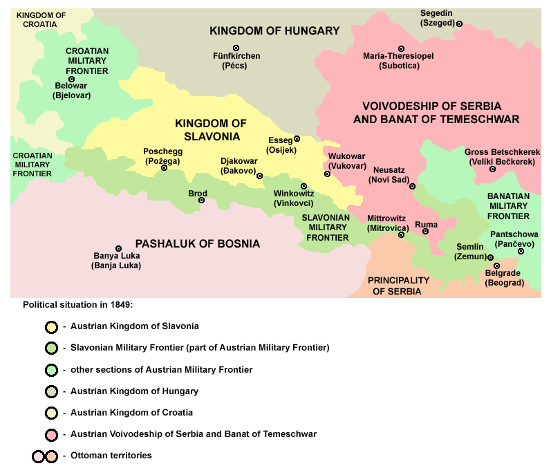
Slavonian Krajina in 1849
The Slavonian Military Frontier or Slavonian Krajina was part of the Habsburg Military Frontier. It was formed out of territories the Habsburgs conquered from the Ottoman Empire and included southern parts of Slavonia and Syrmia; today the area it covered is mostly in eastern Croatia, with its easternmost parts in northern Serbia (mostly in Vojvodina region).
Divisions[]
The Slavonian Krajina was divided between three regiments, named after towns in the area: Gradiška, Brod, and Petrovaradin; however, the regimental seat of the Brod regiment was in Vinkovci. Other important towns in the area included Sremski Karlovci, Stara Pazova, Zemun, and Sremska Mitrovica.
History[]
During the history, name Slavonian Krajina referred to different territories. Original Slavonian Krajina was located in what is now Central Croatia and was known as the Varaždin generalat. It was created from territories that formerly were part of medieval Banovina of Slavonia. Shortly after its creation in the 16th century, original Slavonian Krajina bordered the Ottoman Empire to the east, the Habsburg Kingdom of Croatia (part of the Habsburg Empire) to the west, the Croatian Krajina to the south-west, and the Habsburg Kingdom of Hungary, also part of the Habsburg Empire, to the north. After the Treaty of Karlowitz (1699), Habsburg Monarchy expanded its territory towards east and new sections of the Military Frontier were founded along the Sava, Danube, Tisa and Mureş rivers. New parts of the frontier were divided into two generalats: the first one included territory from Gradiška to river Tisa and the second one included territories along the Tisa and Mureş rivers. Until the middle of the 18th century, the entire Slavonia region was under military administration. In 1745, northern parts of Slavonia were placed under civil administration and were organized into the newly formed Habsburg crownland known as the Kingdom of Slavonia. The southern parts of Slavonia that remained under military administration were organized into Slavonian Military Frontier or Slavonian Krajina, while former original Slavonian Krajina was organized as Varaždin section of the Croatian Military Frontier.
In the second half of the 18th century, the Slavonian Krajina bordered the Habsburg Kingdom of Croatia and the Croatian Military Frontier to the west, the Habsburg Kingdom of Slavonia and the Habsburg Kingdom of Hungary to the north, the Banat Military Frontier to the east and the Ottoman province of Bosnia and Sanjak of Smederevo to the south. The only changes of this province's borders and neighborhood before its integration into Croatia-Slavonia in 1882 were in 1848–1849 when autonomous Serbian Vojvodina included eastern parts of Slavonian Krajina and between 1849 and 1860, during the existence of Voivodeship of Serbia and Banat of Temeschwar, a separate Habsburg crownland which became an north-eastern neighbor of Slavonian Krajina. After the creation of the Principality of Serbia in 1815, this was the Slavonian Krajina's southeastern neighbor.
Population and Demographics[]
1776[]
In 1776, the rural population of the Slavonian military frontier was 177,212. The number of Roman Catholic men was 43,635, while number of Orthodox men was 33,970. The number of inhabitants of cities was 11,353, and that giving a total of 188,565 inhabitants.
In Brod and Gradiška regiments Catholics outnumbered the minority Orthodox, and in Petrovaradin regiment the Orthodox were more numerous.
1820[]
In 1820, population of Slavonian Krajina included 117,933 Catholics and 117,274 Orthodox Christians.[1]
1870[]
In 1870, Slavonian military frontier had, according to official census, 246,901 inhabitants. Of that number 143,873 were Roman Catholic and 92,991 were Orthodox (living mainly in eastern Syrmia). Brod regiment had 82,540 inhabitants out of which 73,892 were Roman Catholic and 6,886 were Orthodox. Gradiška regiment had 61,596 inhabitants out of which 45,601 were Roman Catholic and 15,933 were Orthodox. Petrovaradin regiment had 102,765 inhabitants out of which 70,172 were Orthodox and 24,380 were Roman Catholic.
Sources[]
- Mladen Lorković, Narod i zemlja Hrvata, reprint, Split, 2005.
See also[]
- The Brod Fortress
References[]
- ↑ Dr Tomislav Bogavac, Nestajanje Srba, Niš, 1994, page 196.
External links[]
The original article can be found at Slavonian Military Frontier and the edit history here.