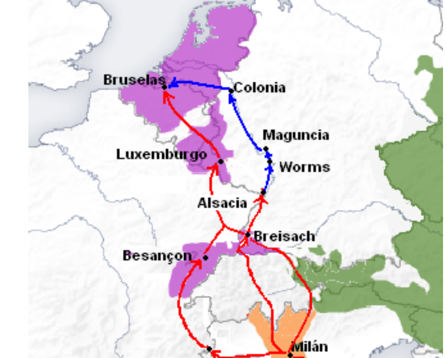
Spanish Road: Spanish possessions in orange and purple, Austria in Green. Main road in red, along the Rhine also in blue.
The "Spanish Road" was a military supply/trade route used from 1567–1620, which stretched from Northern Italy to the Low Countries. It crossed through relatively neutral territory, and was therefore Europe's most preferred military route. In the days of its use it was known in French as "le chemin des Espagnols".[1]
Soldiers were able to march the 1,000 km (620 mi) from Milan to Flanders an average of 23 km (14 mi) a day. Sea transport was much faster, able to cover about 200 kilometers (120 mi) a day, but was highly exposed to storms and enemy attacks. For large groups, overland communication was more reliable, allowing the Spanish to send over 123,000 men compared to only 17,600 by sea, between 1567 and 1620.[2]
Necessity[]
The conflict between the Spanish King Philip II and the Dutch rebels in the Spanish-ruled Habsburg Netherlands, culminating in the Eighty Years' War, symbolized the prominent European power struggle of the 16th century between Catholics and Protestants.[3] In 1550, the wars had stretched Spain's finances thin.[4] 1566 was known as the "Year of Hunger" or "Year of Wonders". When social, political and religious unrest culminated in the Compromise of Nobles and the Beeldenstorm, apparently endangering the government of Philip's Regent in Brussels, Margaret of Parma, Spanish troops under the Duke of Alba were dispatched to restore order and punish the perceived insurrectionists.[5] Those troops could at the time not be transported by sea and Philip was therefore forced to find a route to move troops from his garrisons in Spanish Italy overland to his Netherlands domains, crossing neutral territory.[6] The Spanish Road was surveyed and mapped out in 1566, and Alba used it in July 1567.[7]
Establishment[]
To get to the Netherlands, the armies and travellers of the 16th century had to overcome many obstacles including extremely high mountain passes, large rivers, deep forests, and roadways filled with criminals. Therefore, it was necessary to find a route that would go around these barriers, for safer and easier travel, and the Spanish Road proved to be the answer. Parts of the road were already in use, but it was Philip II of Spain in 1565, who brought it together when he decided to link up his separate territories through a route that travelled through them and neutral territory. Merchants came to regularly use parts of the road between France and Italy to trade goods with neighboring countries. The main territories it linked were Franche-Comté, Luxembourg, and the territories of allies, Lorraine and Savoy.[1]
The layout of the Spanish Road was a large improvement over the previous system of moving troops through neutral territory. Maps used for Spanish expeditions had only the information that pertained directly to the military, excluding any other details. However, this forced the armies to use guides and scouts when they crossed unfamiliar terrain, since their extremely generalized maps could not guide them.[1] Travelling along the road took an average of 12 miles a day, although, in 1577 Spanish veterans left the Netherlands and marched 15 miles a day because of the heat, and in 1578, they made the trip at the rate of 23 miles a day during the cold month of February.[1]
Utilization[]
For military purposes, the Spanish Road was first used by the Duke of Alba in 1567, and the last army passed through it in 1620. It was not only utilized by troops, but also traders, and both were in need of food and shelter to complete their journeys. Shelter was rarely given to those who traveled on the road, especially soldiers. Officers would sometimes be able to stay in a nearby town, but their armies had to sleep under bushes or flimsy huts that they would make themselves. Residents of towns along the "road" were rightfully fearful of the armies that passed through because they would often find themselves victims of a robbery if they offered up their generosity. In 1580, the officers of the passing Spanish tercios occupied a house in Franche-Comté that had no furniture and temporary crockery that was guarded, because the providers were scared their possessions would be vandalized, burned or stolen.[1]
The Spanish Road was only used once or twice per year by the military, and the rest of the time by merchants. Because of this, military magazines were seen as unimportant by some countries.[1] The military did, however, use a system of providing staples called etapés. This system was going to be put into place after the successful proposal of Don Cristóbal de Benavente to the Council of War in Madrid. Unfortunately, the Spanish King was not impressed, so Madrid did not support them. However, some "governors" did think the etapés were a good idea, so they set them up along the Spanish Road, using commissioners sent by the governor of the Low Countries or by the governor of the Milan to work out pricing details, so that the providers were always paid for their services. The first type of etapés was permanent and found only in Savoy. It consisted of a place where soldiers and other travelers had access to food and shelter when they passed through. The second type was in Franche-Comté, Lorraine and the Low Countries, and was created only when arranged for in advance by a private contractor, who would work out the payments, shipments and quantities of food based on the type and schedule of each individual military excursion.[1] This system made the use of the Spanish Road more practical.
Effects[]
Along with the Spanish Road's military function it also became an important commercial route. The road also helped the Spanish establish permanent diplomatic contacts along its route, such as permanent embassies in Savoy and the Swiss Cantons that were supervised from Lombardy.[1] When the French Wars of Religion broke out, the Spanish and others used the route to provide personnel and materiel support to French Catholics in their fight against the Protestant pretender to the French throne, Henry of Navarre.[1]
One unintended effect of the route was the circulation of the plague by soldiers and commercial travellers to areas along its length.
Fall[]
The Treaty of Lyon (January 17, 1601) forced the Spanish Road to be reduced to a narrow valley and a bridge over the Rhône. This loss of territory made Spanish passage on the road dependent on the approval of France. The last Spanish and Italian army allowed to use the Spanish Road did so in 1620. Savoy's anti-Spanish Treaty in 1622 ended Spanish travel on the Spanish Road forever.[1]
Recorded expeditions[]
| Recorded expeditions between 1567 & 1593 | |||||||
| Year | Chief | Soldiers | Start | Arrival | Days | ||
| 1567 | Alba | 10,000 | 20/06 | 15/08 | 56 | ||
| 1573 | Acuña | 5,000 | 04/05 | 15/06 | 42 | ||
| 1578 | Figueroa | 5,000 | 22/02 | 27/03 | 32 | ||
| 1578 | Serbelloni | 3,000 | 02/06 | 22/07 | 50 | ||
| 1582 | Paz | 6,000 | 21/06 | 30/07 | 40 | ||
| 1582 | Carduini | 5,000 | 24/07 | 27/08 | 34 | ||
| 1584 | Passi | 5,000 | 26/04 | 18/06 | 54 | ||
| 1585 | Bobadilla | 2,000 | 18/06 | 29/08 | 42 | ||
| 1587 | Zúñiga | 3,000 | 13/09 | 01/11 | 49 | ||
| 1587 | Queralt | 2,000 | 07/10 | 07/12 | 60 | ||
| 1591 | Toledo | 3,000 | 01/08 | 26/09 | 57 | ||
| 1593 | Mèxic | 3,000 | 02/11 | 31/12 | 60 | ||
See also[]
- Oñate treaty
- Valtellina
Notes[]
- ↑ 1.0 1.1 1.2 1.3 1.4 1.5 1.6 1.7 1.8 1.9 Parker, Geoffrey (2004). The Army of Flanders and the Spanish Road 1567-1659: The Logistics of Spanish Victory and Defeat in the Low Countries' Wars (Second Ed. ed.). Cambridge: Cambridge University Press.
- ↑ Wilson, Peter H. (2009). The Thirty Years War: Europe's Tragedy. Cambridge: Harvard University Press. ISBN 978-0-674-03634-5.
- ↑ Jonathan I. Israel, The Dutch Republic and the Hispanic World, 1606–1661 (New York: Oxford University Press, 1989), 1–11.
- ↑ Herman Van der Wee, The Low Countries in the Early Modern World, trans. Lizabeth Fackelman (Great Britain: Ashgate Publishing Limited, 1993), 26.
- ↑ Herbert H. Rowen, ed. The Low Countries in Early Modern Times (New York: Harper and Row, Publishers, Inc., 1972), xviii.
- ↑ Parker, pp. 48–51
- ↑ William Gaunt, Flemish Cities: Their History and Art (Great Britain: William Gaunt and Paul Elek Productions Limited, 1969), 103; Parker, pp. 51–57.
References[]
- Cecil John Cadoux, Philip of Spain and the Netherlands (United States of America: Archon Books, 1969), 64-67.
- Geoffrey Parker, The Army of Flanders and the Spanish Road 1567-1659: The Logistics of Spanish Victory and Defeat in the Low Countries' Wars. Second Ed.(Cambridge: Cambridge University Press, 2004, ISBN 978-0-521-54392-7 paperback).
- Herbert H. Rowen, ed. The Low Countries in Early Modern Times (New York: Harper and Row, Publishers, Inc., 1972), xviii.
- Herman Van der Wee, The Low Countries in the Early Modern World, trans. Lizabeth Fackelman (Great Britain: Ashgate Publishing Limited, 1993), 26.
- Jonathan I. Israel, The Dutch Republic and the Hispanic World, 1606-1661 (New York: Oxford University Press, 1989), 1-11.
- William Gaunt, Flemish Cities: Their History and Art (Great Britain: William Gaunt and Paul Elek Productions Limited, 1969), 103.
The original article can be found at Spanish Road and the edit history here.