Ulithi atoll

Map of Ulithi Atoll

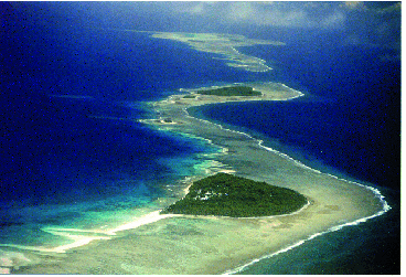
Ulithi is an atoll in the Caroline Islands of the western Pacific Ocean, about 191 km (103 nautical mi) east of Yap. It consists of 40 islets totalling 4.5 km2 (1.7 sq mi), surrounding a lagoon about 36 km (22 mi) long and up to 24 km (15 mi) wide—at 548 km2 (212 sq mi) one of the largest in the world. It is administered by the state of Yap in the Federated States of Micronesia. Ulithi's population was 773 in 2000. There are four inhabited islands on Ulithi Atoll. They are Falalop, Asor, Mogmog, and Fedarai. Falalop is the most accessible with an air strip, a small resort hotel, gas dealership, store and one of three public high schools in Yap state. Mogmog is the seat of the high chief of Ulithi Atoll though each island has its own chief.
Ulithi was a major staging area for the U.S. Navy in the final year of the Second World War. Several sunken warships rest at the bottom of the Ulithi lagoon, including the USS Mississinewa, a fully loaded fleet oiler.[1] The sunken tanker was found to be seeping oil into the lagoon. The United States Navy responded, locating the tanker, tapping her storage tanks, and pumped off her oil. The clean up operation was completed in February 2003.
The atoll offers good fishing and diving, though recent typhoons have eroded some of the reefs.
Census records can be misleading because population can fluctuate during the year because it is common for Ulithians to leave for work or school abroad and to return. This is particularly true during festive times like the Outer Island High School graduation ceremony, when the population can increase considerably. Additionally, during events like weddings and funerals, Yasor's population may double.
Electricity is now available on some islands, and the advent of video players and cell phones have brought a touch of the outside world to this very isolated atoll. Occasional diving and adventure tours visit Ulithi from Yap. Western clothing is prohibited on Mogmog island for everyone including tourists.
History[]
The first European to find Ulithi was the Portuguese navigator Diego da Rocha, in 1526. Its visit was recorded by Spanish navigator Álvaro de Saavedra on board of ship Florida on 1 January 1528. He named them Islas de los Reyes (Islands of the Three Wise Kings in Spanish) because of the sighting happening on the eve of Epiphany. It was later charted by the Spaniards as Islas de los Garbanzos (Chickpeas Islands in Spanish).[2] It remained undisturbed by Europeans until visited and explored in detail by Captain Don Bernardo de Egoy in 1712, and later visited by Spanish Jesuit missionaries led by Juan Antonio Cantova together with a group of 12 Spanish soldiers in 1731.[3]
Germany purchased the islands from Spain in 1899. They were occupied in 1914 by Japan at the outset of the First World War. Japan received them in 1920 as a League of Nations mandate.[1]


Sorlen Island looking into the north anchorage of Ulithi atoll, 1945.
As the Second World War moved west across the Pacific, the US Navy required a more forward base for operations. The Japanese had established a radio and weather station on Ulithi and had used the lagoon as an anchorage occasionally early in the war, but had abandoned it by 1944.
Ulithi was perfectly positioned to act as a staging area for the US Navy's western Pacific operations.[4][5] The atoll is in the westernmost of the Caroline Islands, 360 miles (580 km) southwest of Guam, 850 miles (1,370 km) east of the Philippines and 1,300 miles (2,100 km) south of Tokyo. It is a typical volcanic atoll, with a coral reef, white sand beaches and palm trees. Ulithi's forty small islands barely rise above the sea, with the largest being only half a square mile in area. However the reef runs roughly twenty miles north and south by ten miles across, enclosing a vast anchorage with an average depth of 80 to 100 feet (30 m). The anchorage was well situated, but there were no port facilities to repair ships or re-supply the fleet.[6]


_underway_in_Ulithi_Atoll,_circa_in_March_1945_(80-G-K-3816).jpg)
U.S. naval forces including carriers in the distance at anchor in Ulithi March 1945
On September 23, 1944, a regiment of the US Army's 81st Division landed unopposed, followed a few days later by a battalion of Seabees.[7] The survey ship USS Sumner examined the lagoon and reported it capable of holding 700 vessels—a capacity greater than either Majuro or Pearl Harbor. It became the undisclosed Pacific base for major operations late in the war, including Leyte Gulf and the invasion of Okinawa.
The US Navy transferred the local islanders to the island of Fedarai for the duration of the hostilities. Next came what Admiral Nimitz called his "secret weapon", Service Squadron 10.[8] Commanding officer Commodore Worrall R. Carter devised the miraculous mobile service force that made it possible for the Navy to create repair facilities and re-supply facilities thousands of miles away from an actual Naval port. Service Squadron 10 was called upon to convert the lagoon into a servicable naval station. Pontoon piers of a new design were built at Ulithi, each consisting of the 4-by-12-pontoon sections, filled with sand and gravel, and then sunk. The pontoons were anchored in place by guy ropes to deadmen on shore, and by iron rods driven into the coral. Connecting tie pieces ran across the tops of the pontoons to hold them together into a pier. Despite extremely heavy weather on several occasions these pontoon piers stood up remarkably well. They gave extensive service, with little requirement for repairs. Piers of this type were also installed by the 51st Battalion to be used as aviation-gasoline mooring piers near the main airfield on Falalop.[6]


USS Iowa at a floating drydock at Ulithi
Within a month of the occupation of Ulithi, a complete floating base was in operation. Six thousand ship fitters, artificers, welders, carpenters, and electricians arrived aboard repair ships, destroyer tenders, and floating dry docks. The USS Ajax had an air-conditioned optical shop and a metal fabrication shop with a supply of base metals from which she could make any alloy to form any part needed. The USS Abatan, which looked like a big tanker, distilled fresh water and baked bread and pies. The ice cream barge made 500 gallons a shift.[6] The dry docks towed to Ulithi were large enough to lift dry a 45,000 ton battleship.[8] The small island of Mog Mog became a rest and recreation site for sailors.[9]
Fleet oilers sortied from Ulithi to meet the task forces at sea, refueling the warships a short distance from their combat operational areas. The result was something never seen before: a vast floating service station enabling the entire Pacific fleet to operate indefinitely at unprecedented distances from its mainland bases. Ulithi was as far away from the US Naval base at San Francisco as San Francisco was from London, England. The Japanese had considered that the vastness of the Pacific Ocean would make it very difficult for the US to sustain operations in the western Pacific. With the Ulithi naval base to refit, repair and resupply, many ships were able to deploy and operate in the western Pacific for a year or more without returning to the Naval base at Pearl Harbor.[10]
The Japanese had built an airstrip on Falalop. It was expanded and resurfaced, the runway running the full width of the island. The east end of the strip was extended approximately twenty feet past the natural shoreline.[11] A number of small strips for light aircraft were built on several of the smaller islands. The Seabees completed a fleet recreation center at Mog Mog island that could accommodate 8,000 men and 1,000 officers daily. A 1,200-seat theatre, including a 25-by-40-foot stage with a Quonset hut roof was completed in 20 days. At the same time, a 500-seat chapel was built. A number of the larger islands were used both as bases to support naval vessels and facilities within the lagoon.[12]

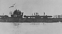
A Japanese submarine carrying kaiten to their deployment.


_20_November_1944B.jpg)
USS Mississinewa burns while sinking following an attack by Japanese kaiten
The Japanese still held Yap. Early after the US occupation they mounted a number of attacks but caused no damage to the Seabees working on the islands.
On 20 November 1944 the Ulithi harbor was attacked by Japanese kaiten manned torpedoes launched from two nearby submarines. The destroyer USS Case rammed one in the early morning hours. At 5:47 the fleet oiler USS Mississinewa, at anchor in the harbor, was struck and sunk. Destroyers began dropping depth charges throughout the anchorage. After the war Japanese naval officers said that two tender submarines each carrying four manned torpedoes had been sent to attack the fleet at Ulithi. Three of the suicide torpedoes were unable to launch due to mechanical problems and another ran aground on the reef. Two did make it into the lagoon, one of which sank the USS Mississinewa. A second kaiten attack in January 1945 was foiled when the I-48 was sunk by the destroyer escort USS Conklin. None of the 122 men aboard the Japanese submarine survived.[13]


_under_repair.jpg)
The USS Randolph undergoing repairs following a kamikaze attack at Ulithi
On March 11, 1945, in a mission known as Operation Tan No. 2, several long range aircraft flying from southern Japan attempted a nighttime kamikaze attack on the naval base.[14] One struck the Essex-class aircraft carrier USS Randolph, which had left a cargo light on despite the black out. The plane struck over the stern starboard quarter, damaging the flight deck and killing a number of crewmen.[15] Another crashed on Sorlen Island, having perhaps mistaken a signal tower there for the superstructure of an aircraft carrier.[16]
By March 13 there were 647 ships at anchor at Ulithi, and with the arrival of amphibious forces staging for the invasion of Okinawa the number of ships at anchor peaked at 722.
After Leyte Gulf was secured, the Pacific Fleet moved its forward staging area to Leyte, and Ulithi was all but abandoned. In the end, few US civilians ever heard of Ulithi. By the time Naval security cleared release of the name, there were no longer reasons to print stories about it. The war had moved on, but for seven months in late 1944 and early 1945, the large lagoon of the Ulithi atoll was the largest and most active anchorage in the world.[6]
Language[]
In an annual report released in early 2010, the Habele charity announced plans to develop and distribute native-language materials for educators and students in the outer islands of Yap State, Micronesia. The first project was a Ulithian-to-English dictionary.[17] This was the first rigorous documentation of the Ulithian language, and copies were provided to educators and students throughout Ulithi and Fais[18] The authors' stated aim was to create a consistent and intuitive Latin alphabet useful for both native Ulithian and native English speakers.
References[]
- Citations
- ↑ 1.0 1.1 Bob Fulleman (November 2009). "AO-59 USS Mississinewa". http://navy.memorieshop.com/Mississinewa/WWII.html.
- ↑ Langdon, Robert The Lost Caravel Sidney, 1975, p.268
- ↑ James Burney (1817). A Chronologic History of the Discoveries of the South Sea or Pacific Ocean. London: printed by Luke Hansard. ISBN 978-1-108-02411-2.
- ↑ Brent Jones (December 2007). "Reporting For Duty". Mighty Ninety, The Homepage of USS Astoria CL-90. http://mighty90.com/Reporting_for_Duty.html.
- ↑ "Building the Navy's Bases in World War II: History of the Bureau of Yards and Docks and the Civil Engineering Corps, 1940-1946". p. 332. http://www.ibiblio.org/hyperwar/USN/Building_Bases/bases-27.html.
- ↑ 6.0 6.1 6.2 6.3 George Spangler (March, 1998). "Ulithi". USS Laffey. http://www.laffey.org/Ulithi/Page%201/Ulithi.htm.
- ↑ "Battle for Anguar and Ulithi (Operation Stalemate II) September 1944". Military History Encyclopedia on the Web. http://www.historyofwar.org/articles/battles_angaur.html.
- ↑ 8.0 8.1 "ServRon 10: Floating Arsenal". November 1945. pp. 59.
- ↑ Where is Mog Mog?
- ↑ "World Battlefronts: Mighty Atoll". Time. August 6, 1945. http://www.time.com/time/magazine/article/0,9171,803663,00.html#ixzz1HkugXQuv.
- ↑ Tim Lanzendorfer (November 2003). "Ulithi in the western Carolines". The Pacific War: The US Navy. http://www.microworks.net/pacific/bases/btnb_online/ulithi.htm.
- ↑ Morison pp. 47–50.
- ↑ "Japanese submarine losses". http://www.asahi-net.or.jp/~un3k-mn/kai-sen.htm. Retrieved 16 September 2010.
- ↑ Arnold, Bruce Makoto. An Atoll on the Edge of Hell: The U.S. Military's Use of Ulithi During World War II. Unpublished M.A. Thesis, History. Sam Houston State University, 2007.
- ↑ Potter p. 241
- ↑ Bob Hackett (2007). "Operation Tan No. 2: The Japanese Attack on Task Force 58's Anchorage at Ulithi". http://www.combinedfleet.com/Tan%20No.%202.htm.
- ↑ "FORMER MICRONESIA PEACE CORPS GROUP FUNDS SCHOLARSHIPS" Pacific Island Report, East-West Center, January 28, 2010.[1]
- ↑ "Charity Publishes Dictionary For Remote Micronesian Islanders " COM-FSM, May 10, 2010.[2]
- Bibliography
- Arnold, Bruce Makoto (2007). An Atoll on the Edge of Hell: The U.S. Military's use of Ulithi During World War II. Sam Houston State University, M.A. Thesis.
- Morison, Samuel Eliot (1958). History of United States Naval Operations in World War II: Leyte. Little, Brown and Company.
- Potter, E. B. (2005). Admiral Arliegh Burke. U.S. Naval Institute Press. ISBN 978-1-59114-692-6.
External links[]
| Wikimedia Commons has media related to Ulithi. |
- Ulithi South Pacific Naval Base George Spangler, March 1998
- Community-2.webtv.net/ebb26/ULITHI (note factual inconsistencies with Morison)
- Ulithi World War II Project
- Account of the March 11, 1945 kamikaze attack on Randolph.
- Habele, an educational charity serving Ulithi
Coordinates: 9°58′12″N 139°40′12″E / 9.97°N 139.67°E
The original article can be found at Ulithi and the edit history here.